

tuanis
-
Posts
741 -
Joined
-
Last visited
Content Type
Profiles
Blogs
Forums
American Weather
Media Demo
Store
Gallery
Posts posted by tuanis
-
-
After melting and compaction almost all day we’re finally accumulating again
-
 1
1
-
-
Light rain under lighter returns. Big globs of garbage falling off the trees and splashing in puddles. Good times.
-
 1
1
-
-
This stuff is as wet and heavy as anything ive ever cleared. Nasty slush and the snowblower is struggling. We can’t seem to get a nice cold snowstorm anymore.
-
All sleet now. Got around 5” this morning but melting pretty quick.
-
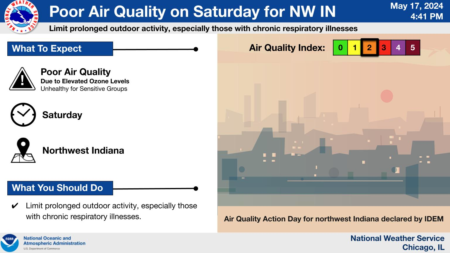
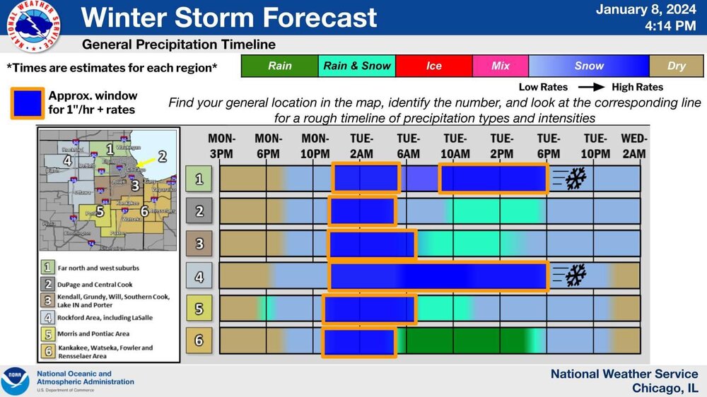
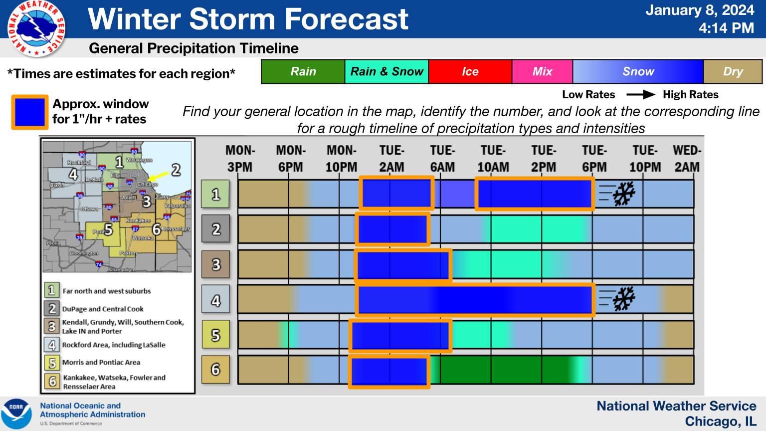
For the Chicago metro it all comes to what falls from the sky this afternoon, where that rain/snow line sets up, and when it crashes southeast. This period has been the concern with the storm for awhile.
-
2
-
-
Coming down and accumulating well for the moment, but looks to cut off within an hour. While the main show is wrapping up, there will be another slug of precip for about 5 hours this afternoon, but temps look iffy. As the low pulls into Michigan we'll get some wrap around snows as the arctic air spills in adding another inch or two.
-
Giant parachutes swirling on whipping winds. Power keeps cutting out but is still on. Cool to see these rates, especially during daylight now. Still not convinced we don’t see some rain today. The snow is so wet the east-facing windows are all covered in icy water from the wind blasting them
-
Just woke up. It’s snowing so hard that all of the motion sensor lights in the neighborhood are triggered at the same time. Everyone’s properties are lit up like a prison yard

Looks like it’s about to shut off for awhile per radar.
-
1
-
3
-
-
1 minute ago, Lightning said:
Lately flights are delayed even with clear calm weather.
Flying is truly a lovely experience.
As for this storm... lots of dynamics at play and really difficult to make out what will happen, at least locally. The comparison in LOT's AFD to the 1987 heart attack snowstorm was interesting. Like that one, this storm will bomb out quickly. I imagine as that happens rain will quickly flip to snow over a large area. Feels like there are many more surprises to come... hopefully good ones. I really don't know what to expect.-
1
-
-
2 minutes ago, Possum said:
This feels like a dumb question but can anyone give me odds on a 9:30am flight on Saturday out of Midway happening? I’ve got some nephews in Dallas who are excited to see me, but the thought of trying to dig out that morning and make it from Humboldt Park to Midway just to sit around through delays and possibly cancellation instead of being cozy at home is stressing me out.
.Reschedule that flight. Winds alone are going to screw with everything.
-
1
-
-
17 minutes ago, RCNYILWX said:
If anyone has specific LOT centric questions on forecast stuff from today, ask away and I'll try to reply a bit later.
Apologies for the lack of a more in depth meteorological dissertation in the AFD lol - just less and less time available for us on days like this.
Sent from my SM-G998U using Tapatalk
Thoughts on "less slop, more snow"? Hard to really tell, but looks like precip/dynamics may be shutting down by the time the arctic air gets pulled into the system and profiles cool. Could this be another repeat of Mon-Tue when even Rockford was plagued by marginal temps, inefficient accumulation, mixed precip and lousy snowfall for 3/4 of the storm?
-
My only wish for this one: less slop; more snow. So much potential for some of us with that airmass getting pulled into it.
-
2
-
-
Note to future self: WAA snows in a marginal antecedent airmass close to a warm lake will always suck regardless of what the models say. Finally starting to crank out there and sticking too. Looking for 2" or bust.
-
2
-
-
13 minutes ago, TheClimateChanger said:
Weird how Midway has had more than Rockford. Doesn't seem possible.
Rockford's closing that gap and will take the lead in no time: https://www.mystateline.com/skytrack-rockford/
It's kind of snowing here now... big gloopy flakes coming straight down that look like raindrops in the puddles. Nothing like that webcam.-
1
-
-
Updated timeline per LOT. Forecast says I flip to all snow by 11 while this graphic says a period of heavy snow starting shortly after 1. White rain at the moment and not feeling too optimistic about stacking much more than an inch this afternoon. In-laws in Lake Zurich said it's been mostly rain there so far as well.
-
11 minutes ago, StormChaser4Life said:
Some cam guidance not as gunhoe
The term is actually gung ho and your post made me look up where it came from. Kind of hilarious, actually: https://en.m.wikipedia.org/wiki/Gung_ho
Still rain here, not expecting much today even when the defo pulls through here. Don’t want to lose Friday!
-
1
-
1
-
-
Woke up to a little white in the grass and a light rain falling.
-
14 minutes ago, homedis said:
1.2 miles here. Im gonna get all rain, arent I?I really think the LOT has the right idea here. Except there will prob be some liquid up here too.
-
1
-
-
19 minutes ago, Baum said:
oh ye of little faith.......
You’re 15 or so miles from the lake vs. my 5. You’ll do much better than I.
-
Still think it’ll be a rainy mixy slop that doesn’t amount to much with tomorrow’s batch even if model trends have been positive. 20+ miles west it’ll be another story.
-
Looks pretty sloppy with the marginal temps. Like where I sit but don’t think it’ll amount to too much unless that defo band can really rip. Hoping for 5.1” but that can bust in a big way. If it delivers imagine I’ll be knocking wet slop off the young trees in the yard with a broom.
-
1
-
-
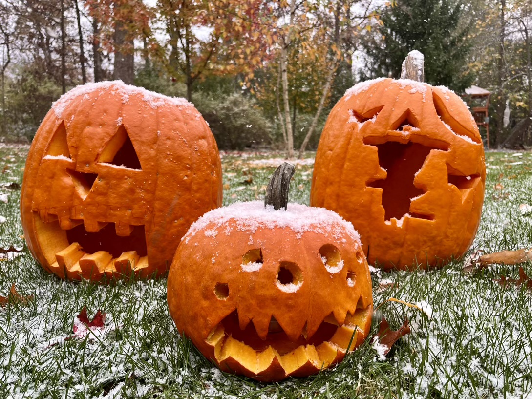
Happy Halloween, good to be back in the game. Hopefully these aren’t the best rates of the winter

-
12
-
-
2 minutes ago, A-L-E-K said:
Feeling decent about getting clipped here
Can’t tell if this stuff will crap out this evening or not. I’m not feeling as optimistic as you even though it’s not far off at all. Just want a light show.
-
Quality houseshakers

Jan 11-13th Blizzard
in Lakes/Ohio Valley
Posted
The morning after. Amazing what a few inches of wraparound higher ratio fluff can do.