

Bango
-
Posts
300 -
Joined
-
Last visited
Content Type
Profiles
Blogs
Forums
American Weather
Media Demo
Store
Gallery
Posts posted by Bango
-
-
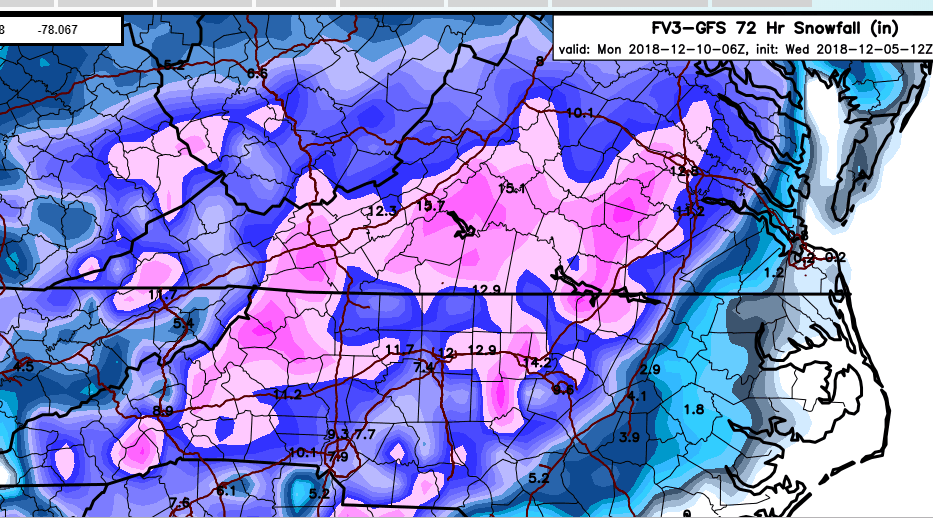
The duration of the event is pretty awesome, with some regions east being in the midst of a 50 plus hour event depending on the east coast track
-
Shew if that low would hug the nc coast a bit more, would be quite epic for east tn
-
A rather highly anticipated 12z euro run awaits...kinda feeling cautiously optimistic here
-
Fv3 is still frozen for me @96..stolen from se board, not too focus on micro level stuff but congrats kingsport/gate city
-
 1
1
-
-
5 minutes ago, Coach B said:
Look at the warm nose into middle TN/S KY! Dang, I hate to waste a chance at a system taking what would ordinarily be a perfect track. I really cant figure a warm nose like that with the LP over Jacksonville?? Why the heck are the 850s not dropping when it goes by to the south?
There seems to be some wiggle room in the path, cmc and to some degree, the fv3, both slide the low into lower alabama. Considering we need all the help we can get, I hope we see more of the tracks like the 12z gfs, that slide it more easterly and off panama city by 50-100 miles. Ive noticed that the historic clown maps tended to have this progression
-
Thought the totals would be more clownish after this look...pretty much the perfect path, which is what it's apparently gonna have to do in conjunction with all the other variables

-
1
-
-
Incoming 12z gfs prolly gonna end as a smash fest for upper east tn valley
-
On the Fv3, Some areas of east tn show snow/frozen precip for 55 hours lol. It's a little concerning that the low placement rides up almost into mid alabama, but checking prior runs, they also show it riding considerably north before moving east (not as much). I would not have thought such a inland path could paint such results for upper east tn, but inversely, some of the money paths on gfs do not, so there's that
-
1
-
-
I don't pretend to know if this is significant or not, but carver noted the loss of the high as the icon progressed, and some in the se forum were noting this in the latest ukmet late in its run...
-
Oz gfs, similiar issues as prior runs, sexy track, borderline temps, meh result
-
1 minute ago, Wurbus said:
00z Nam looks super cold. The high is at 1041 at the end of the run. The system looks a little more suppressed because of this.
Rehashing my mind, nam tends to have a cold bias and higher precip bias, correct?
And for those of us in the northeast tn or southeast ky, we want a little weaker high (but not too weak?)
-
I thought she might be dipping to Cuba there at the start
-
 2
2
-
-
2 minutes ago, Holston_River_Rambler said:
18z FV3 just came out to play! South and more Euro-ish.
A weird run to achieve a similiar result
-
My mind is now blown as well ha. There is an 18z euro, and fv3 has decided to go kapoot
-
1
-
-
5 minutes ago, Wurbus said:
Wow. That map is AMAZING. I would like to cash in now please. I am still expecting Knoxville to get a warm nose (just to temper my excitement and climatology), but if we could get half that I would be pleased. Looks like most of the rest of the forum can cash in as well!
On another note, I'm not getting any work done this week.
")
Retire indeed, it literally would be the type of storm youd prolly never see again?
-
5 minutes ago, John1122 said:
No clue, I don't recall ever seeing anything like that actually happen before, but it's obviously technically possible. I'm personally going to discount it. I assume the model sees some brief weakness in the high over the top and thinks the system will slam the brakes on and shoot north but then be forced to resume eastward.
Without that hiccup, and smoothing out the trajectory starting south of panama, I am guessing it would look like the ever so southerly version of its 6z path. Dunno how that would affect the northern areas of tenn?
-
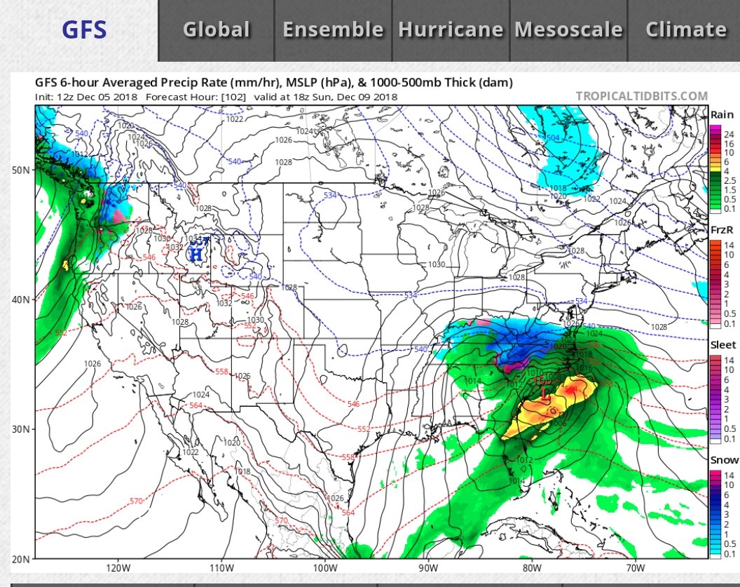
What's up with the almost vertical jog north coming out of the gulf, centering in lower bama, on the fv3?
-
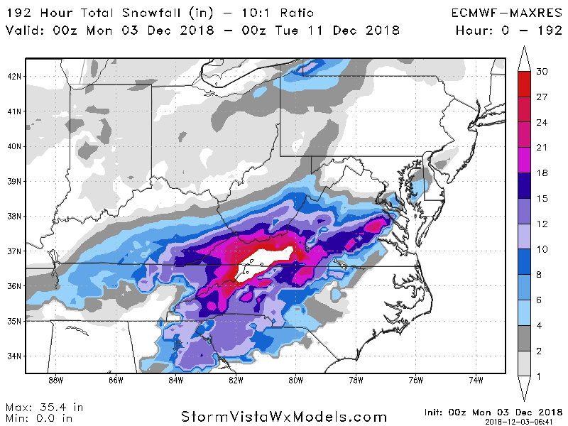
Lawdy at the crush in the nc mountains and piedmont from the 12z gfs, for under 5 days, might be the clown of all clowns for that region.
Still lightly snowing back in ky/tn some 48 or so hours later lol, although big totals are hit/miss above i40
-
5 minutes ago, BlunderStorm said:
Tonight the ICON took another step in the right direction. Hopefully this is the story for the whole model suite.
Dreamy path for the low on the ICON for much of i40 north, which for that particular model, is about all I take away. As john stated, the route, for 5 days out, is really honed in even if the wobbles and details remain subject to change
-
2
-
-
Are these fv3 snowfall outputs remotely correct ha? This is dgex type algorithms
-
1
-
-
I m feeling increasingly optimistic with how consistent the euro/fv3 are. I don't see the same run to run consistency in the gfs or cmc, or any reason to weight them anywhere close to the euro or fv3
-
1
-
-
19 minutes ago, John1122 said:
The FV3 track and positioning of upper features is textbook for us and you can look back at some big past storms and see virtually that exact set up. HP in the area of SE Minnesota to Chicago and another near Pennsylvania will often show up in our major snow events.
The last few years we've seen this level of model consistency for days on end, only to have it go awry in the last 2 days. Oddly we see these set ups verify from way out for storms for almost every other area of the country. Even last year's very odd deep south snows held steady and worked out.
For me, I may get truly excited if this looks good on Friday.
I feel you, in addition it seems like more often its the qpf totals that start getting dramatically slashed in halves 24-48 hours prior to well modeled events....that is usually the Charlie Brown I look for as we gett closer
-
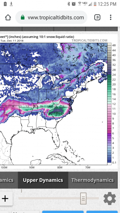
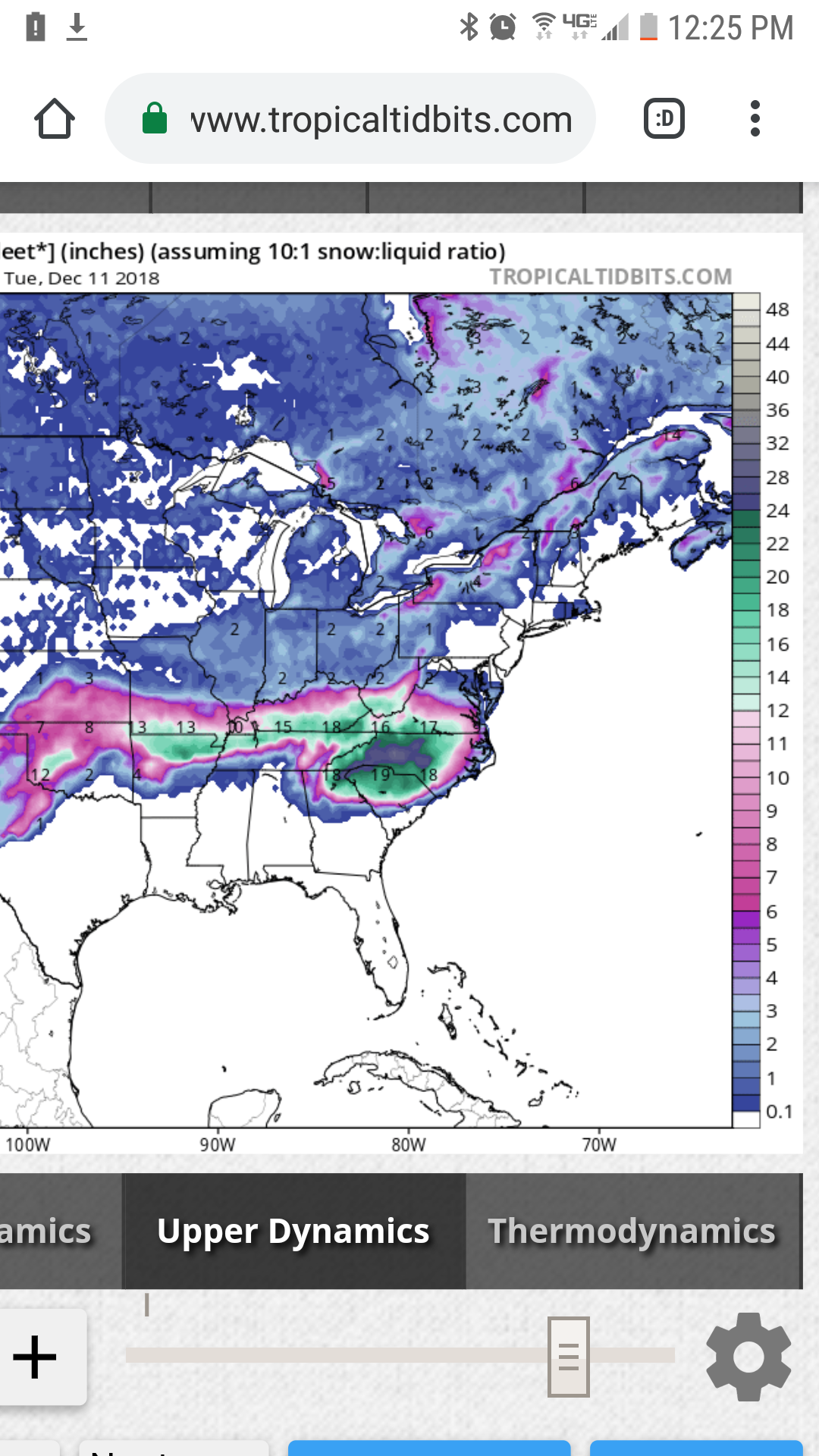
5 minutes ago, griteater said:
Euro Clown Map
Is that cm or inches?
-
December snow is the best, and while ill always take a Christmas snow, I actually enjoy a snow leading up to Christmas as much or more (although Christmas eve might be the pinnacle for a snow event) than Xmas day snow etc. Gets me in the festive mode if we can get a snow between Dec 5 onward
-
1
-
December 8-10 Storm Discussion
in Tennessee Valley
Posted
Which would benefit more of tn?