

Dan
-
Posts
1,240 -
Joined
-
Last visited
Content Type
Profiles
Blogs
Forums
American Weather
Media Demo
Store
Gallery
Posts posted by Dan
-
-
Great breeze here and lots of sun. Beautiful day.
. -
I went back and reviewed my webcam that has an unlimited view to the south through westsouthwest. There was a flash at 1109:30pm. It looked like distance lightning from my vantage point in Central NH
There was a boom with it as well. Took a while to reach. I saw no other flashes but that one. Maybe there was a rogue lightning. Only storms at the time were in far western NH and southern Vermont, I believe
. -
Anyone experience a bright flash about 11:10 PM? Any reports of meteorites? Lit everything up as I was driving home. No storms in the area. Just lots of low clouds and some drizzle. And no I wasn’t drinking.
I saw it too. Looked at the radar and it was completely empty. I’m over in southeast NH. Was off to the west
. -
Yup. I have had it too. Had it on the top of my head and my forehead, hurt like hell.
-
 1
1
-
-
7.25" here. Think I just barely stayed out of the rain.
-
Well this should be fun...Heading to Plattsburg on Saturday to visit my grandmother. She hasn't been feeling well and is 102, so can't really switch it. Certainly should have some great pictures Sunday morning.

-
 2
2
-
-
Hey Kevin,
If its not too late. I am in for this year again. Dan in Brentwood. Sorry have been away from the board for awhile.
-
4.75" with some pingers starting to mix in from time to time. 19.5*
-
4.25”. Still all snow. No sleet yet
. -
4.5" here.
-
Light snow and flurries on my way into Andover from Southeast NH this morning. Not accumulating anywhere, just mood flakes.
-
Temps at 10!
Ansonia ct
Beautiful pic
. -
7 minutes ago, HoarfrostHubb said:
Precip amounts way overmodelled here. 6” snow before compaction, not a huge amount of sleet...less than 1”. If it wasn’t going to be all snow I’m glad. Suckerhole ftw.
Same here. 5 1/2" about an hour ago.
-
5 1/2" snow/sleet. 1" sleet in the last 2 hours...been light to moderate most of the morning.
-
4.5” here. Snow hole for the loss
. -
Terrible rates/vis here at GYX for a storm hoping to get into the double digits.
Same here. Awful. Haven’t been out yet but doesn’t look like more than maybe 3”
Pinging here
-
23 degrees. 1/2” down -SN
. -
It's a screenshot of a video so the quality is trashy, but the hype from Weather Channel is insane. Where are they finding 3+ feet of snow?? Please don't tell me they're using Kuchera ratio...
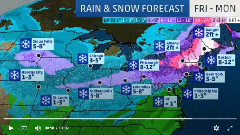
I think they are. The twc app for my area has 1 foot or more Saturday night and 1 foot or more for Sunday. Then another 1-3 on Sunday night
. -
Are all the players being sampled yet?
-
Pouring here the last 15 minutes, but the temp has been creeping up since about 4:30. At 4:30 I was at 29, now I am just barely above 32. I am in southeast NH, just outside of Epping and Exeter.
-
8 minutes ago, 40/70 Benchmark said:
Wilmington and Methuen are very similar....Methuen is just a bit more resistant to coastal fronts and do better in SWFE.
Snowfall difference is negligible, but retention and increased potential for icing are relatively substantial due to the coastal front issue.
Yeah I suspect that if you compare my numbers for the last few years, they are probably very close snowfall wise.
-
1.5” here.
. -
Some light snow coming through here right now.
-
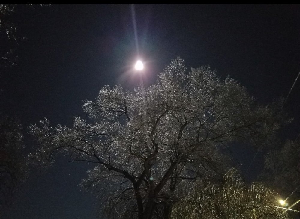
Very Christmas Cardish this morning. Came to work in Andover and there was nothing on the trees.

July 2020 Discussion
in New England
Posted
Looks refreshing here: