

Isopycnic
-
Posts
14,544 -
Joined
-
Last visited
Content Type
Profiles
Blogs
Forums
American Weather
Media Demo
Store
Gallery
Posts posted by Isopycnic
-
-
22 minutes ago, kvegas-wx said:
I look at it the other way around, a big VD snow means I aint gotta take her out and she can cook me a big ole sketti dinner. I will build the fire though.


-
1 hour ago, WinstonSalemArlington said:
I’m looking forward to my 0.01” of sleet
-
 1
1
-
-
24 minutes ago, burrel2 said:
eyore is a fictional character in the Winnie-the-Pooh books by A. A. Milne. He is generally characterized as a pessimistic, gloomy, depressed, anhedonic, old grey stuffed donkey
sums up eyewalls general demeanor every winter, lol
I miss widremann
-
 5
5
-
-
1.9” snow. 0.19” of liquid equivalent. 2.1” now in the yard .
-
2
-
-
20 minutes ago, Brick Tamland said:
Finally started snowing
Thank f’ing gawd!
-
1
-
8
-
-
5 minutes ago, Brick Tamland said:
Wow, we keep having these threats showing up about 7 days after each other. Been a long time since that has happened.
Yeah, last winter.
-
4
-
10
-
-
5 minutes ago, Grayman said:
Does anyone have time to post a link to the best site for nowcasting? Someone posted SPC mesoscale but honestly I’m still learning and don’t know exactly what I’m looking for. Thanks
-
 1
1
-
-
31.7” rain gauge started tipping.
-
Almost 2” of sleet and snow before changeover to freezing rain. Temps rising fast.
-
Changed to freezing rain .
-
Heavy sleet baby!
-
Moderate sleet b!tches!
-
Snow but transitioning to sleet. You can see the transition on the correlation coefficient on the radar.
-
2
-
-
Moderate snow with 1/2” accumulation west Durham. Roads are white
-
Reminder.use the mPing app to report your conditions.
-
3
-
-
Light snow western Orange County south of hillsborough on pickards mountain.
-
2
-
-
21 minutes ago, Brick Tamland said:
BrickistheGOAT
BRICKtheWEENIE
-
4
-
5
-
 1
1
-
-
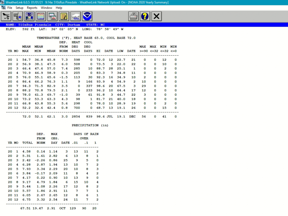
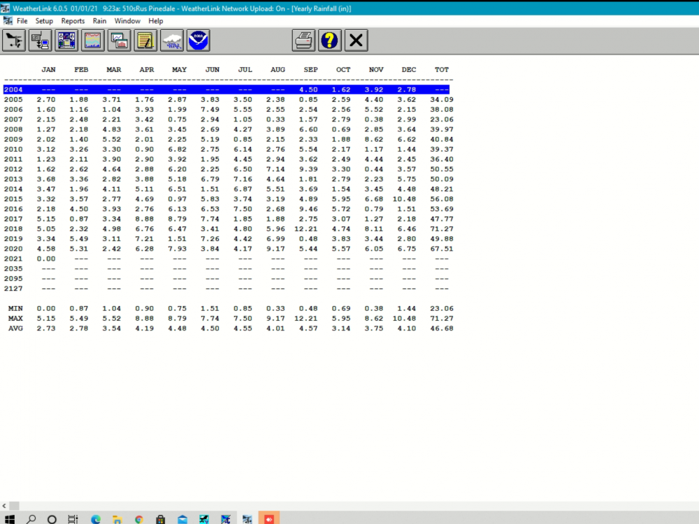
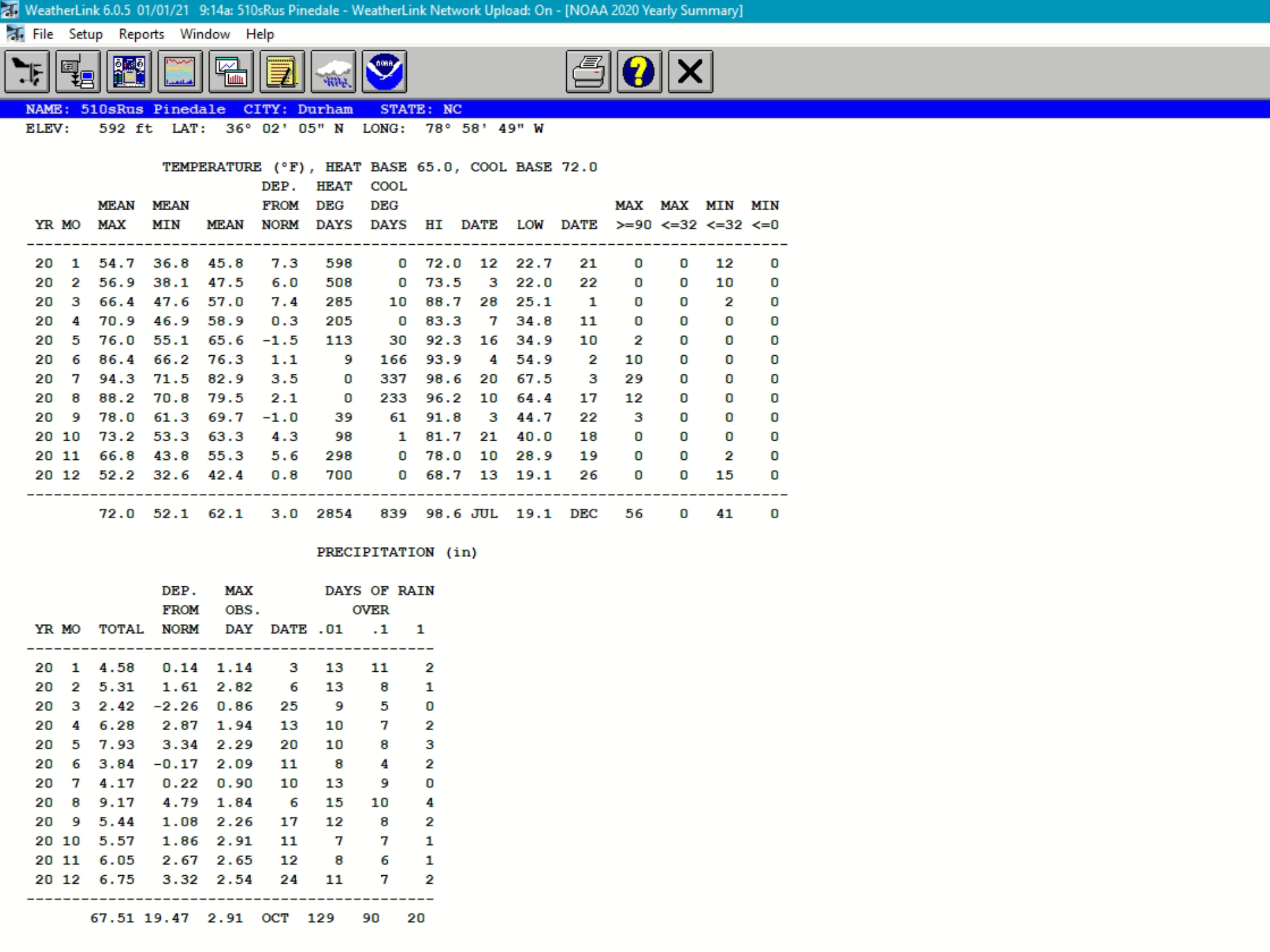
Happy New Year!
2021 weather stats from my front lawn.
Calendar year 2021 statistics:
Mean Temp: 61.5f (+2.3f)
-----------------------------------------Max Temp: 96.7f
Mean Max: 72.0f
-----------------------------------------Min Temp: 21.3f ( Thats not very cold… :0 )
Mean Min: 51f
------------------------------------------Rainfall: 42.70” (-5.34”)
Snowfall: 0.19”(0.19” 2019/20 season)
-
3
-
-
Warm, wet. .. COVID.
-
1
-
-
2.09” yesterday. Most of it falling in an hour. Some areas a mile or two north of me had 6+ inches.
-
0.74” from Bertha
-
On 5/21/2020 at 6:04 AM, Isopycnic said:
5.70” storms total. Still pouring.
6.43”
-
23 hours ago, Isopycnic said:
1.90”
2.82” storms total
5.70” storms total. Still pouring.
-
On 5/19/2020 at 6:10 AM, Isopycnic said:
0.26” from arthur
0.88” storm total so far.
1.90”
2.82” storms total

Hurricane Ian
in Tropical Headquarters
Posted
Thanks Ray! Awesome.