

Kaner88
-
Posts
307 -
Joined
-
Last visited
Content Type
Profiles
Blogs
Forums
American Weather
Media Demo
Store
Gallery
Posts posted by Kaner88
-
-
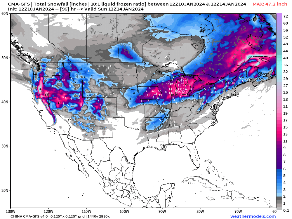
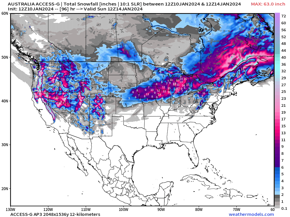
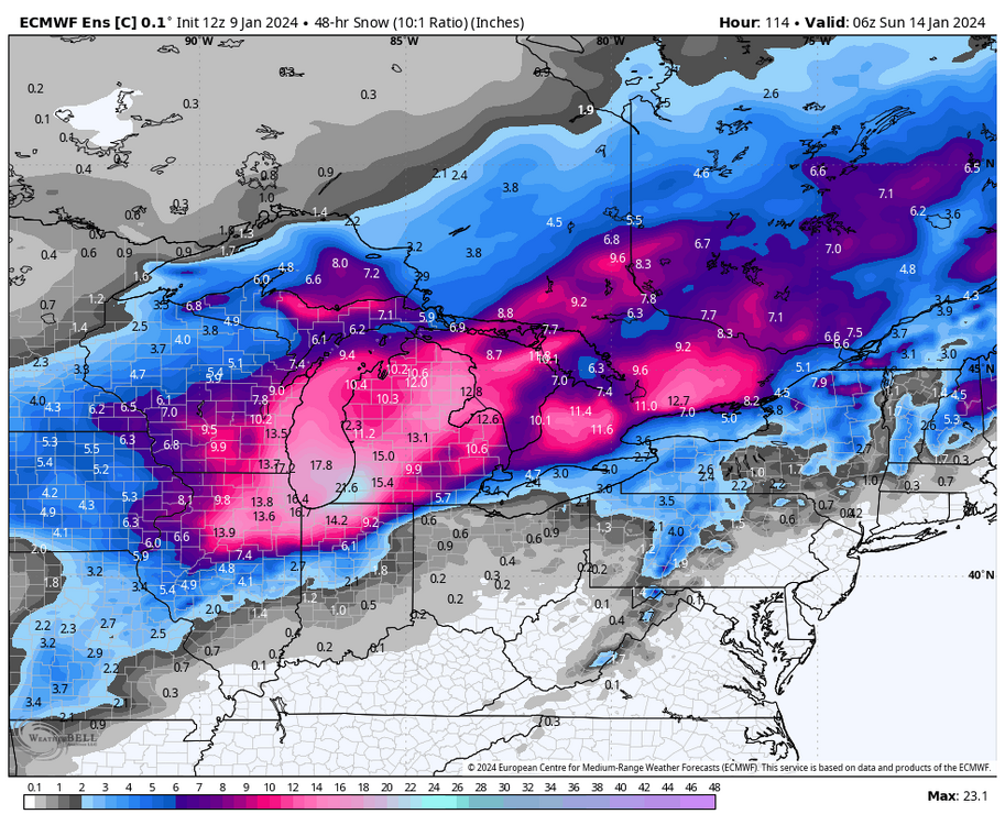
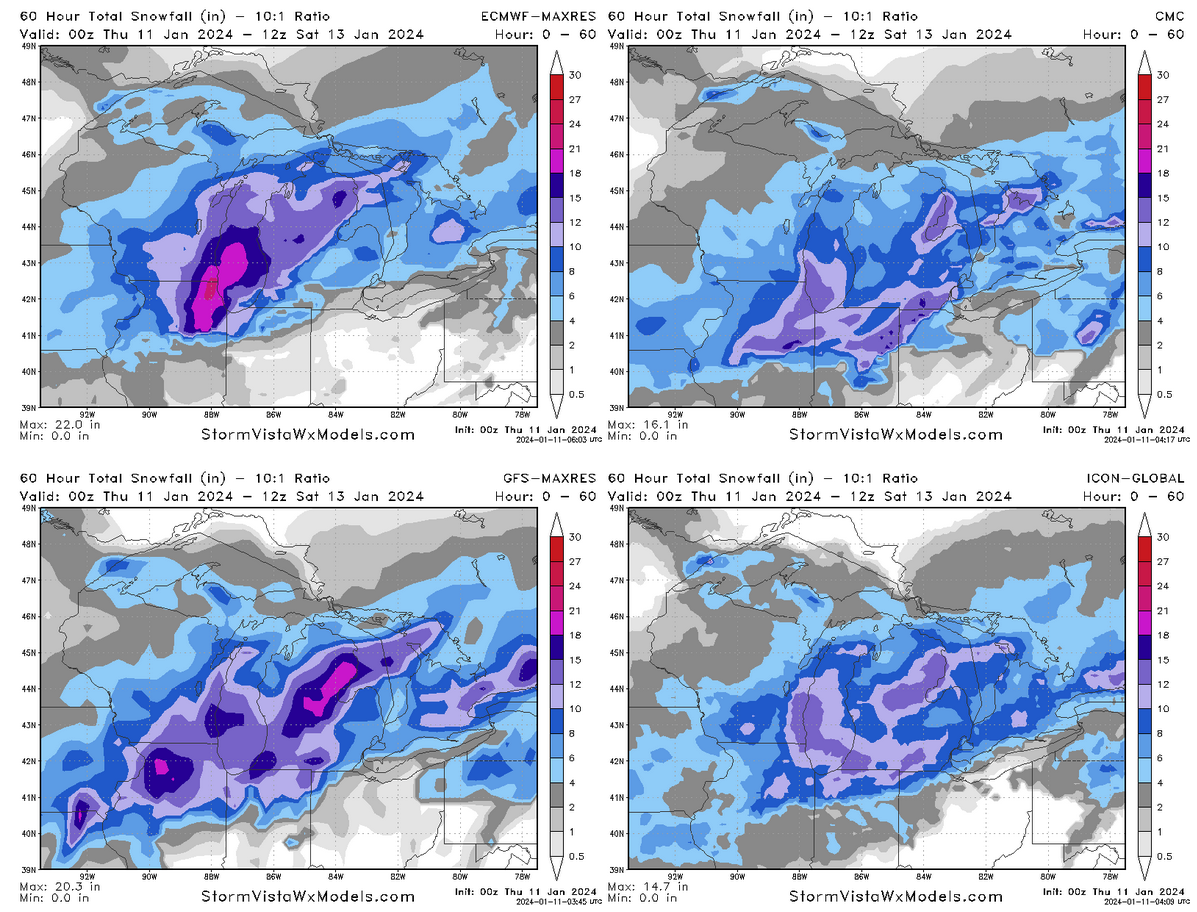
silly level of disagreement on snow across the GL region with less than 72 hours before things are rockin'

-
Euro going gangbusters on Chicago
-
2 minutes ago, A-L-E-K said:
chuck 'em deep
how can you ignore an ironclad Korean/Aussie/Chinese consensus
-
 6
6
-
-
don't worry, i've got all the esoteric models you could want
the australians are all in
-
 3
3
-
-
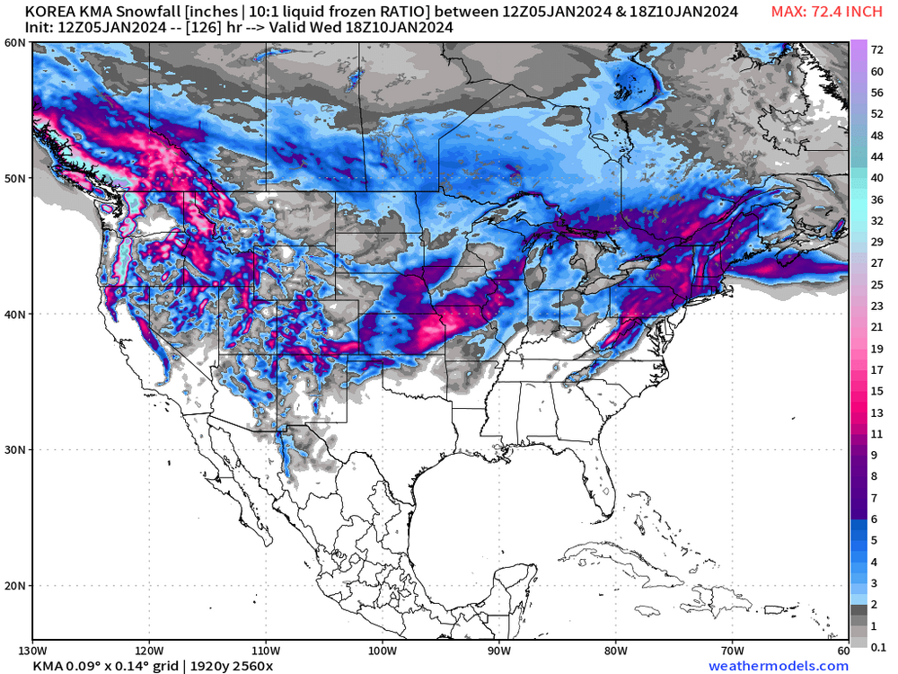
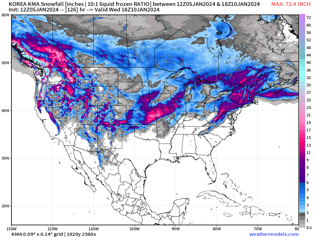
The Korean is not impressed
![KOREA KMA [10-KM] Snowfall Snowfall 84.png](https://www.americanwx.com/bb/uploads/monthly_2024_01/329377476_KOREAKMA10-KMSnowfallSnowfall84.thumb.png.f6c16551e2c5adcfd05d7602d6a9f339.png)
-
Not to be outdone, Euro ENS control attempts to fully bury the region
-
3
-
-
Korean model no longer on friendly terms with Alek's call
![KOREA KMA [10-KM] Snowfall Snowfall 120.png](https://www.americanwx.com/bb/uploads/monthly_2024_01/326516273_KOREAKMA10-KMSnowfallSnowfall120.thumb.png.03d9b8d96f09d2cf6b863d44695fdee8.png)
-
3
-
-
13 minutes ago, Chicago916 said:
Imagine what the DGEX would've been doing with this storm... Glad that was retired years and years ago tho. Not this storm but radar looking good for a DAB tonight. Some decent banding.
I dunno, one of the best parts of winter storm tracking is the eye-watering snow totals put out by a few choice models. DGEX was always reliable for a good 36"+ somewhere in its forecast timeframe. RIP
-
1
-
-
NAM going nuclear on the Huskers, guess they have to win something once in a while
-
4
-
-
King KMA takes it into Milwaukee
-
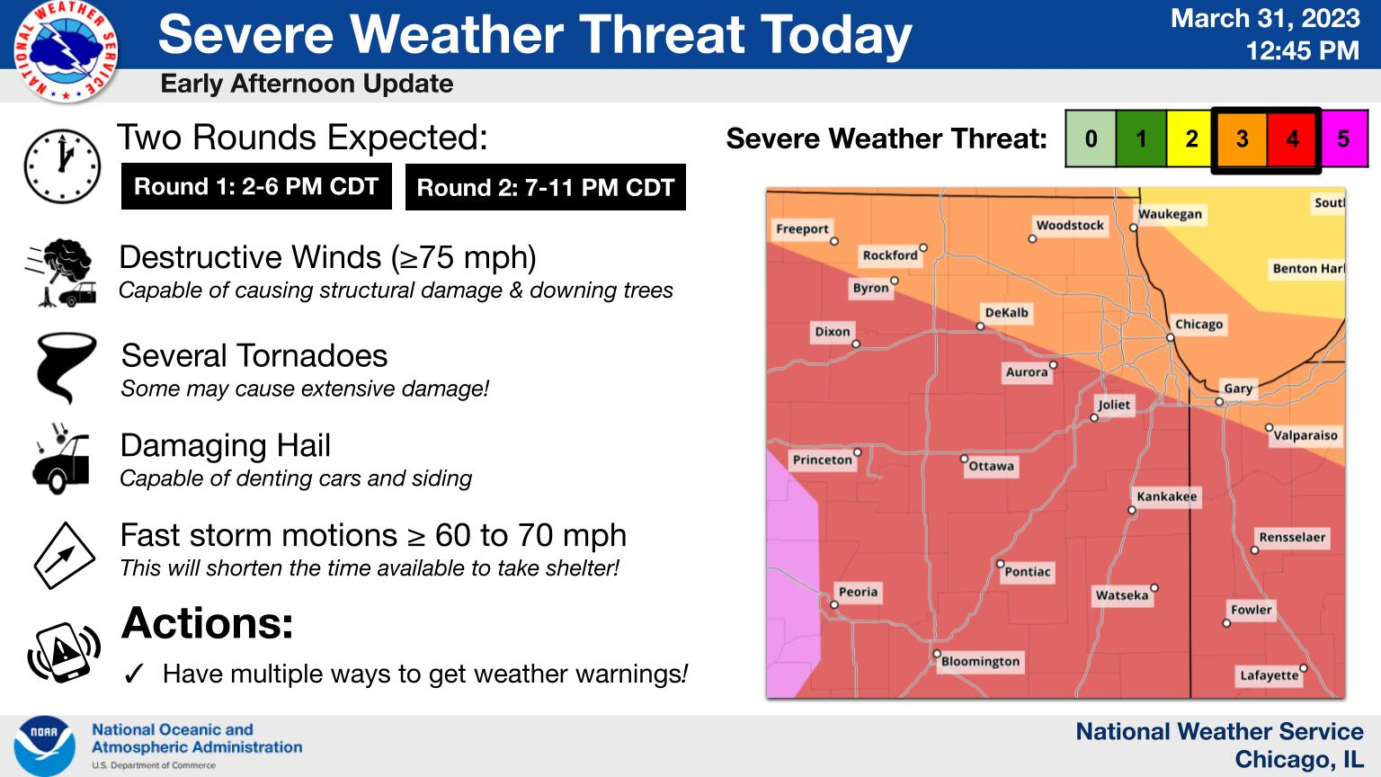
Really enjoyed LOT's morning AFD, gets into some of the juicy modeling stuff:
QuoteMain focus then turns to the potential for severe weather mainly late Tuesday afternoon and evening. As we`ve been noting, this setup appears to be much more "conditional" than last Friday`s for a number of reasons. First is that large scale forcing will be more subtle/weaker as the parent 500 mb low is currently forecast to be well west across western/central Nebraska and South Dakota by early Tuesday evening. Second is that capping will be playing more of a central role as an expansive EML plume characterized by extremely steep mid-level lapse rates and attendant warm nose around 800 mb will likely result in considerably MLCIN through much of the afternoon hours. Whether or not the aforementioned subtle large scale forcing is able to overcome this is one of the main questions yet to be answered and will mean the difference between few to no storms in the local area versus a potential significant severe episode in the region.
From a conceptual standpoint, the surface warm front will make slow, but gradual northward progress through the region on Tuesday as more notable pressure falls develop across Wisconsin and Iowa. Seems like the front`s forward progress will probably get held up a bit by the cool lake with it having a harder time making progress north of the Wisconsin state line during the evening. Wide open Gulf trajectories will allow an expansive region of 60s dewpoints to surge northward although forecast soundings continue to indicate the moist layer will be somewhat shallow. Still, seeing signs of higher dewpoints pooling near the warm front, possibly in response to mixing into higher mixing-ratio air just off the surface (with this in mind drizzle and pockets of fog appear possible Tuesday morning and even into the afternoon north of the front). Even the WRF-ARW which utilizes a more aggressive PBL scheme and tends to readily "mix-out" shallow moist layers holds onto low 60s dewpoints up to the I-88 corridor.
The big question here is whether the base of the relatively warm EML plume can be lifted and cooled sufficiently by only very modest large scale forcing for ascent with neutral or even positive mid-level height tendencies noted over us in a narrow window during the late-afternoon and early-evening. The ECMWF and GFS both have been consistently saying "yes" to this question as the nose of a 60-70 kt 500 mb jet max pushes across central Illinois during the afternoon hours, but it`s easy to find other guidance which says "no", leaving too much convective inhibition in place for thunderstorm initiation. That said, am somewhat concerned by potential trends noted in hires guidance which seem to be headed more towards the ECMWF/GFS camp in eroding the capping layer just enough to result in explosive thunderstorm development somewhere across eastern Iowa/northeast Missouri/west-central Illinois, and seems like more than half of the EPS members do so as well based on a cursory glance.
IF convection develops, it would have access to an highly volatile cocktail of high instability and truly eye-popping kinematic parameters with large, sweeping/looping hodographs driving very high effective SRH and, importantly, significant low-level storm-relative inflows. While a cap bust scenario is still on the table (one where inhibition remains too high and storms struggle to develop or don`t develop at all), it`s hard (and probably foolish) to ignore the consistency of the ECMWF, GFS, and now recent runs of the extended HRRR. Corridor of most focused severe weather potential would seem to be setting across roughly the northwest half of the CWA late Tuesday afternoon into the mid-late evening with all modes of severe weather possible, but contingent on robust convective development materializing in the first place. Given the presence of at least some capping, it`s also possible that only a few storms develop or become severe, but any of these would have the potential to drop sig tors given the parameter space. It`s also conceivable that initial severe thunderstorms start to weaken a bit during the evening as CIN increases with the loss of daytime heating and as they get close to or cross the warm front. We`ll highlight these two scenarios in our graphical messaging today to try to better explain the vast chasm that exists between outcomes.
-
2
-
-
Best part of the storm came after the front, winds strong enough to shoot up a transformer flash in the distance but that's about it
-
1 minute ago, SchaumburgStormer said:
Just got tornado warned with 80mph wording
Yeah whole part of the line is under a blanket tornado warning; kinematics must be kicking up, looks scary for the chicago metro if it holds together
-
Line in northern Illinois starting to bow out.
-
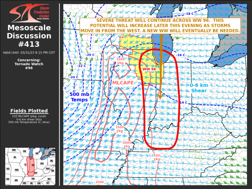
Mesoscale Discussion 0413
   NWS Storm Prediction Center Norman OK
   0620 PM CDT Fri Mar 31 2023

   Areas affected...Eastern Illinois...Far Southeast
   Wisconsin...Western and Central Indiana...Far Southwestern Lower
   Michigan

   Concerning...Tornado Watch 96...

   Valid 312320Z - 010115Z

   The severe weather threat for Tornado Watch 96 continues.

   SUMMARY...A severe threat is expected to be maintained across WW 96
   over the next few hours, and will increase later this evening as
   storms move into the watch from the west. New WW issuance will
   eventually be needed to the east and south of WW 96, from eastern
   Illinois into west-central Indiana southward into western and
   central Kentucky.

   DISCUSSION...The latest WSR-88D radar from Chicago shows scattered
   strong to severe storms located from the central part of WW 96
   eastward into far northern Indiana. This east-to-west corridor is
   located along a warm front extending east-southeastward from a 996
   mb low. Rotating storms that interact with the warm front could
   become tornadic. Otherwise, a wind-damage and large hail threat will
   continue with the stronger cells along and near the front. As the
   exit region of a 90 to 110 knot mid-level jet approaches from the
   southwest early this evening, large-scale ascent and deep-layer
   shear will increase across the lower Ohio Valley. This will make
   conditions increasingly favorable for severe storms. In response,
   intense storm development will become widespread, especially as
   severe line segments move into the area from the west. Tornadoes,
   wind damage and large hail will be likely with the more intense
   cells.

   The severe threat will increase to the east and south of WW 96 later
   this evening, necessitating WW issuance across parts of southeast
   Illinois into western/central Indiana and Kentucky.

   ..Broyles.. 03/31/2023
-
 1
1
-
-
Latest NWS LOT summary graphic, for those intrigued:

-
We continue to see SBCAPE outperformance relative to HRRR 1hr forecasts, this time in northern Illinois (over 1500 j/kg near Rockford currently per SPC mesoanalysis, 17z HRRR forecast for 18z had ~1100 to 1200 at most). Undoubtedly thanks to the aforementioned less aggressive cloud cover.
-
1
-
-
MDT moved eastwards
-
For what it may be worth, appears the latest HRRR is underdoing instability in northern Missouri considerably: latest SPC mesoanalysis shows a pocket of 3000+ j/kg SBCAPE across the area, whereas the HRRR (15z run, showing 16z forecast CAPE) only has it at about 2500 j/kg. Feels like a bit of an abyss.
-
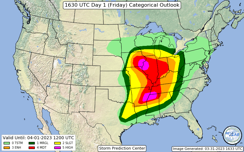
Big question on my mind, does the SPC push the Moderate Risk eastwards given what appears to be better clearing than model guidance expected plus these remarkable short-term models showing at least a couple rotating storms moving thru NE IL.
-
-
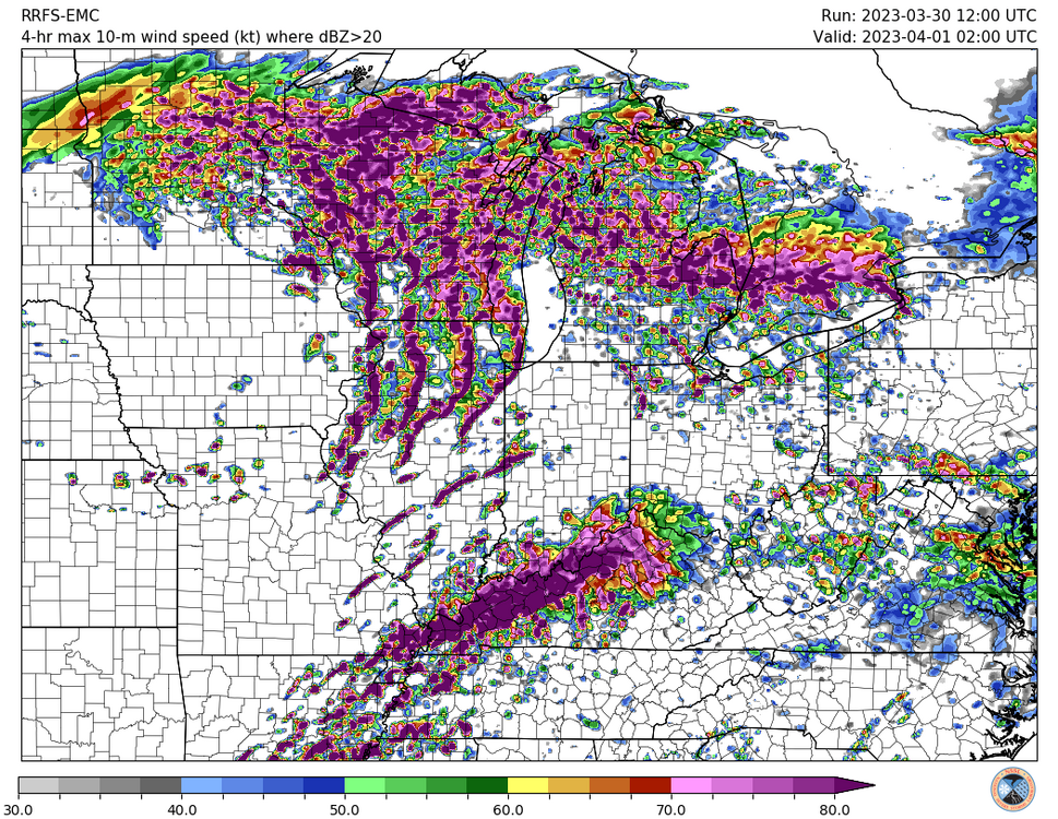
Just don't feel good about the potential for north-central / northeast Illinois. Taking models verbatim, we have potentially widespread, potentially strong storms plowing through the area in the morning hours, almost totally overcast skies through the balance of the day, and yet somehow we still end up with over 1000 j/kg CAPE? I get the very impressive dynamics of the system, including similarly-impressive unstable air advection on northwards, but a daytime high in the area somewhere in the low/mid-60s with extensive cloud cover and substantial early-morning convection never feels very good.
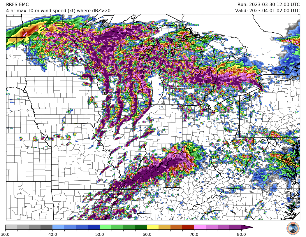
Assuming model guidance is right and I'm dead-wrong (more likely than not), though, I'm super concerned about damaging winds in the Chicagoland area. Storm movement per LOT potentially over 60 MPH plus the aforementioned dynamics of this system lead to some eye-watering images like this ... maximum 4-hour swath 10m winds showing pretty large swaths of >80 knot (~92 MPH) winds with this line. Pretty much a worst-case scenario type of graphic, of course, but does give a sense of what mets & others here have discussed re: significant severe potential.
-
4 hours ago, mimillman said:
Personally I’d rather live in Chicago with 4.7” of snow this season than live in Nebraska getting 12-18” this system.
But that’s just me.
No offense to those of you who live in Nebraska.
Actively preparing to move back to IL from here in eastern Nebraska, I get it
-
Can't be upset at mood flakes this time of year, especially if this time around salt actually will work on the roads as it falls. Bring it
![KOREA KMA [10-KM] Snowfall Snowfall 84.png](https://www.americanwx.com/bb/uploads/monthly_2024_01/753249806_KOREAKMA10-KMSnowfallSnowfall84.png.4f8af08af334ca3f6d21b37c1dd81dc1.png)

![KOREA KMA [10-KM] Snowfall Snowfall 120.png](https://www.americanwx.com/bb/uploads/monthly_2024_01/105549237_KOREAKMA10-KMSnowfallSnowfall120.png.c646e4a1c7518a9c106236f347e73bc2.png)


2/14-2/15 Potential Major Winter Storm
in Lakes/Ohio Valley
Posted
They'll be getting the boats out in Paducah