

Drummer
-
Posts
38 -
Joined
-
Last visited
Content Type
Profiles
Blogs
Forums
American Weather
Media Demo
Store
Gallery
Posts posted by Drummer
-
-
Here we go.
.-
 2
2
-
-
I’d really love for this thing to defy the odds and either fizzle out or curve north faster.
currently at WDW until the 13th. Hopefully minimal impacts. Maybe some easement in the crowds and some ponchos.
-
at what point does the banter thread come into play around here?
-
18
-
 2
2
-
-
2 minutes ago, wncsnow said:
I think it's safe to say we won't be seeing another Ian ever. Have to be getting low on I names at this point.
Maybe just start with the letter B or C to offset the alphabet lol
-
Just now, Eskimo Joe said:
The latest NHC discussion (#24 for future archival) is absolutely worth reading. Eric Blake talks about the worth of the hurricane hunters and Tampa Bay doppler radar. Wish I could post it but I'm mobile.
[quote]
000
WTNT44 KNHC 281458
TCDAT4

Hurricane Ian Discussion Number  24
NWS National Hurricane Center Miami FL       AL092022
1100 AM EDT Wed Sep 28 2022

Air Force Reserve and NOAA Hurricane Hunter data was absolutely
critical this morning in diagnosing the rapid intensification of
Ian, despite both planes undergoing multiple eyewall penetrations
experiencing severe turbulence.  That data supported an intensity of
about 135 kt a few hours ago.  Since that time, high-resolution
Tampa Doppler radar data has been sampling the eyewall near 10,000
ft with winds up to 155 kt, indicating that Ian is on the threshold
of category 5 status.  The maximum winds are set to 135 kt on this
advisory.

Ian is expected to make landfall in southwestern Florida in the next
few hours as a catastrophic hurricane.  No changes were made to the
track forecast near Florida, except to be faster to come into line
with the latest consensus aids.   One important change is that Ian
is likely to remain more intact as it crosses the Florida peninsula
(due to both its stronger initial wind speed and its faster forecast
forward speed), and this now increases the threat of hurricane-force
winds on the east coast of Florida.  This necessitates the issuance
of a Hurricane Warning on the east coast of central Florida.  While
significant re-strengthening of Ian might not occur over the
Atlantic Ocean, model guidance has been catching up with a
trough interaction from a shortwave over the southern United
States, and are stronger than yesterday on Ian's intensity with
more baroclinic forcing.  Thus, a Hurricane Watch has been issued
from northeastern Florida northward up the coast through most of
coastal South Carolina.   The new intensity forecast is raised from
the previous one, near the latest statistical-dynamical guidance.


Key Messages:

1. Catastrophic storm surge inundation of 12 to 18 feet above ground
level along with destructive waves are expected somewhere along the
southwest Florida coastline from Englewood to Bonita Beach,
including Charlotte Harbor. Residents in these areas should urgently
follow any evacuation orders in effect.

2. Catastrophic wind damage is beginning along the southwestern
coast of Florida today near the landfall location.  Hurricane-force
winds are expected to extend well inland along near the core of Ian.
Preparations to protect life and property should be urgently rushed
to completion.

3. Heavy rainfall will spread across the Florida peninsula through
Thursday and reach portions of the Southeast U.S. later this week
and this weekend.  Widespread, life-threatening catastrophic
flooding is expected across portions of central Florida with
considerable flooding in southern Florida, northern Florida,
southeastern Georgia and coastal South Carolina. Widespread,
prolonged major and record river flooding is expected across
central Florida.

4. Hurricane conditions are expected along the east-central Florida
coast overnight, where a Hurricane Warning has been issued.
Hurricane conditions are possible from northeastern Florida to
portions of South Carolina on Thursday and Friday, and a Hurricane
Watch has been issued for that area.


FORECAST POSITIONS AND MAX WINDS

INIT  28/1500Z 26.3N  82.5W  135 KT 155 MPH
 12H  29/0000Z 27.3N  82.1W  105 KT 120 MPH...INLAND
 24H  29/1200Z 28.3N  81.4W   60 KT  70 MPH...INLAND
 36H  30/0000Z 29.3N  80.8W   55 KT  65 MPH...OVER WATER
 48H  30/1200Z 30.8N  80.6W   55 KT  65 MPH...OVER WATER
 60H  01/0000Z 32.9N  80.9W   45 KT  50 MPH...INLAND
 72H  01/1200Z 34.7N  81.5W   30 KT  35 MPH...POST-TROP/EXTRATROP
 96H  02/1200Z 36.0N  81.5W   20 KT  25 MPH...POST-TROP/EXTRATROP
120H  03/1200Z...DISSIPATED

$$
Forecaster Blake
[/quote]
-
2
-
2
-
-
-
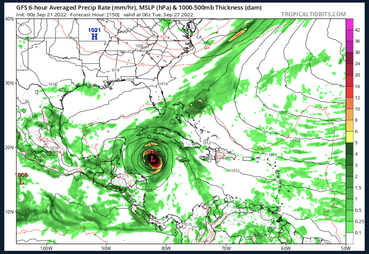
Seems like it might get cheese-grated over Hispanola on that track.
-
9 minutes ago, Witness Protection Program said:
LOL. "Of course I don't want anyone to get hurt, but I get real excited at the possibility of someone shooting a gun into a coastal crowd", posted from a state safely far away....
Do we have to do this?
-
4
-
-
3 minutes ago, WxWatcher007 said:
Not accurate. The main thing is that the ensembles are trying to show a pathway for TC genesis that could get into the Caribbean.
I posted the Papin tweet in the thread but this is a great illustration of what we’re looking at. This isn’t ten days out there either, this is a short to medium range forecast. For genesis—don’t really care about the downstream impact—that’s too early.
Thanks. Thought it looked kinda funky after watching the model run.
-
14 minutes ago, Seminole said:
This should grab some folks attention.

ignoring any issues with initializing (haven't ran it myself), how accurate is this at 240hrs+?
-
3 hours ago, CheeselandSkies said:
How's that 0/0/0 August looking, @ldub23?
Great, you jinxed it.
-
 2
2
-
-
6 minutes ago, Prospero said:
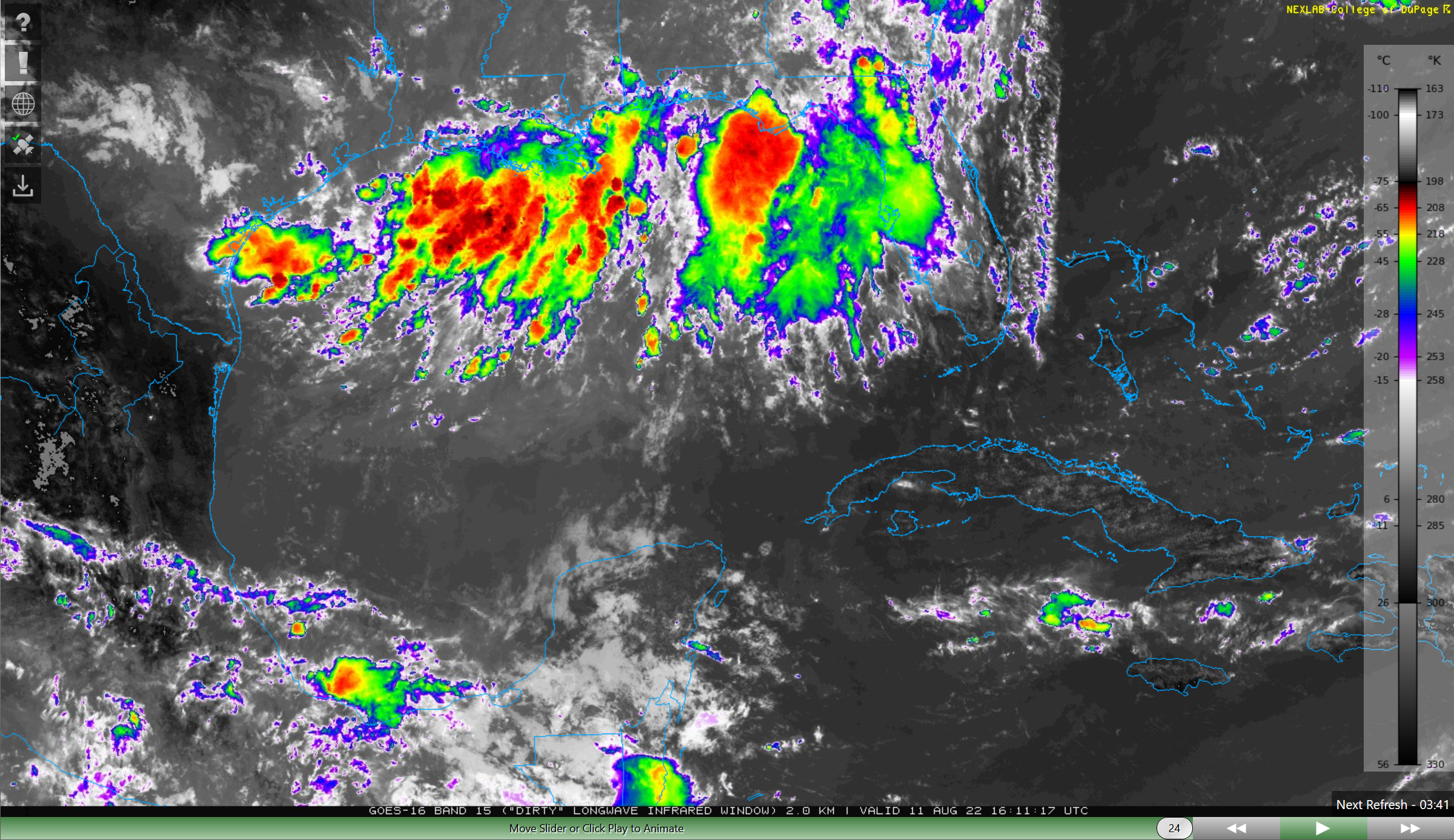
I went to bed last night leaving some things outside with a very low chance of rain for Tampa Bay. I woke up at 2:20 AM to thunder and checked radar on my phone, got up and got everything inside just in time. I woke up again at 5:00 am to a second thunderstorm. Now I am looking at sats and waiting for a surprise system to form in the northern GOM today or tomorrow...
")


-
Even I, someone who wasn't gifted with much intelligence, knows not to call the season a "bust" or "boring" in early August.
-
2
-
-
Very light snow falling in Lake Wylie
-
Just now, Avdave said:
Major winter storm in the Triangle? What is she looking at? Maybe for Elizabeth City.
Carova, IMO.
-
3
-
-
1 minute ago, KyleEverett said:
In Charlotte, it seems to be Mount Holly in Gaston County as the bulk of it. I'm really surprised York County south of Charlotte doesn't have more with as much ice accretion we have so far.
It’s been SleetFest 2022 here in Clover.
-
5 minutes ago, NCSU_Pi said:
I realize this a dumb layman's question, but does the eruption of that volcano introduce any appreciable element of chaos on our forecast?
Pretty sure it’s too far away.
-
Sirens going off in the Lake Wylie/Steele Creek area. Not sure if it's from Catawba Nuclear or if those towns have their own.
-
29 minutes ago, Drummer said:
I'm in York, looks like I'm about to get the part that was previously tor warned. Can't really leave the room since I'm self quaranting (covid positive, but mild case). Day started off pretty cool, cloudy, foggy, but I noticed the sun peeking through early afternoon before these clouds rolled in. Temps have been mid/high 60s since, dewpoints in the 60s as well. Getting a little breezy. Not as worried as I was late last night but a little more worried than I was when I woke up. Hopefully it won't be much, but we'll see what she's got. Will be interested in seeing what comes after it crosses through the CLT metro.
Not too bad, came and went pretty quickly. Our house overlooks Nanny Mountain (more of a glorified hill if you ask me), but it was pretty cool seeing it get engulfed in the rain. Oddly no wind here, especially odd considering the tor warning just popped when it was maybe 1-2mi east of us. Just heavy rain and pea-sized hail.
-
I'm in York, looks like I'm about to get the part that was previously tor warned. Can't really leave the room since I'm self quaranting (covid positive, but mild case). Day started off pretty cool, cloudy, foggy, but I noticed the sun peeking through early afternoon before these clouds rolled in. Temps have been mid/high 60s since, dewpoints in the 60s as well. Getting a little breezy. Not as worried as I was late last night but a little more worried than I was when I woke up. Hopefully it won't be much, but we'll see what she's got. Will be interested in seeing what comes after it crosses through the CLT metro.
-
-
2 minutes ago, brianc33710 said:
Did this image come through for anyone else?
nope.
-
-
Mostly snow falling now. Closest weather station 1mi away says 33.2F with 15F dewpoint.
Tropical Storm Bret
in Tropical Headquarters
Posted
RIPIP
.