

Tekken_Guy
-
Posts
138 -
Joined
-
Last visited
Content Type
Profiles
Blogs
Forums
American Weather
Media Demo
Store
Gallery
Posts posted by Tekken_Guy
-
-
23 minutes ago, bluewave said:
Beyond the general idea that this week will be warmer than next week, week 3 is always very uncertain. So I will delete the maps beyond day 15.
At what point did this week’s warmth first show up on the forecasts? And when did the cooldown first show up as well?
-
12 minutes ago, bluewave said:
The maps that I posted showed the cooler departures moderating after next week. The means are rapidly rising during this time of year. So average high in NYC is in the upper 60s by the end of April.
Sorry I must have misinterpreted you as saying this is the only warmth we’re getting at all for the month, rather than just “the warmest”. To be fair, what’s 20 degrees above normal now may be only 10 degrees above by the end of April.
Even if we don’t get another 80 I could see us easily getting some mid-70’s by the end of April.
-
2 minutes ago, bluewave said:
You are arguing a point that nobody made. The warm parts of the area will reach 80° or warmer this week. So if the blocking continues into late April, then we’ll have to wait until May to see 80° again.
Sorry. I was using 70 as my threshold, not 80.
My point still stands that there is nothing suggesting the cool pattern for next week will stick around for any more than just next week.
-
Well right now there are no indicators that next week’s cold will last into the final week of the month.
I’ll be willing to bet on it.
If it does not hit 70 degrees at KCDW even once on any of the next three Mondays or Thursdays, starting with 4/18 and ending on 5/5, I will not post here again until after Labor Day.
-
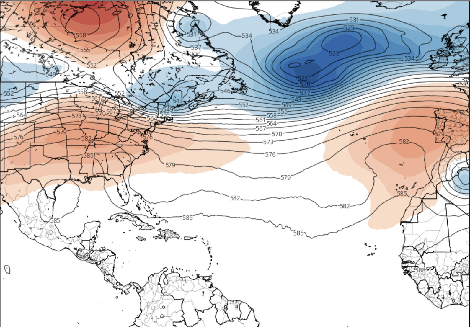
7 minutes ago, bluewave said:
Beyond week 2 is always lower skill. But the EPS has a -AO +PNA pattern. So the high temperatures for this week may be the warmest of the month.
EPSApr 18-25

Apr 25-May 2

What is causing this pattern exactly?
-
1 hour ago, bluewave said:
This could be the warmest week of the month if the EPS is correct about the blocking returning for late April.
EPS
Apr 11-18

Apr 18-25

Apr 25 -May 2

From what that looks like, the blocking seems to only be there for next week. So that 4/25-5/2 period looks nowhere near as cold as the 4/18-4/24.
I’ve been looking at the GFS and they’ve been very consistent with hinting the warmth could come back for the last week of the month.
-
The latest 18z GFS shows goes back to full blast on the Thursday warmth with low cloud coverage virtually nonexistent in the forecast. 79 is the warmest the forecast has shown for the short term since Friday's 18z, which also hit 79 for Thursday.
On the other hand, we have a 10+ day streak of sub-70s (plus a 7-day streak of sub-60s) starting the day after Easter. The post-Easter peak is 65 on Sunday the 24th, which is also the lowest post-Easter maximum high the model has forecast since also the Friday 18z in which the 23rd also hit 65.
-
 1
1
-
-
It’s early, but there are signs that after the cooldown in Week 3 the last week of April might be warm again.

-
2 minutes ago, nycwinter said:
last day of may temps are in low 70's not the beginning of the month..
Here in Caldwell, the average high for May 1 is just shy of 70 percent so it’s far from unusual for the highs to reach the 70s on any day in May.
By the end of the month the average high is 76, so “low 70s” is actually rather cool for May 31.
-
17 minutes ago, SnoSki14 said:
Yup it's coming
Yesterday it looked like Thursday would peak in the 60s. What changed?
-
1
-
-
34 minutes ago, Wxoutlooksblog said:
I am skeptical. There is too much energy in the upper atmosphere to allow it with little if any sustained heat source. There will be lots of showers and thunderstorms in the warmer air for any brief period of time we're in it. Lots of cold air aloft. The atmosphere will destabilize quickly with any daytime heating. We might eke out a 78 one day.
WX/PT
What exactly needs to happen for a warm pattern to sustain itself?
-
Mondays and Thursdays are by far the most important days for me on the forecast, given that's when I go to classes. There's also Wednesdays but I'm usually just there for a morning class and out so it's considerably less important to me.
-
30 minutes ago, SnoSki14 said:
Despite all this "blocking" I'm still willing to bet we score another AN month.
I'm gonna guess some places hit 80F next week on one or more days
GFS is an outlier with a very warm Thursday. They're going all in on no low clouds to block the warmup.
Other models have the warmth peaking on Tuesday in the low 70s.
The 2nd half of April would have to resemble 2020's to get to BN.
-
18z GFS update. The Thursday clouds are gone and the forecast surges back to the 80s.
But the week after is the coldest the model’s forecasted in quite some time.
-
1
-
-
20 minutes ago, bluewave said:
It looks like we could see 70s on Tuesday with the warm downslope flow. Then a possible backdoor for Wednesday. This is followed by a warm front for Thursday.


Hard to call Thursday a "warm" day in that scenario. The models virtually all have given up on any warmth on Thursday as clouds are starting to get in the way, and Wednesday's looking increasingly unlikely to be warm as well. Still a shot for Tuesday though.
-
5 hours ago, bluewave said:
Fast pattern changes coming up on the models. Cool weekend is followed by a brief warm up next week. Then the blocking returns for a cooler week 2. So a stormy pattern for the US with a clash of air masses. Looks like the CONUS is already off to the fastest start to the spring tornado season in the Doppler era with the big temperature swings.
EPS
Apr 11-18

Apr 18-25

I'm getting different signals from the other models. Next week doesn't look like it'll be as warm as it did in the models released earlier in the week. On the other hand Week 3 doesn't look like it'll be as cold as this week was.
-
24 minutes ago, jm1220 said:
Depends on how far the storm over the weekend can clear east of us. If it gets stuck over the Maritimes and heights stay low there, good chance there will be a backdoor front nearby. It'll encourage a high to develop NE of Maine and easterly flow. If it heads east and there's no blocking, we'll get the nice westerly flow for a day or two. Looks short lived unfortunately.
Over/under on whether or not April is a below or above normal month temperature wise?
-
Is April likelier to be above or below normal?
-
3 hours ago, jm1220 said:
Hopefully we can get the ridging to the east of us somewhat. That EPS look screams back door fronts when it does get mild.
What exactly was the pattern that gave us March 2012 or April 2010?
-
1
-
-
6 minutes ago, SnoSki14 said:
I see blocking for early April but not sure what happens after.
I’m just hoping we don’t get a repeat of 2020 or 2018 in April.
-
59 minutes ago, snowman19 said:
There are some signs that April may end up being a lot warmer than some people think right now. I don’t think it ends up anything like last April. I also think we start torching in May
What happened last April?
-
The latest GFS model (18z) shows nothing past 58 degrees following this weekend’s warmup. And the last week is pretty much all negative temperatures on the 850 hPa.
-
 1
1
-
-
5 hours ago, White Gorilla said:
Is this warm pattern projected to last the test of the Spring? I am perfectly OK with it.
On the latest GFS for Caldwell, after this Friday and Saturday, the only other reasonably warm day on the horizon is next Saturday. There have only been a few scattered “warm days” in the last several GFS models and they’ve only been popping up on Fridays and weekends.
-
1
-
-
18 minutes ago, donsutherland1 said:
A weak cold front will move across the region tomorrow. Behind it, Thursday will turn somewhat cooler.
And why will Friday be warmer?


April 2022
in New York City Metro
Posted
Going solely by Mondays and Thursdays (my main campus days), there are some promising signs the warmth will return. While Monday’s out of the picture, next Thursday has a (very slim) shot at being warm again. Getting into the mid 60s on Thursday I think is actually a realistic scenario, though.
For the week after, Monday the 25th is showing some promising signs. The 28th though, not so much (though that date hasn’t gotten into the ECMWF forecast yet).