

Tekken_Guy
-
Posts
138 -
Joined
-
Last visited
Content Type
Profiles
Blogs
Forums
American Weather
Media Demo
Store
Gallery
Posts posted by Tekken_Guy
-
-
21 hours ago, Wxoutlooksblog said:
I don't see any sign of it. Could the cooler than normal break for one or two days? Sure. But I think it would be for a one day shot of near normal". I see no sign whatsoever of a ridge in the east which is necessary for prolonged above average temperatures. For that I think at the earliest late in the third week of May--17th-24th....at the earliest. At the latest second week of June.
WX/PT
Does that mean May is likely to be below normal, or possibly cooler than April?
-
 1
1
-
-
12 hours ago, Wxoutlooksblog said:
I anticipate at this point that any return to above normal temperatures for the NYC Metro region would probably occur late during the 3rd week or 4th week of May. We might get into near normal temperatures a few days to a week before then.
WX/PT
I’m cautiously optimistic we’ll be warm again in Week 2 of May. If we’re lucky the pattern will break by next Thursday.
-
6 minutes ago, Superstorm said:
Don't we do this every year?
Yeah this is typical. Last year April 14 was almost a 90-degree day. Didn’t crack 80 again for a month, or even 75 for three weeks.
Warm-ups this time of year are usually very fleeting. Cooldowns on the other hand generally last much longer.
-
1
-
-
1 hour ago, CIK62 said:
The last 6 days of April are averaging 55degs.(49/62) or -3.
Month to date is 58.9[+6.3]. April should end at 58.1[+4.4], 1st. Place.
Reached 61 here yesterday at 4pm.
Today: 60-63, wind nw. to sw., p.sunny-clouds late, 49 tomorrow AM.
48*(58%RH) here at 7am. 50* at 8am.
Is it possible we fall slightly below the record of 2010?
-
1
-
-
As of right now, I’m sensing that we move out the BN range sometime around May 4-5.
-
1
-
-
1 hour ago, GaWx said:
Per two regular posters April is headed to ~58, warmest on record. NYC Mays have been colder than 58 six times since 1870 or once every 25 years. That implies ~4% chance. However, the last one was way back in 1967 during a colder climate. Also, each of those six sub 58 Mays followed a BN to NN April as the six preceding Aprils were 46.9-49.6. This all tells me that the true chance for next month being colder than 58 without knowing how May would start is probably <4%. With May progged to start off BN, I'd raise the chance back up some though probably not above 5% considering our warmer climate.
The BN pattern in May could last like 3 days before shifting to more seasonal. I can’t see this holding for more than two weeks.
-
2 hours ago, SnoSki14 said:
Looks like weeklies/monthlies actually shows a BN May after a record warm April.
Has May ever had a lower average temperature than April?

-
1
-
 1
1
-
-
5 hours ago, CIK62 said:
The next 8 days are averaging 57degs.(49/64) or -1.
Month to date is 59.0[+7.2]. Should be 58.4[+4.8] by the 29th.
Reached 60 here yesterday at 5pm.
Today: 64-69, wind e., variable clouds-increasing, 55 tomorrow AM.
Near Normal rest of month and a BN 1st Week of May:

52*(78%RH) here at 7am. 58* at 9am. 61* at Noon. 63* at 2pm.
I think you got that backwards. Next week will be the big cooldown and it returns to normal as May arrives.
-
7 minutes ago, Brian5671 said:
East winds. Started showing up on models a couple days ago.
Meanwhile the Euro is showing a couple of wet solutions especially east of NYC for Sat night/Sun

I'm starting to get the feeling we might not break the record for warmest April. Next week could shave 2-4 degrees off the average and tomorrow was supposed to provide a buffer.
-
Wasn't it supposed to hit 80 tomorrow?
-
15 minutes ago, Wxoutlooksblog said:
An onshore flow will keep temperatures cooler than previously expected today, tomorrow, and Saturday with 70s to near 80 only over some spots well inland well north west and northeast of NYC as our temperatures stay mainly in the 50s and 60s.
WX/PT
We likely needed that warm day to lock in the warmest April record. Now there’s a very strong chance 2010 keeps it, especially if it stays below 60 for most of next week.
-
1
-
-
23 minutes ago, Wxoutlooksblog said:
Actually there was. Almost every GFS operational run then CMC and Euro showed it clearly. In April when you get 564dm thicknesses here on light northwesterly winds or light variable winds and no moisture around you're going to be above normal.
WX/PT
There’s really no consensus on what’s going to happen past the 19th. The Euro ensembles show everything all over the place the following four days. And it’s way too early to make any predictions on anything in the last week of April.

-
1
-
-
7 minutes ago, Wxoutlooksblog said:
EPS is right about normal. I'm really not at this point seeing ensemble maps that would support above normal temperatures for the last 8 or 9 days of April.
WX/PT
Probably because it’s too early to make any forecast as to what the final week of April will look like. I mean two weeks ago there was no sign of any warmth for this upcoming week.
-
7 hours ago, Wxoutlooksblog said:
I think that this month may not end up in the top ten warmest Aprils. It looks to me like the NYC Metro Region has two very above normal days then a little less above normal for a day or two then probably near to perhaps slightly below normal normal for the rest of the month and kind of wet. My thinking is that we might have to wait several weeks before we get into more above normal temperatures again, sometime around mid May. But Thursday & Friday this week could be mid-upper 80s with a chance that somebody hits 90.
WX/PT
That’s exactly what happened last April. Anyway, models are suggesting that the cool-off peaks around the 19th then it trends warmer again.
-
Apparently my last day of classes is now the 9th instead of the 5th. So I get an extra day on my bet.
-
29 minutes ago, CIK62 said:
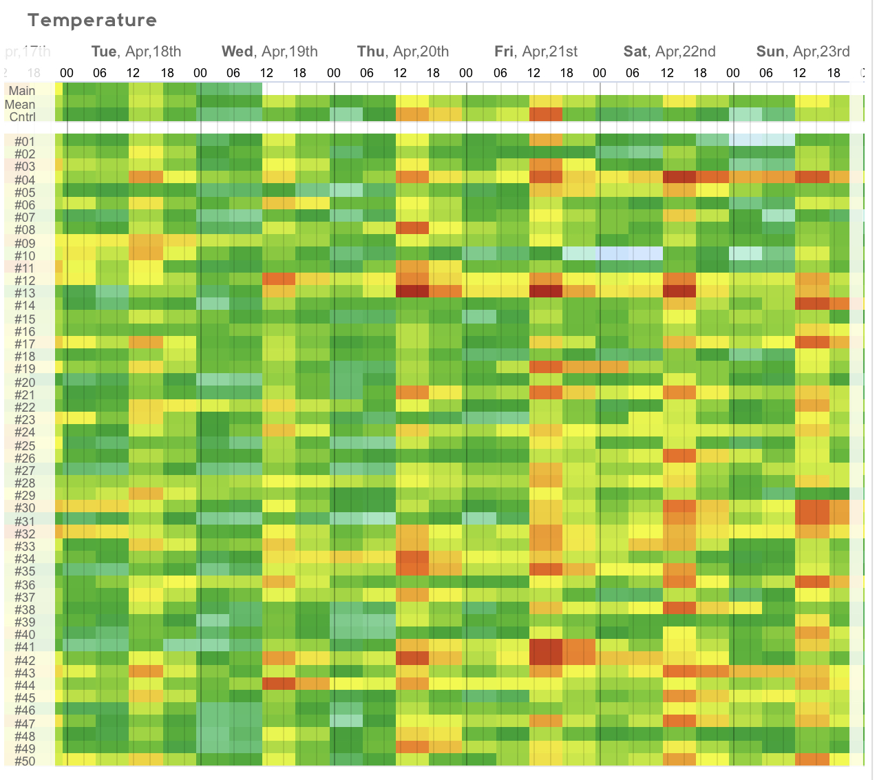
In trying to place the BDCF the EURO is the coolest (but maybe not COOL). For Sunday the GFS has an astounding 83!.
Look here however.................

What's the status for Monday and Tuesday? I've seem some conflicting reports on whether or not it heats up.
-
OK. 4/25. 4/28, 5/2, and 5/5 are my last days on campus (other than Finals). Can I get a 70 at least once?
-
1 minute ago, SnoSki14 said:
The blocking is actually just getting started late April. The NAO/AO is only now dropping.
The weather could still be nice but don't expect very warm weather anytime soon next 2-3 weeks min.
What’s the deal with my bet? Will I get any warm Mondays and Thursdays before the semester ends on the 5th?
-
00z GFS is out and once again has me going 0-6 on 70+ Mondays and Thursdays.
-
1
-
 2
2
-
-
1 hour ago, bluewave said:
Friday may be the best chance for NYC and Newark to make a run on 70° for a while. The SE Ridge duels with the -AO block over the next week. So backdoor cold fronts will come into play. Very sharp gradient for us over the weekend. The area around NYC could stay in the 60s with 70s and 80s to the west on Sunday.The EPS has an unusually strong block from Greenland to Alaska from late April into early May. This will favor a trough of low pressure in the Northeast. There could be some late season freezes for the interior parts of the region.


Apr 18-25
Apr 25-May 2

What about Monday 4/25? Friday doesn't count towards whether or not I have to leave the forum after 5/5. Monday will.
4/21, 4/25, 4/28, 5/2, and 5/5 are the five days left. If KCDW hits 70 degrees just once, I stay. Otherwise I'm leaving for the summer.
-
12z GFS has a Mon/Thu peak of 60 for this Thursday. Looks like I may actually have to leave AW for the summer.
-
1 hour ago, Wxoutlooksblog said:
It's a very bad pattern. I think we'll hit 70 late this week, maybe even 75 or 78 but after next weekend, we're going to be below normal temps and near normal precip for a while IMO. I don't think Central Park is going to get to 80 this month. Though we should see much more warmth possibly heat starting around mid or late May.
WX/PT
I anticipate we’ll fall short on Friday. I do think we have a shot for the beginning of next week, though. If we get it on the 25th I win my bet. The end of that week looks on the cool side, though.
-
Quote
If it does not hit 70 degrees at KCDW even once on any of the next three Mondays or Thursdays, starting with 4/18 and ending on 5/5, I will not post here again until after Labor Day.
If that 12z GFS is true then I'm in big danger of losing my bet.
-
2 hours ago, SnoSki14 said:
In about a month or so it'll be 80+ everyday for the next 4 months. Summer is just around the corner
My college semester ends on May 5 though (aside from a couple of finals). I just want the warmth to be there by then.
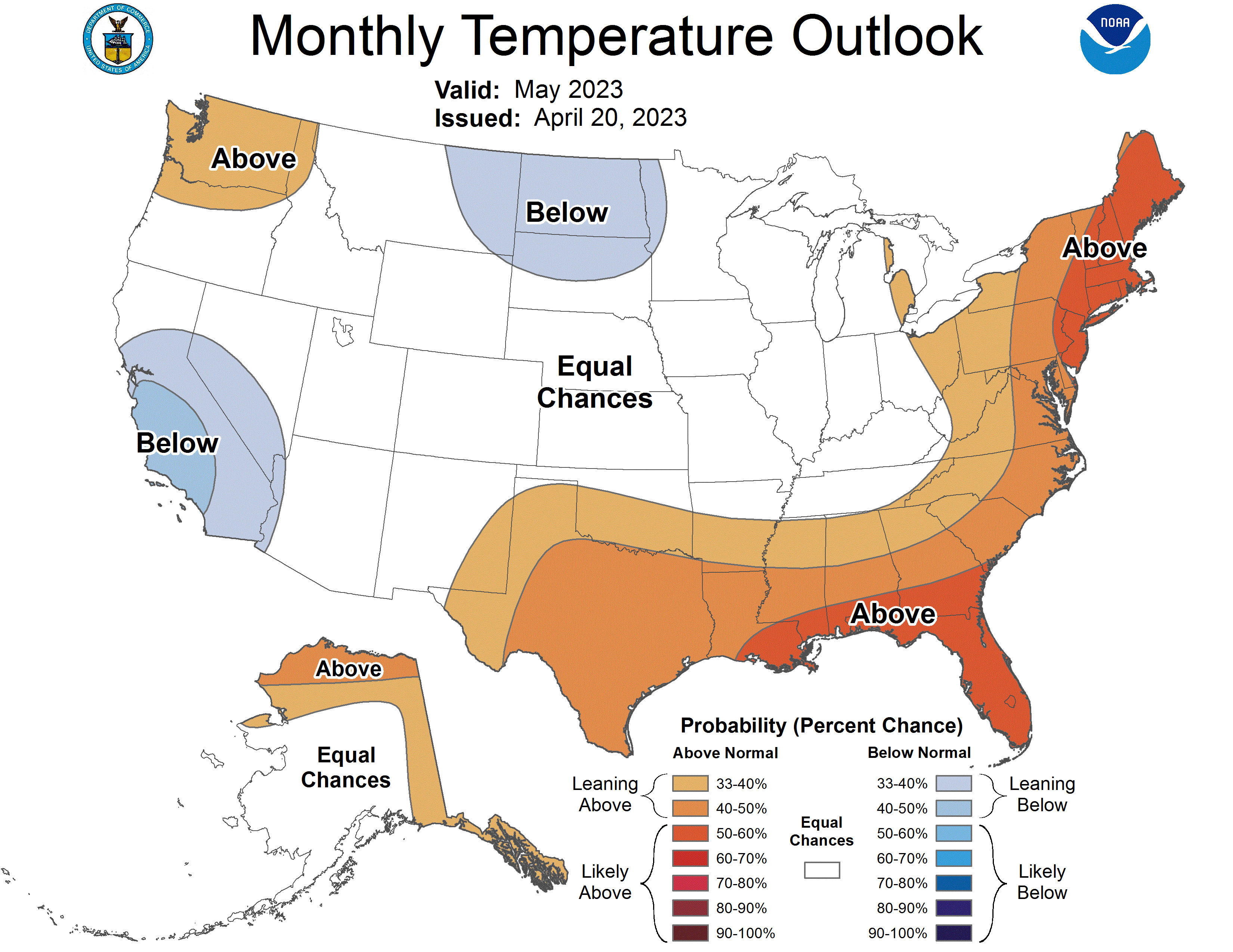


May 2023
in New York City Metro
Posted
I am not seeing any evidence of another cooldown next week.