
AWMT30
-
Posts
277 -
Joined
-
Last visited
Content Type
Profiles
Blogs
Forums
American Weather
Media Demo
Store
Gallery
Posts posted by AWMT30
-
-
Going to be a crazy forecast going forward, you want to give the lean to the GFS but can not discount the Euro.
-
GEFS look to hold as well.
-
 1
1
-
-
GFS said enough with the shifts south
-
1
-
-
Detroit crushed one can dream!
-
3
-
-
I will take the CMC please

-
3
-
-
3 minutes ago, DJln491 said:
Excuse the newbness but are these run times accurate?
All times EST
GFS (out to 384 hours)
0z: 10:30pm
6z: 4:30am
12z: 10:30am
18z: 4:30pm
NAM (out to 84 hours)
0z: 8:35pm
6z: 2:35am
12z: 8:35am
18z: 2:35pm
CMC (out to 180 hours)
0z: 12:00am
12z : 12:00pm
UKMET (out to 72 hours)
0z: 12:30am
12z: 12:30pm
ECMWF (EURO) (out to 240 hours)
0z: 1:30am
12z: 1:30pmEuro rolls at 1245 am/pm
CMC rolls around 1130am/pm
Ukie Rolls around 1145am/pm
other than that you are correct on the model times for the GFS and NAM
-
1
-
 1
1
-
-
Will be very interested for the 00z runs tonight especially for Lower Michigan. You would hope the NWS offices here do the right thing tomorrow if trends stay like they are.
-
1
-
-
4 minutes ago, Natester said:
ICON still south, a bit more south than last run. Toss.
ICON chasing the southern convection with the LP no need to worry.
-
The GFS shockingly has done well lately
-
I would really like a nice hit here in SE MI. Being that I do snow removal it will be nice to enjoy a storm here as snow contracts ended the 15th
-
Just now, MIstorm97 said:
Straight up buried
Cheeks Clapped!
-
 1
1
-
-
That was a great HRRR run for SE MI widespread 12"+
-
1
-
-
Just now, Frog Town said:
kind of what I was afraid of. Darn. Can you see that in a Water Vapor? Just love to learn
TY
Yep you sure can see that in the Wv. Other than that things look outstanding going forward. Prepared 2 be buried
-
1
-
-
1 minute ago, Frog Town said:
Do you all thing that batch of snow is central Illinois will hold together as it heads northeast?? would be another bonus inch for much of us if it does. Plus it's our second course to our 3 course meal.
My wife calls this my "Super Bowl". At least i'm not alone
Lost its moisture feed should start to die down here soon and weaken as it moves NE
-
1 minute ago, Frog Town said:
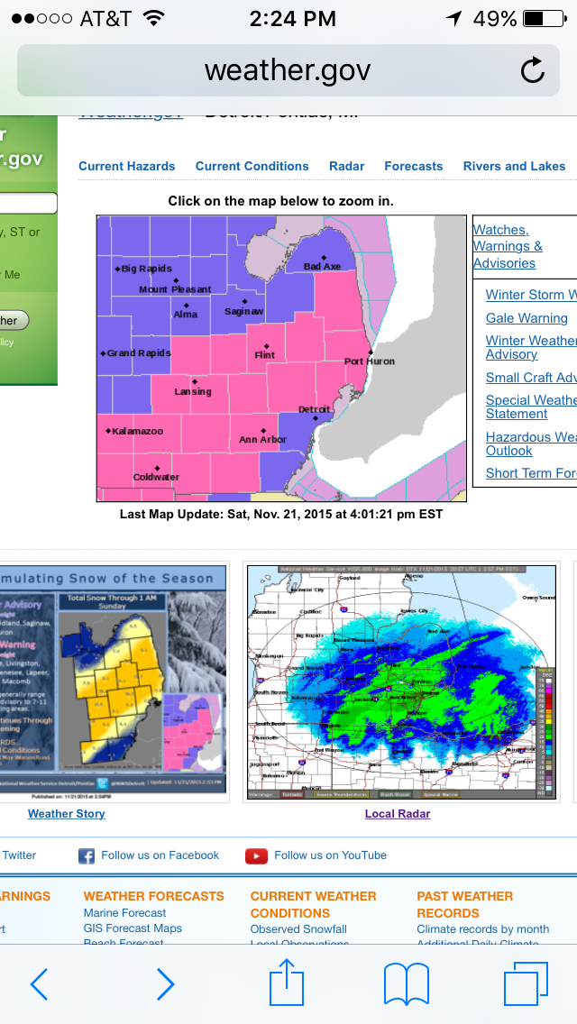
For those in SE MI, it's mind boggling how DTX wont issue warnings, especially when thier own graphics and grids clearly depict a high impact event(during two commutes). Lucas county(Toledo) is often treated this way by CLE. They definitely tread their periphery differently. See for yourself. Those two counties to the south have a WWA.
They are issuing a warning later this morning according to their AFD
-
3 minutes ago, RobertSul said:
Which ones are you seeing this on?
RAP and HRRR
-
1
-
-
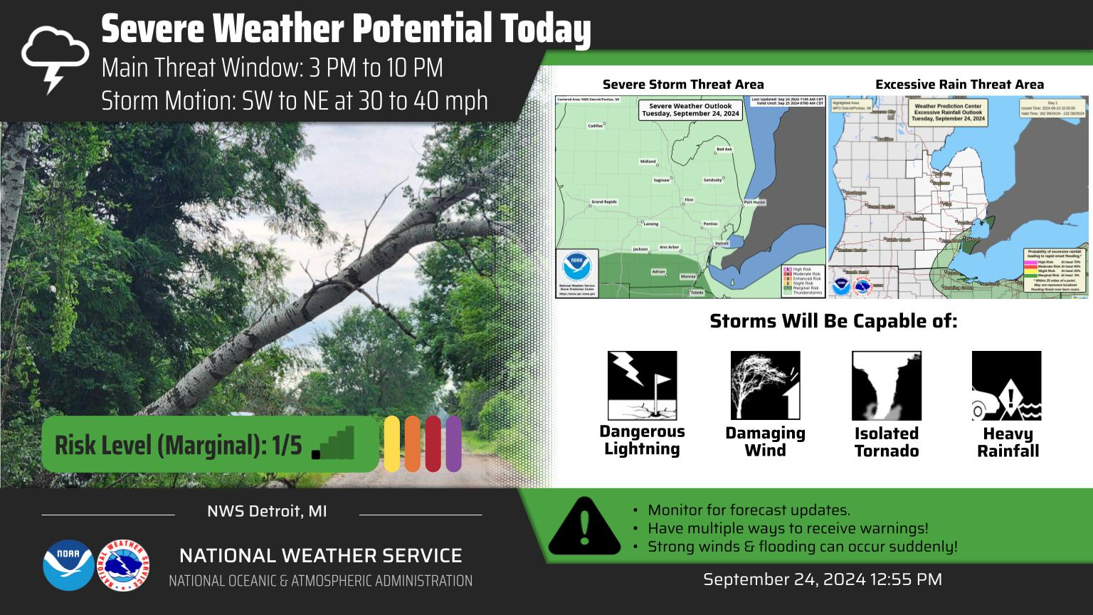
Getting very close to legit blizzard conditions on the models from TOL to DTW
-
1
-
-
Just now, Stevo6899 said:
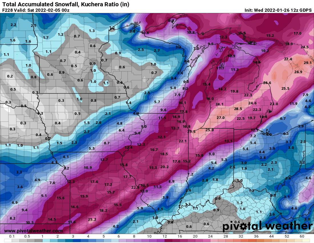
Im sure we wouldn't mind if you generously posted the weenie kuchera for this. Thanks in advance.
It is 12-15" for Detroit
-
6z euro is ticking NW
-
1
-
-
1 minute ago, Stevo6899 said:
Yea been down here since nov 1st. The weathers been so nice. Its rained 3 days since then and above avg temps in the 80s everyday during this arctic intrusion the past 7 days up north. Ive been really rooting for y'all up there all winter. Hopefully this storm or the next one can deliver finally for ya. Good luck.
Thanks we are trying to reel this one in. Especially Josh and myself! Miss you on the chat on FB man! Be well!
-
1
-
-
Just now, Stevo6899 said:
Down in florida until mid march. Tbh I dont think this will be more than 3-5 in SEMI.
Nice man! Hope you are enjoying it down there ya prick haha
-
1 minute ago, Stevo6899 said:
Lol @ nam having some of the higher totals in the area in nw ohio that has no advisories currently.
Are you home right now?
-
LET'S GO!!
-
1
-
-
CMC says nope LOL. GFS is great eye candy.. Although I am concerned about that HP to the NW
Feb 1 -3 GHD III
in Lakes/Ohio Valley
Posted
The GFS will not budge nor will it's ENS crazy battle.