
AWMT30
-
Posts
277 -
Joined
-
Last visited
Content Type
Profiles
Blogs
Forums
American Weather
Media Demo
Store
Gallery
Posts posted by AWMT30
-
-
I will take the HRRR trends
-
 1
1
-
-
Decent plumes for the Chicago Weens, while the plumes for us Detroit Weens dropped..
-
The latest 00z RGEM with a tick north.
-
4 minutes ago, sbnwx85 said:
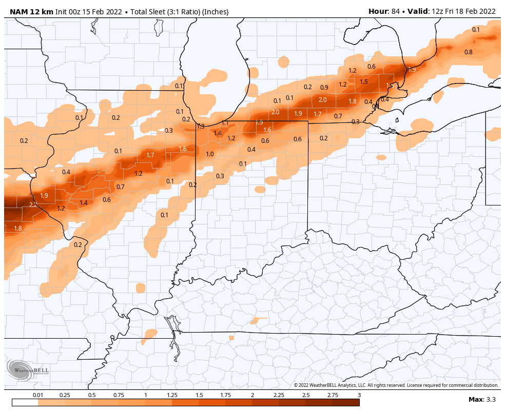
Can’t believe I’m asking this…but anyone have access to sleet accumulation maps?

-
 1
1
-
-
1 minute ago, Thundersnow12 said:
If you're talking about GHD III that's a no. The RAP had multiple runs of 12-18" for the Chi metro area. It like the HRRR was too far NW for multiple runs.
It nailed it pretty darn good for the Lansing area and to my NW
-
And the RAP did quite well once we got inside 51 hours.
-
11 minutes ago, WestMichigan said:
18z NAM almost whiffs Detroit, easy toss.
We get 2-3" of sleet here in Canton on the NAM kind of would want to see that happen
-
 1
1
-
 1
1
-
-
-
3 minutes ago, SolidIcewx said:
I’m feeling a good ice storm here in DTW. As for how much not sure
No thanks I will take ether 2-3" of sleet like the NAM says or 6-10" like the Euro says. Screw Ice
-
2
-
-
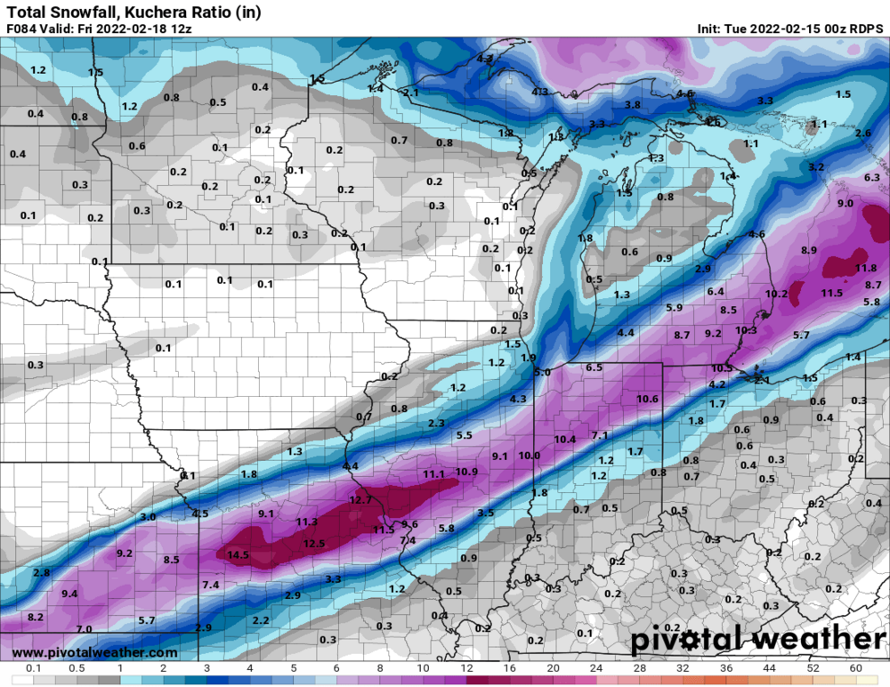
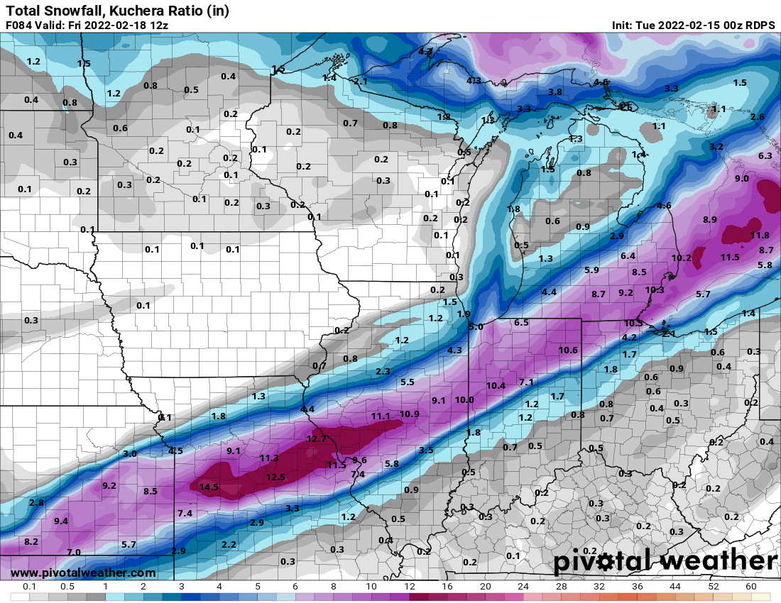
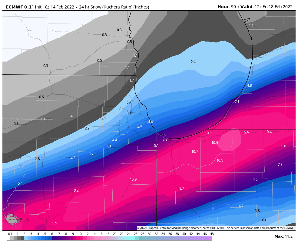
I guess GRR Meteorologist wanted to be done with the day early this is a bland AFD.


LATEST UPDATE...
Discussion/Marine/Hydro

.DISCUSSION...(This evening through next Monday)
Issued at 256 PM EST Mon Feb 14 2022

- Lake enhanced snow tapers off this evening

Expect about another half inch to inch of snow this evening near
Lake Michigan before subsidence associated with surface and upper
ridging moves in and puts an end to the activity shortly after
midnight.

- Mid-week storm

Attention continues to focus on forecast details indicated by
ensemble trends for Wednesday-Thursday. The best bet at this point
is to find a middle ground between the GFS and ECMWF precip
totals, which currently would translate to rain amounts of 0.5 to
0.75 Wednesday followed by 6 to 10 inches of snow on Thursday.
The GFS mean is closer to 10 inches, while the ECMWF is around 6
inches, with the higher amounts displaced further south than the
GFS, although the 12Z ECMWF has trended a bit closer to the GFS.

There is also a signal for some icing during the transition from
rain to snow Wednesday night, but details on this are inherently
even lower confidence than snow totals.

In summary, the potential for snowfall greater than 5 inches
across much of the forecast area between Wednesday night and
Thursday evening may be increasing.
-
1
-
-
Yeah liking Chicago to Detroit for Sig Impacts.
-
Absolutely got whiffed yesterday as well IMBY. Quite depressed about it seeing as Livonia got smoked. Literally there was a snow hole over my house on radar yesterday. Only got a dusting. Very impressive set up for those that got snow.
-
1
-
1
-
-
11 minutes ago, Frog Town said:
This storm has a similar look and feel to one that affected the region back in 2010. Here in SE Michigan the forecast was for 50 degree temps rain just days prior. It ended up turning into an ice storm that crippled the region with heavy snow just in mid Michigan and NW. Anyone else remember that one?? It was Presidents Day weekend.
I totally remember that one. Was suppose to get 2-5" followed by freezing rain. Ended up with 11" of snow and zero freezing rain as it was south of 94.
-
2
-
-
Canton represent baby!!! LOL
-
Moderate snow in Canton, Michigan
-
1
-
-
Just now, SolidIcewx said:
I live in Canton and a lot of my yard is still very frozen even with warm temps suprisingly. Thin layer in sun areas thawed won’t take much to freeze over unless we get a good amount of rain
I live in North Canton
-
HRRR looking like RGEM......
-
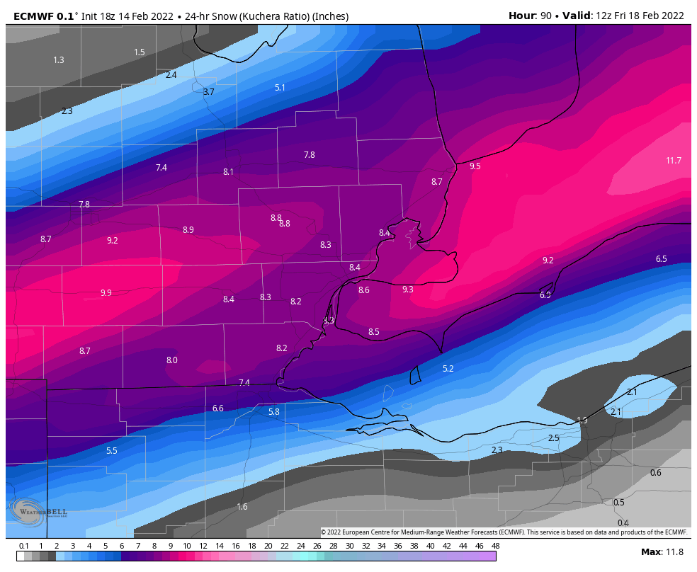
Euro still pretty good for the Detroit Metro!
-
1
-
-
16 minutes ago, Powerball said:
I understand WDIV doesn't even have a chief meteorologists right now, since Ben Bailey left over the vaccine mandate.
I had no idea that's why he left.. Such a shame he was pretty darn good.
-
1
-
-
22 minutes ago, Powerball said:
Honestly, I think the other Detroit area members can attest that none of the Detroit TV meteorologists are that great.
Dave Rexroth (ABC affiliate) is probably the best of the bunch.
Full truth Rexy is the only good Chief we got here in the Detroit Market the rest are not so great..
-
1
-
-
Unreal what these models are putting out.
-
1 minute ago, michsnowfreak said:
Actually we did have double digits, 11" at Detroit. I don't even recall what models were forecasting because that Winter was just one big weather orgasm of fun.
They were going with 12-15" I remember making a map for that one.
-
2
-
-
Euro Ens are SE with the 2nd wave
-
Feb 16-17th Winter Storm
in Lakes/Ohio Valley
Posted
Ohio always out of the game lol