RIC Airport
-
Posts
2,586 -
Joined
-
Last visited
Content Type
Profiles
Blogs
Forums
American Weather
Media Demo
Store
Gallery
Everything posted by RIC Airport
-
KRIC 091654Z 01012KT 1/4SM R34/2800V3500FT +SN FZFG BKN007 OVC011 M01/M03 A3030 RMK AO2 SLP268 SNINCR 1/2 P0008 T10111028
-
+SN now officially at RIC
-
The roads here are getting covered now.
-
KPHF has been changing back and forth between rain and snow since about 9 am.
-
Coming down good in Williamsburg. Everything is white except the roads, this is a lot more than I expected here, to be honest. I am not even under an advisory.
-
Closest SLEET I can find is along the border around Emporia. RDU officially switched over last hour.
-
Steady snow here in Williamsburg. Just above freezing at the surface, so only sticking to colder surfaces. It is, however, the heaviest of the day so far. I'll monitor the sleet/rain line for those of you in Richmond. The longer I stay snow, the better to my west.
-
KRIC officially reporting moderate snow as of the 9am ob with 1/2 mile visibility. KRIC 091354Z 02007KT 1/2SM R34/4000V5500FT SN FZFG BKN013 OVC017 M01/M03 A3041 RMK AO2 SLP304 P0004 T10111028
-
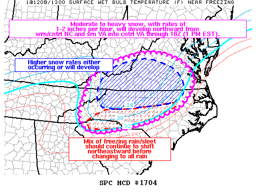
Mesoscale Discussion 1704 NWS Storm Prediction Center Norman OK 0718 AM CST Sun Dec 09 2018 Areas affected...Portions of far western SC...NC...far eastern TN...southern/central VA...and southern WV Concerning...Winter mixed precipitation Valid 091318Z - 091815Z SUMMARY...Moderate to heavy snow, with rates of 1-2 inches per hour, will develop northward from western/central NC and southern VA into portions of central VA through 18Z (1 PM EST). A mix of freezing rain/sleet ongoing across far western SC into parts of southern/central NC will shift northeastward this morning before eventually changing over to rain. DISCUSSION...A well-defined melting layer aloft was noted on dual-pol CC data from the KGSP and KRAH radars as of 13Z. A large area of moderate to heavy snow is ongoing across parts of western/central NC into southern VA per surface observations and radar imagery. As a southern-stream shortwave trough continues northeastward over the Southeast and into the Mid-Atlantic states, strong low/mid-level frontogenesis will likewise shift northward into more of central VA through 17-18Z. Heavy snow, with rates of 1-2 inches per hour, will also likely develop into this region as the low levels saturate and deep lift occurs through the dendritic growth zone. Farther south, a narrow zone of freezing rain/sleet is occurring from far western SC into parts of southern/central NC. Current expectations are for the low levels to continue to gradually warm, which will result in a north-northeastward transition of snow to sleet/freezing rain, to eventually just rain. Before this happens, several hours of freezing rain, with rates up to 0.10 inch per hour, may occur. However, temperatures near freezing will probably tend to limit ice accretion at the surface, except perhaps in higher terrain. ..Gleason.. 12/09/2018 ...Please see www.spc.noaa.gov for graphic product... ATTN...WFO...AKQ...MHX...LWX...RAH...RNK...RLX...CAE...GSP... MRX... LAT...LON 35288307 35808303 37008259 37498195 37828133 38078043 38267957 38257865 38007776 37687716 37267682 36917675 36347703 35847757 35247905 34968019 34698193 34798275 35288307
-
Sticking really good on cars and rooftops. Flakes are getting a little fatter and coming down steadily.
-
Snowing in Williamsburg and it's sticking, too.
-
Haha. Hope we can get more than that of course but have to consider how things tend to go with the tower observers. I'm in Williamsburg so not expecting much here today. Would be nice if we got enough for W&M to cancel classes tomorrow, but probably not.
-
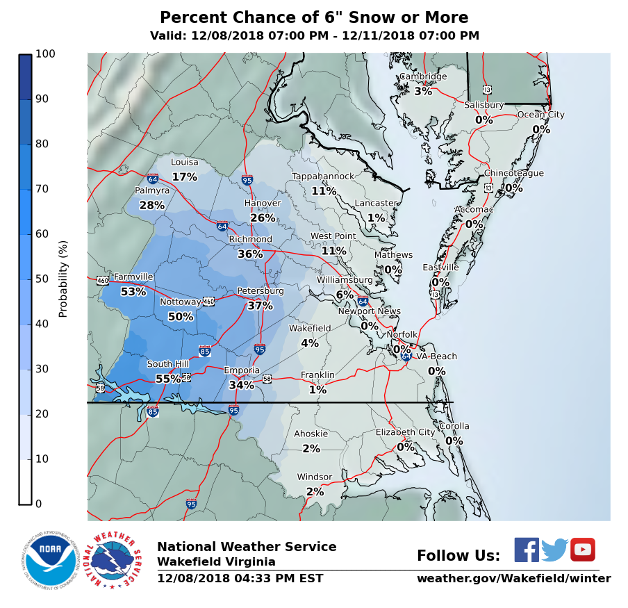
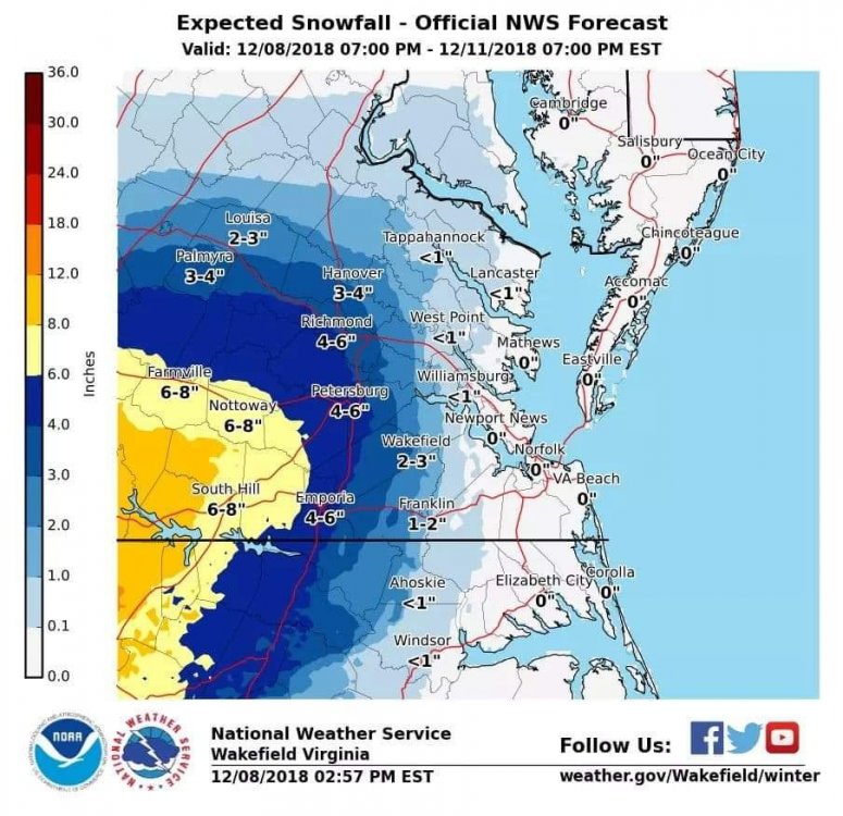
If I had to make a call for RIC officially, I'd go with 3.3". The daily snowfall record is 1.8" set in 1988.
-
If RIC reaches 6" tomorrow December 9th, it will be the 2nd earliest 6"+ snowstorm on record. The earliest is November 6, 1953, followed by December 11, 1958.
-
-

-
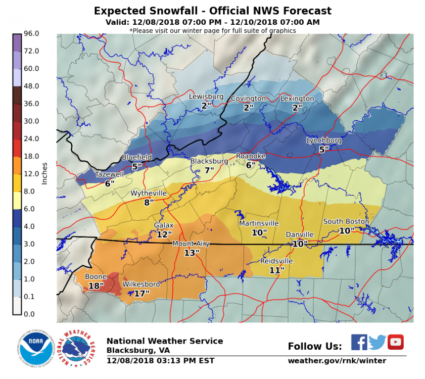
Those graphics are still from this morning.
-
-
18Z NAM just crushes the RIC area.
-
Watch just issued! URGENT - WINTER WEATHER MESSAGE National Weather Service Wakefield VA 250 PM EST Sat Dec 8 2018 VAZ048-061-062-068-069-509>516-090400- /O.NEW.KAKQ.WS.A.0004.181209T1200Z-181210T0900Z/ Fluvanna-Cumberland-Goochland-Amelia-Powhatan-Western Louisa- Eastern Louisa-Western Hanover-Eastern Hanover- Western Chesterfield- Eastern Chesterfield (Including Col. Heights)- Western Henrico (Including the City of Richmond)-Eastern Henrico- Including the cities of Bybee, Central Plains, Cunningham, Lake Monticello, Nahor, Palmyra, Troy, Angola, Guinea Mills, Hawk, Raines Tavern, Reeds, Stoddert, Goochland, Earls, Mannboro, Scotts Fork, Amelia Courthouse, Chula, Denaro, Jetersville, Fine Creek Mills, Flat Rock, Goodwins Store, Subletts, Worshams, Clayville, Genito, Louisa, Mineral, Ashland, Mechanicsville, Bon Air, Midlothian, Chesterfield, Chester, Colonial Heights, Richmond, and Sandston 250 PM EST Sat Dec 8 2018 ...WINTER STORM WATCH IN EFFECT FROM SUNDAY MORNING THROUGH LATE SUNDAY NIGHT... * WHAT...Wet snow, moderate to heavy at times will develop Sunday morning and continue through the day. The snow may mix with rain at times, especially closer to I-95, as temperatures rise above freezing. Total snow accumulations of 3 to 6 inches. Some light icing is possible Sunday night as temperatures drop below freezing. * WHERE...Portions of central Virginia including the Richmond Metro. * WHEN...From Sunday morning through late Sunday night. * ADDITIONAL DETAILS...Plan on slippery road conditions and potentially dangerous travel on Sunday into Sunday night. The wet nature of the snow will also allow it to stick to tree limbs which could cause some isolated outages. PRECAUTIONARY/PREPAREDNESS ACTIONS... A Winter Storm Watch means there is potential for significant snow, sleet or ice accumulations that may impact travel. Continue to monitor the latest forecasts. && $$ MRD http://www.weather.gov/akq
.png.0f8789ca16c7dd094d2aa83edfb9b1da.png)
-
Yeah, if anything, they should've issued a Winter Storm Watch and then downgrade it to a WWA later if necessary. I see that LWX has included Albemarle and Augusta, and Nelson Counties to a watch.
-
Definitely reason for concern. But, that won't be the dominate precip type.
-
They provided a late morning update, but of course, that was before all the midday runs were finished. Typically the afternoon package is sent between 3-5pm, so I wouldn't expect too much before then. Either way, I think we can make our own forecast with the information we have access to. AKQ is very conservative and typically catch up as we go along.
-
BTW, the RIC daily snowfall record for 12/9 is 1.8" set in 1988. Good chance it will be broken.
-
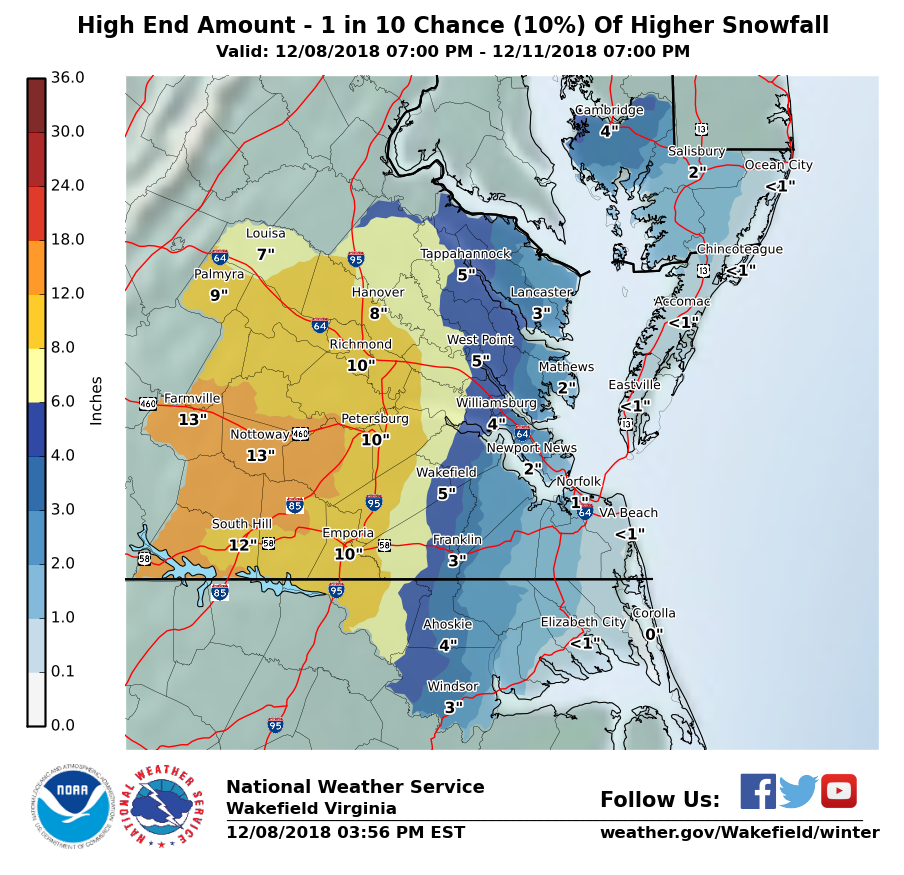
I like the trends on the models today. I think 3-5" is a solid bet for the RIC metro area which is not a bad way to start the winter. Been a frustrating week, never seems to be a slam dunk for this area.