
vespasian70
-
Posts
1,361 -
Joined
Content Type
Profiles
Blogs
Forums
American Weather
Media Demo
Store
Gallery
Posts posted by vespasian70
-
-
13 minutes ago, dilly84 said:
I'm blown away that no WSWs have been put up. The fact that some areas could see 3" an hour rates with tomorrow being a weekday, and the impact that would have is crazy to me that they'd all stick with an advisory
ILN have updated their snow fall maps many many times today, a hint that they may be a bit gun-shy in issuing anything more than an advisory at the moment. To that point, the setup is incredibly tricky.
-
18 minutes ago, dilly84 said:
Nam sticking with a foot lol
TT is a hot mess when it comes to mixed precip types and snow totals. If this system gives Newark a foot of snow I'll ride up to Apple Valley on my Unicorn and buy you dinner.

(I secretly hope its right!)
-
 2
2
-
-
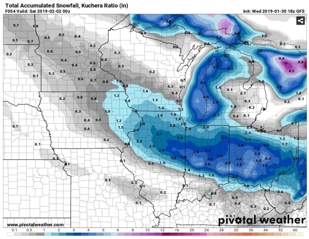
Loving the 00z HRRR for MBY. Nearly 6".
However, this kind of setup has huge bust potential for my neck of the woods. Fingers crossed!
-
6 hours ago, buckeye said:
the extended is rapidly turning into a dumpster fire.... starting with the late weekend event that now looks like it's heading north and leaving us with light rain. After that signs that the se ridge starts winning the battle. I just hope it goes ape sh*t crazy if it's going to ruin snow chances....go big or go away.
Outside of the 3 weeks in January this has been a dumpster fire of a winter for central OH. I was hoping it would end with a bang next week or so, but that ridge ain't moving.

#readyforspring
-
41 minutes ago, buckeye said:
More from "glass-half-full" buckeye,
The euro takes the mjo into 8 on Tuesday and now the gfs has it moving into 8 by end of week, (although looping it back out and back in again). Point is the gfs is correcting to a quicker move into 8 and euro is moving faster to it as well. All of that in combination with some hints that the endless cutter pattern the models were all showing over the last few days, is looking less "cutterish", has one of my eyebrows raised. (just one though).
Best thing I've read on here in a while. Keep hope alive.
-
 1
1
-
-
9 minutes ago, buckeye said:
Was just outside, pretty close to 6" here. Biggest one of the season. Curious to see what Columbus airport comes in at.
We were at 6" until that last heavy band pushed through around 7am, just when I was on the road. Dumped an inch in about 45 minutes.
-
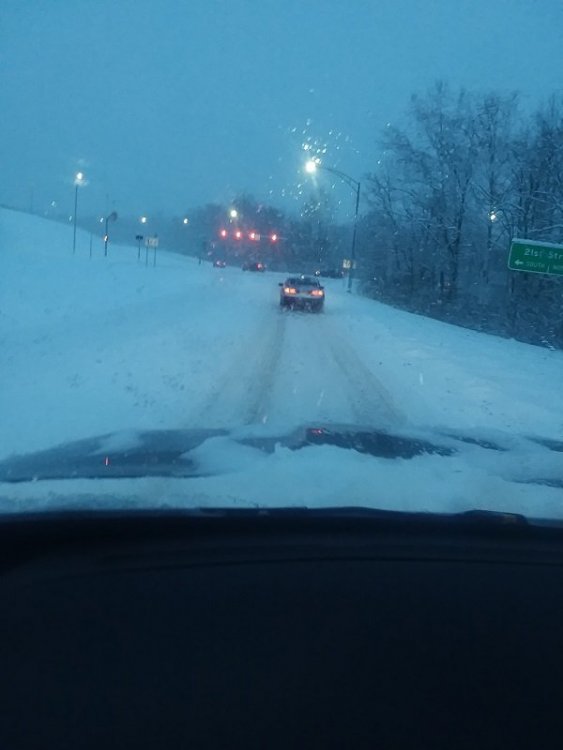
Over performer indeed! Ended up with 7" here.
Here's a bit of my morning commute.
-
1
-
-
3 hours ago, Chicago WX said:
Just received word that we’re a no go tomorrow too. Friday is gonna suck, but at least I won’t get frostbite in 5 minutes.

Day 2.
-
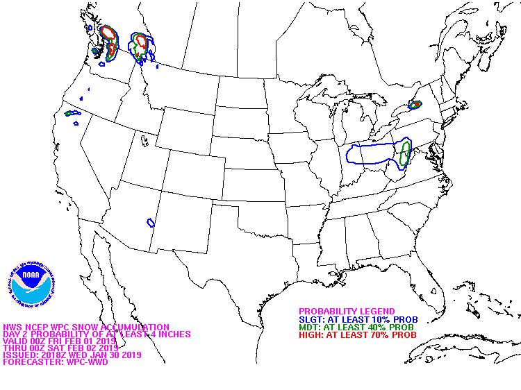
WPC showing a buckeye I70 special.
-
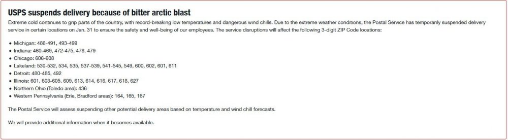
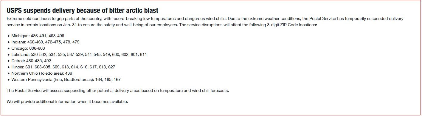
No mail today in many locations because of the cold.
-
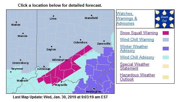
Good enough for an advisory I think.
-
1 minute ago, HighTechEE said:
Yep, it was one of the new winter items they announce recently. I think the big wrecks on I-75 from squalls last winter got them thinking about it.
Ah, that explains it. I wonder if these are hoisted based exclusively on radar? I'm pretty much out of range for ILN, snowing pretty good here but nothing on radar.
-
Don't recall seeing a snow squall warning from ILN before.
-
Woke up to a nice inch or so from the arctic front. At least it isn't bare ground.
-
35 minutes ago, Buckeye1994 said:
Very heavy snow squall just moved through southwestern Montgomery County ahead of the arctic front, dropped a quick 0.5, wind blowing it all around.
HRRR is picking up on the squall line. Curious to see how much it will be here.
-
So, you guys tired of tracking yet?
-
6 minutes ago, buckeye said:
Still holding out hope for a decent squall when the Arctic front moves thru tonight. Probably something the models aren't going to pick up on.
And then a minor clipper before the warm-up. *sigh*
-
26 minutes ago, dilly84 said:
Weird that radar shows nothing over me and its snowing hard out
Same here. Went to run a few errands and came out of Kroger to a hard snow squall, nothing on radar.
ILN and CLE are too far away to accurately pick up little events like this for Newark. I think we're both in a radar no man's land. Before my time there was a NWS radar in CMH, 90's budget cuts got rid of it.
-
2 minutes ago, buckeye said:
Don't ever recall a winter weather advisory where no precip was expected. Why wouldn't a wind chill warning cover things?
Heck, ILN might as well leave it up until Friday, perhaps they can roll the late week clipper into it. Lol
-
3 hours ago, buckeye said:
euro now has our coldest temps coming in only at around -3 or 4. zzzzzzzzzzzz what an absolute overhyped joke this is turning out to be, this may not even end up as cold as the period we had a week or so ago.
Good! I HATE frigid cold. Give me highs in the 20's and lows in the teens with some snow. I could care less about record low temps.
-
1
-
-
1 hour ago, Stebo said:
That is for lake effect, though I do think you should have been in one originally especially if you combine the synoptic with the lake effect snow.
Watching this from afar it looks like you've been under some good radar returns. Curious to see what you end up with.
-
31 minutes ago, OHweather said:
What am I missing? Isn’t most of central/southern Ohio near normal snowfall wise (some a little above, some a little below) with most of that falling in the last two weeks? The pattern also isn’t exactly warm coming up and it’s not even February 1 yet. It’s like reading a funeral in here because a surface low over toledo managed to bring sprinkles (it looks like the vast majority of your precip fell as snow with temps at or below feeezing north of Cincinnati and that maybe it briefly sprinkled). This wasn’t going to be more than an inch or so of snow anyways.
I think more than anything else it was last weekend that drained a lot us. Sure, the backend snow of 4"-5" was neat, but watching it rain all day prior to that showed us the missed potential. And last night ILN had CMH and KVTA for 1"-2", ended up a non event - a sloppy coating with marginal temps.
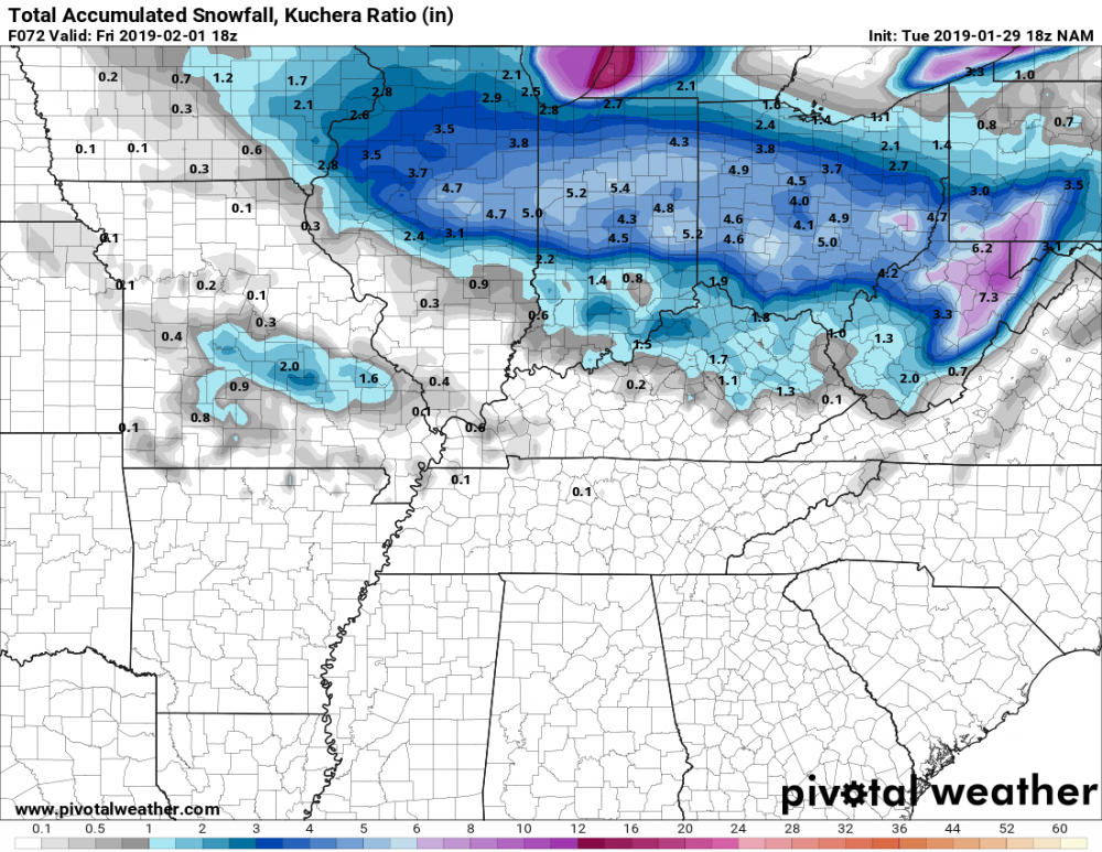
Next up, a decent clipper tracking far to our north. The 06z NAM was trying to develop a low along the Arctic front ... we'll see, lately our luck isn't the greatest.
-
2 hours ago, buckeye said:
Yea, speaking of mon/Tues,
euro has virtually little to no precip for us with the clipper passing north and the front speeding by. The cold shot is also somewhat muted and shortened.
This winter now has that imminent feeling of failure from here on out no matter what fantasies the models might conjure up in the mid to long range.
It's to a point where I'll believe it when I see it.
Here's hoping for a couple of dusty inches tonight, it may be our best shot before the Arctic front blows through.
-
A little skip of snow coming through this morning, a nice coating so far. Looks like we'll get a better shot of snow tonight, perhaps more than the Mon/Tue system.


Let's Talk Winter!!
in Lakes/Ohio Valley
Posted
Not a single flake here yet. Didn't know there was so much dry air to overcome.