

burgertime
-
Posts
11,171 -
Joined
-
Last visited
Content Type
Profiles
Blogs
Forums
American Weather
Media Demo
Store
Gallery
Posts posted by burgertime
-
-
If you want to feel better it can always be worse. The circled part is where I'm at and that little bit of snow is from the last couple of hours in the run. Outside of a little dusting the other night we've been in a total snow hole here the last few years, it's exciting just when a fantasy storm pops up that you know will never happen.

-
 1
1
-
 1
1
-
-
00z Euro OP run looked about where you want it 5-7 days out. As HKYWX pointed out the models are gonna be flip flopping dependent on those shortwaves that kick out from the west coast. The cold air is in place and that is the hardest step to get. Most of the time with this sort of cold air SOMETHING happens, the question is how big of a something. Wisdom says the OP models will probably pick up our storm again around the weekend as it resolves the s/w issue. Until then we read tea leaves.
-
6
-
1
-
-
55 minutes ago, HKY_WX said:
First 2 wks of march are often some of our best chances. On next week, the euro and gfs are notoriously bad at resolving shortwaves in the southwest. Until they agree on when it kicks out, there will continue to be wild Swings.
Bingo!
-
1
-
-
The best thing about this setup is real honest to goodness cold air to tap into. That's always the biggest issue for folks in the southeast, where is the cold air source? Always a good sign when the there's a chance the PV could give you snow showers just on the front of it.
-
6
-
-
16 hours ago, The Alchemist said:
I hope I’m not speaking out of turn as I don’t know the personal ins and outs of most of the posters on this board. I’m more of a lurker than anything else. But I wonder what the chances are of getting Burgertime to do a play-by-play of the European Friday night or Saturday night… It’d be fun for old times sake and really bring some good mojo to the board.
.16 hours ago, Bevo said:Ask him @burgertime
I'll see if I can join in on the fun. Only issue is, A I'm a bit rusty on the pbp and B I'm six hours ahead of you guys so the 00z run of the GFS comes out around 4:30 in the morning for me. The setup is certainly exciting, just wish we had the same in my neck of the woods!
-
3
-
-
21 minutes ago, burgertime said:
Correct me if I'm wrong but it looks like on some of the short-range modes the storms in the gulf is helping rob some moisture upstream. Keep an eye on that at is can does have an impact. I'm a little less worried about ZR with this one for NC as much as the issue now with radars showing this kind of patch flow on the short range models. Good luck and I hope it overperforms!
EDITED - I've been corrected. Please ignore. -
7 minutes ago, purduewx80 said:
That has little to nothing to do with it. The jet dynamics are becoming more unfavorable with time, resulting in weakening frontogenesis near and above 700mb, which had been tapping into the dendritic growth zone earlier this morning. The bulk of our moisture with this higher up forcing came from the Pacific. Low level winds out of the E or SE are also bringing in drier air out of the weakening surface high.
This was probably my fault as it's the end of the day here in the EU after a long week and I've been out of the game for awhile with winter storms in the SE. Thanks for the ACCURATE information!
-
1
-
-
2 minutes ago, msuwx said:
From my experience, Gulf convection that is 'positively tilted' like that can actually enhance the moisture transport northeastward. What you don't want is the convection to race out ahead of the system and it take on more of a neutral or negative tilt orientation. Don't know if that makes sense or not. I'm tired.
Ah ok, yea I must of had it mixed it up. I could have sworn it was robbing when it was positively titled but now that you say that it's all coming back to me. Damn this dyslexia!
-
 1
1
-
-
14 minutes ago, Snow dog said:
Yes-the northern half of the precip shield looks much less impressive than the bottom half..
Yea you can really see those storms line up vertically which IRRC (I'm a bit rusty these days) is what does the robbing. If you see the storms in a more horizontal alignment that enhances. So keep an eye on the live radar for that.*EDITED- Ignore this as I had it mixed up. Thus why you should always listen to the professionals!
-
 1
1
-
-
Correct me if I'm wrong but it looks like on some of the short-range modes the storms in the gulf is helping rob some moisture upstream. Keep an eye on that at is can does have an impact. I'm a little less worried about ZR with this one for NC as much as the issue now with radars showing this kind of patch flow on the short range models. Good luck and I hope it overperforms!
-
4
-
-
9 minutes ago, buckeyefan1 said:
Isn’t it always like that? It’s how we roll in the south

So true

-
2
-
1
-
-
I'm rooting for you guys. I'm a little worried about the lack of really cold air... But it's a good setup especially for WNC and along I-85. Like usual it's gonna be feast or famine probably. if you're in CLT I fear it'll be nailbiter as it looks now.
-
6
-
 1
1
-
2
-
 1
1
-
-
15 hours ago, StormyClearweather said:
That's what makes you the best at it. We had someone similar in the SE forum when I lived down there (h/t @burgertime) before he moved off to Europe. His go-to was "BOOM!" I'll gladly take either a "BOOM!" or a "FOLKS."
")
Really hoping you guys and the SE get it soon as well. Fun little fact I stole the "BOOM" from the "boom goes the dynamite" guy.
-
4
-
-
-
18z is extremly close to a bomb on this run for NC
-
1
-
-
18z ends up with a few lows coming through NC and floods the zone with warm air. Not the best solution but at 5h it looks close to me.
-
18z looks better orientated at 5h to me it's trying to get to a big solution.
-
2
-
-
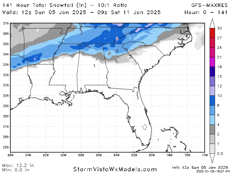
Here is the snow map out to 141
-
3
-
-
NC folks are praying for this solution
-
5
-
2
-
-
12z is def further south and weaker than the 6z run.
-
Funny thing always happens. When the SE sees a winter threat I usually do as well on this side of the globe.
We've also suffered a snow drought so I feel your pain (though we got snow last night). At this point I think all we can hope for is a good setup. It looks to me like a descent setup. Lots of energy flying around a cold air source and moisture on tap.
Curious to see how the 12z models look!
-
11
-
-
Checking in on the threads and it's good to see hardcore weenie action is still alive and well. Hope everyone impacted by this storm stays safe!
-
3
-
-
Hoping everyone stays stays safe in the SE. Just saw the Euro and wow, hopefully it weakens in the next 24-48 hours.
-
6
-
1
-
1
-
-
First, good luck to everyone this winter. I’ve been starting to track winter weather here in the Netherlands.
Decided to check in on what was going on in the SE with the pattern change. Next week and beyond looks interesting for sure. The 12z Euro map was a bit crazy. If this ULL can drop a little further south some folks outside of the mountains in NC/SC could get in on the action. Something to keep an eye on.
-
12
-
3
-
Banter Thread
in Southeastern States
Posted
Looks like you got yourself a new lawnmower for the farm!