
AlaskaETC
-
Posts
2,521 -
Joined
-
Last visited
Content Type
Profiles
Blogs
Forums
American Weather
Media Demo
Store
Gallery
Posts posted by AlaskaETC
-
-
-
1 hour ago, Chinook said:
might as well post this. NWS point forecasts for RMNP have 4"-8" at high elevations

Nice little early snowstorm for my backyard in Central WY.

-
 1
1
-
-
1 minute ago, Jebman said:
Which ski resort in Colorado or Wyoming typically gets the most snow in the March blockbuster blizzards?
One day, I am gonna position myself in one of those ski resorts and get my fill of snow WITHOUT the responsibilities I faced on the ranch down here in south central Texas during the Frozentine Day After Tomorrow Event last month. I'll just jebwalk myself to death in a mammoth 6 foot blizzard with headphones blasting, all without a care in the snowy world!
Anywhere in the Front Range would get you plenty of snow every year.

-
1
-
-
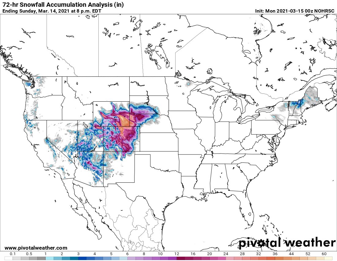
26.3" in Casper, 21.2" today alone. I was a little lazy in measuring, but I thought we got way less than that! The radar returns weren't looking great, but I guess it was radar shadowing or something.
-
2 minutes ago, Amped said:
Models were 5-6" too high with the snow yesterday and about 3-5" too low today.
Looks like they overestimated the SE flow regime and underestimated the N flow regime on the south side of the CCB. Heavy snow started right as the 700mb winds started cranking out of the north. The storm did not really track further north than predicted. Palmer divide was always going to be the southern cutoff.
The NWS snow obs were pretty much in line with the Euro/NAM about two days ago.
-
30 minutes ago, raindancewx said:
Looks like the HRRR really handled this storm well, along with the NAM and Euro.
-
5 minutes ago, Wentzadelphia said:
Where is this? NAM showing decent hit here Tuesday

Custer County, decent elevation in that area
-
About 12" here in Casper. A little bit under the forecast I think. Seems like the moisture had a tougher time getting here than predicted.
-
-
Cheyenne with nearly 26" of snow. Jackpotville
-
1 minute ago, smokeybandit said:
Denver really cashed in today. The dry slot last night looked brutal.
-
2 minutes ago, Ji said:
this looks really unimpressive....what happened.
Similar to what happened in Denver I think.
-
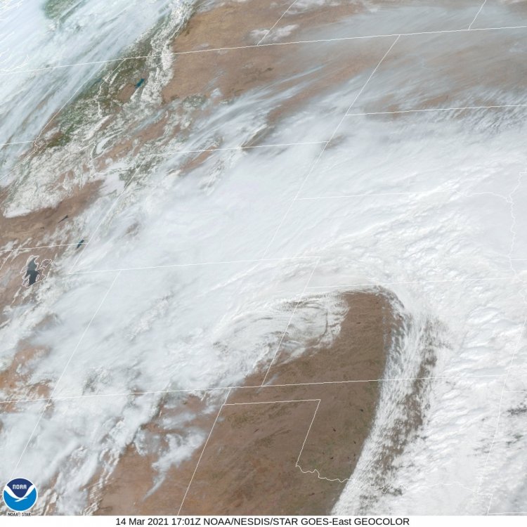
This is textbook stuff. Worth saving these images.
-
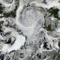
This storm sure is a beauty.
GOES-East - Sector view: Northern Rockies - GeoColor - NOAA / NESDIS / STAR
-
1
-
 1
1
-
-
This from NWS Cheyenne earlier, but this Forecast Discussion is worth reposting -
QuoteArea Forecast Discussion National Weather Service Cheyenne WY 458 PM MST Sat Mar 13 2021 .SHORT TERM...(Tonight - Monday Night) Issued at 335 PM MST Sat Mar 13 2021
...HISTORIC AND POTENTIALLY CRIPPLING BLIZZARD ON TRACK TO SEVERELY IMPACT SOUTHEAST WYOMING AND THE WESTERN NEBRASKA PANHANDLE OVER THE NEXT 24 TO 36 HOURS...
A broad area of moderate to heavy snow is quickly spreading across the region this afternoon as vigorous, deep cyclogenesis continues across the 4 Corners region. An impressive GOES-16 WV display with a beautiful baroclinic leaf to support the intense organization of the expansive extratropical cyclone. Snow was very slow to develop today, but recent surface & upper air analyses confirm that models remain on track with the storm position & intensity. We could have a brief period of dry slotting, but radar trends indicate that new precipitation is already beginning to develop upstream due to very intense upper-level difluence. We will definitely see a very brief decrease in snowfall rates this evening, but fully expect snowfall to pick up again during the late evening and overnight hours, with conditions rapidly worsening through early Sunday. Synoptic set up is there for this storm to stall over east central Colorado during the next day or two, w/ a persistent TROWAL & deep low-lvl upslope maintaining heavy snowfall rates through late Sunday. SFC pressure falls are evident over eastern Colorado at this hour, contributing to increased confidence in a favorable position of the surface low for high-end snowfall in the region. In addition, models are still hinting at the development of a strong barrier jet in the vicinity of the front range, making the synoptic setup extremely similar to historical snow storms including the legendary March 2003 storm in this region. High-resolution models and GFS/ECM ensembles continue to show impressive totals of 2-3 feet over the I-25 corridor. This is likely to be a record-shattering storm.
Winds have trended stronger with 700 millibar flow of 50 to 60 kts overspreading the entire area overnight tonight through mid day on Sunday. Deep unidirectional east-northeast flow suggests gusts for many areas in excess of 50 MPH, which prompted earlier upgrades to a Blizzard Warning for all of the eastern plains along and east of the Laramie Range. As strong winds coincide with the heaviest snow rates tonight and early Sunday, this is when conditions will be at their worst. Travel will be extremely dangerous, if not impossible and conditions will be life threatening w/ whiteout conditions for many areas. Power outages are also likely with power lines already stressed due to the icing this AM. Severe conditions will continue through Sunday afternoon with a gradual decrease in winds and snow rates heading into the evening and early Monday.
-
1 minute ago, Ji said:3 minutes ago, AlaskaETC said:The radar returns look a little dry across the board. I wonder if the convection further east is stealing some moisture.
Lol sounds like a dc ob smh
Cheyenne looks like Jackpotville right now
-
The radar returns look a little dry across the board. I wonder if the convection further east is stealing some moisture.
-
Bit of a dry spot developing on the radar between Casper and Douglas. A bit concerning but I assume it will fill in soon.
-
The 0z 3k NAM nukes the Cheyenne area from 12:00AM-7:00 AM. It is still kind to the Casper area, giving 20-25" verbatim.
-
The 0Z HRRR plasters the entire area from just south of Casper to Cheyenne. Wide swaths of 30" or more
-
Starting to accumulate here. Looking to get 8" or more overnight according to the HRRR.
-
1 minute ago, n1vek said:
Looking at recent guidance, seems like the slower/south camp is working out? Will be interesting to see how this materializes overnight? Someone check me here if I am wrong.
I've noticed a tick up north in some of the HRRR and other mesoscale runs but maybe that's just me.
-
Starting to pick up here in Casper. A slight wind, 32 degrees.
-
4 minutes ago, STILL N OF PIKE said:
HREF 12z MAX amounts (NOT mean) Thru 12z Sunday (If i am reading that correctly)
From the looks of it, the mean is also very generous for most areas.


Mountain West Discussion
in Central/Western States
Posted
Expected to get another 8-12" today, with 16" a possibility it seems. I thought the NAM was being the NAM but I guess it was pretty spot on.