

METALSTORM
-
Posts
78 -
Joined
-
Last visited
Content Type
Profiles
Blogs
Forums
American Weather
Media Demo
Store
Gallery
Posts posted by METALSTORM
-
-
Seems like Sunday could be an opportunity for dryline chasers. A good preseason game to get the equipment ready.
-
100%. Unless it's snow in the Carolina's then SE is a ghost town. That's ok. It's what they like and I don't think they will even notice if MS and AL and even GA are moved.
-
Near St Louis in Jefferson County MO. My kids school is having late pickup kids be in the art room this afternoon which is in the basement area. Bright sunshine over the area with rapidly warming temps
-
Is there an analog to compare this to?
-
 1
1
-
-
4 hours ago, Cheeznado said:
Moisture is the big issue, models still differ on how much will make it how far north. Dynamics off the charts with ludicrously high SRH values, so a raging squall line is very likely at the very least. Another bugaboo for chasers are the insane storm motions, 60-70 mph. If I were local it would be worth a shot but there will be much better situations down the road.
More of a lucky intercept setup than trying to follow any cells.
-
Surprised this hasn't been brought up yet but it looks like a decent episode of pre season severe for the plains.
-
-
Got a WSW from LSX for the I-44 corridor and south. SGF and PAH in on the action too.
-
4
-
-
2 hours ago, CheeselandSkies said:
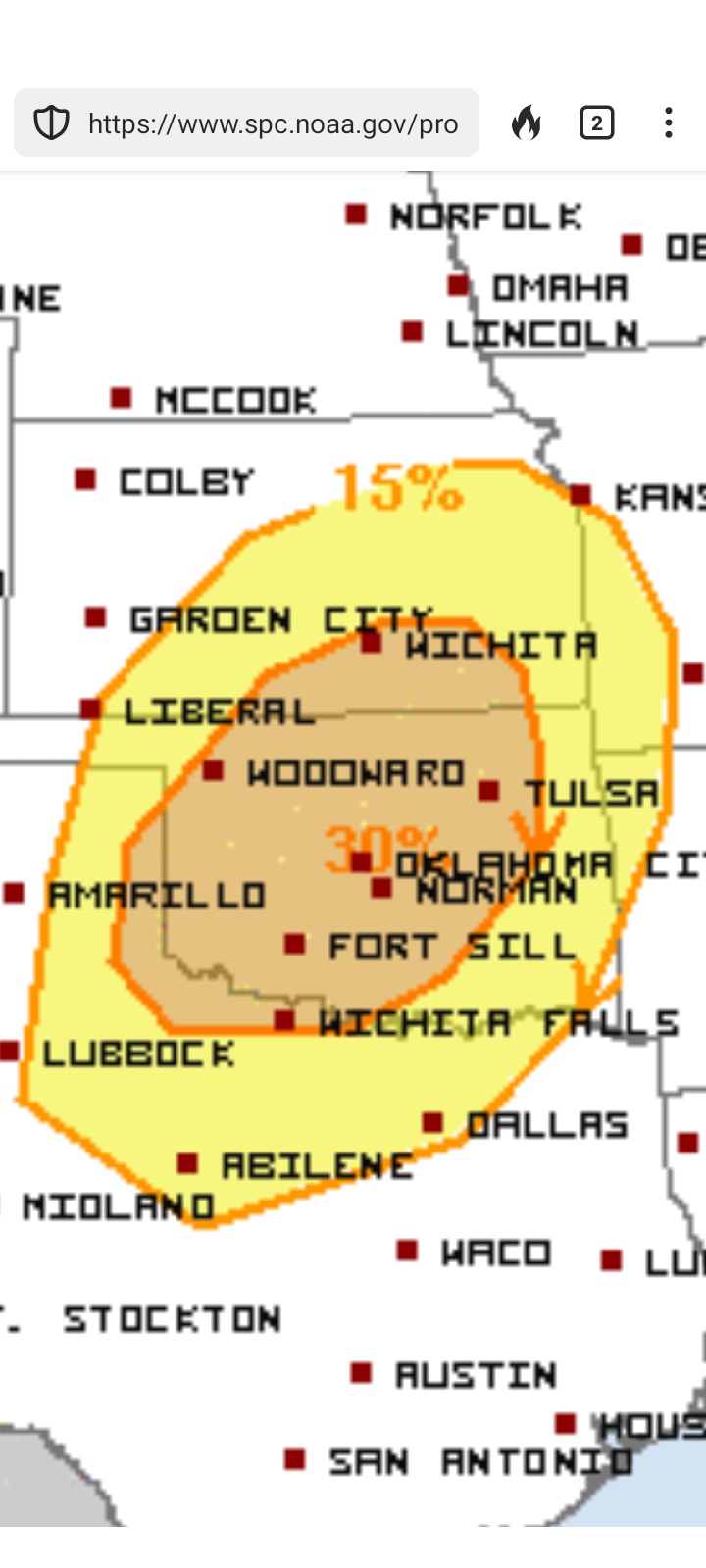
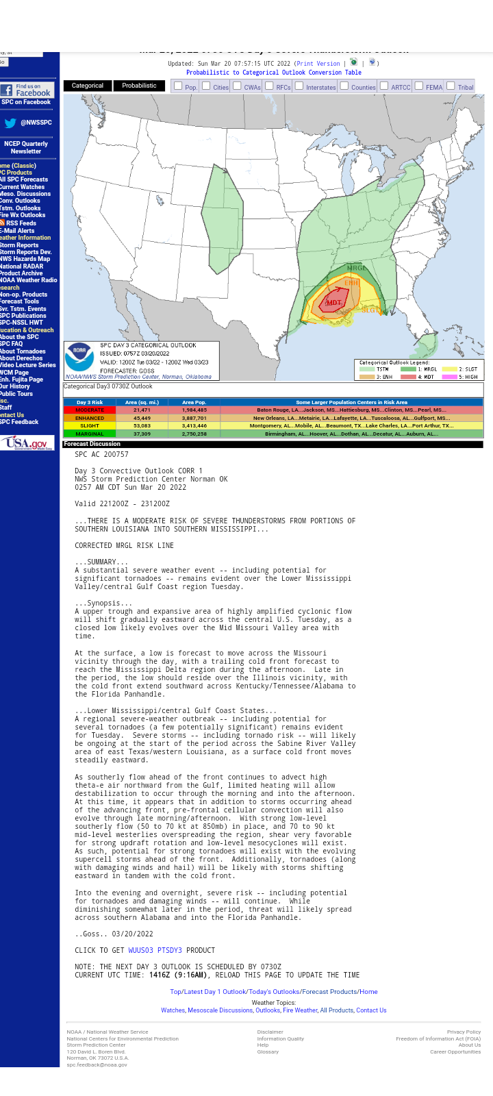
SPC has maintained a pretty large 15% zone valid for Monday 1/2 for the last two outlooks. They haven't seen enough model consistency/agreement for anything further.
Reminder that this thread is for those of us who want to discuss convective weather/ threats. There are other threads to complain about lack of sufficiently wintry conditions/lament snow opportunities lost.
Sent from my Pixel 4a using Tapatalk
Thank you. I'm far more interested in severe than winter weather and the Lakes/OV and Central are the last bastions of severe weather discussion on Am WX. And Saturdays model runs should start painting a clearer picture for Monday.
-
1
-
-
Just wanted to declare the SE Forum dead as far as severe weather is concerned. Southern VA and the Carolinas should be their own winter obsession forum. I'm happy there are posters in Central that watch and post on these events.
-
5
-
 1
1
-
-
Seen more than 1 forecast mentioning the possibility extending to the mid MS Valley. LSX mentioned the possibility in their morning forecast discussion. Quite a ways away. Interesting to see if/how this shifts in the coming days.
-
The SE forum is mostly comprised of people in the Carolinas. They'll closely follow a 384hr model predicting a trace of snow in the Piedmont but they have 0 interest in severe. Kind of the same with TN Valley. Just how they are.
-
4
-
-
Looking at the LSX afternoon disco, they seem to think there could be some potential into SE MO and Southern IL. Very interested to see how the outlooks progress tomorrow and into Tuesday. A few shades of Dec 10 of last year. Hopefully nothing like the destructive results of that outbreak.
-
I checked the Southeast and TN Valley threads and found a cursory mention in TN Valley. I imagine this thread will be picking up the pace by Monday evening. I hope, anyway.
-
2
-
-
Wait until Sunday. It'll be hopping.
-
Messy line with potential spinups. Looks like a few storms trying to fire ahead of it but nothing impressive yet as far as discreet cells go.
-
DFW, Waco, and even down to near Austin look to be in play.
-
I started a thread in the Southeastern sub. Whether it gets any traction over there is another story. I wonder if MS and AL should be adopted by the Central forum lol.
-
5
-
-
-
Amazing info here. Now back to the regularly scheduled forecast of a half inch of snow possibly in the Piedmont on the 384hr NAM
-
1
-
-
19 minutes ago, sbnwx85 said:
Posting for posterity's sake seeing McDonough County highlighted in pink around a sea of blue. It's just fun.
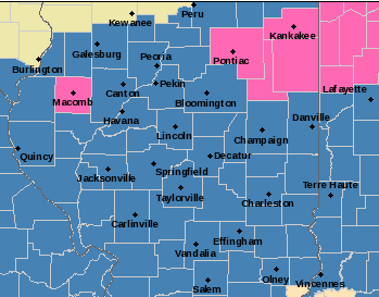
Weird
-
LSX calling for widespread 6 in plus across most of their forecast area and likely starting out as an icy mix of freezing rain/sleet. Potential for double digit amounts if some models are to be believed especially north of I-44. Interesting that this is going to play out on the anniversary of the 1982 surprise "blizzard" that paralyzed St Louis and surrounding areas.
-
2
-
-
Where should I post for the LSX area? I feel like the mid MS Valley is a no man's land between this region and Central/Western sub.
-
1
-
-
Does anyone know if there will be a NOAA service assessment?
-
1
-

Severe Weather 4-15 and 4-16-24
in Central/Western States
Posted
100% chance of chaser traffic jams.