

dryslot
-
Posts
58,691 -
Joined
-
Last visited
Content Type
Profiles
Blogs
Forums
American Weather
Media Demo
Store
Gallery
Posts posted by dryslot
-
-
It is definitely east by a bit
-
SE mass and the cape has never been in question, Its the western zones that are in play here
-
Hard to follow. One person says it's going east, the next says it's going north. I think it's time for bed
Your fine, Relax
-
lol...the model is so horrible. Nice hit here, but does it even matter?
Looks like we are down to one and one only unless the RGEM comes back towards the Euro at 0z
-
Lol, the NAM shifted 100 miles in 1 run on a 12 hour forecast (vs 6 hours at 00z)
lol, It was out to lunch
-
How does this eastward shift affect us peeps in SW and central ME?
It more the trek north then east, If it keeps going to far east, It takes the heavier bands with it to the east
-
While that may be the case, 4 runs ago the Euro was giving all of NJ 3-4' of snow....and every run since it's chased NE. IMO that will continue with the 0z tonight. So in this case - the "delayed capture" really isn't an east tick. It's the low getting further north before it's captured which ultimately leads to a little displacement NE each run.
I may be totally wrong on this final call for a Euro shift at 0z, but if it comes to pass that'll be the third time it's tried to stall a low too far SW since March. A developing bias to this new incarnation? I'll throw down a round at Stowe that it'll adjust in some capacity N or E from the 12z.
Matters not for most, and if it wraps up enough it'll still toss back plenty of precip to the west and south.
And the Euro has bumped qpf numbers up here the last 3 runs as well to reflect it getting further north, We saw this same thing happen up here with Nemo
-
22z HRRR comes west a bit. Analyzing these hourly models blows.
I hate them, Especially that one
-
We will let mother nature know of your demands
-
You, ftw.

Just going to sit back Mike and enjoy whatever falls, Good luck to you as well
-
I love the east vs. west....north vs south...NE vs. SW...etc battles that go on in here during these storms while jockeying for jackpots and hardest impacts.
Today is toss the model day, If it does not show your max BY total toss it, I look at all of then and i end up with the same 1.25-1.50"+.......................

-
Nice W. MA has moaned their way to the 24-36 range and meanwhile I get subsidence and only 18 inches
Wow, Only?
-
Plenty here hoping its wrong.............lol
-
Thanks Brian
-
RGEM is a tad slower also. Great run for so many of us. Today was the day I finally felt good about getting close to 2 feet. I knew it was 18+ most likely but today some of the deets got ironed out. We'll see if there are surprises. I don't care if I get 14 inches as long as BOS gets 2 feet....lol.
Long duration right into 18z wednesday up here on some of the models
-
GYX map update coming as they took it down

-
18z NAM QPF... two large metro areas just destroyed. A Tolland County nightmare. The NYC battle is amazing... EURO and NAM going big, a lot of other models going quite low.
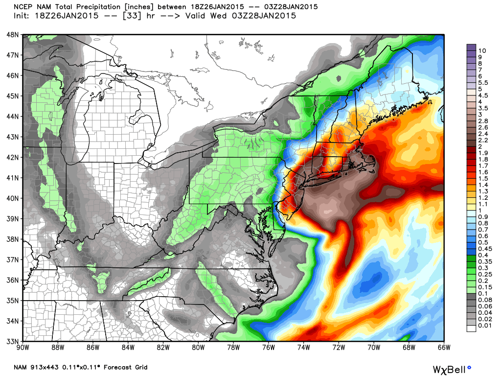
Thanks, You left some qpf on the table for your brethren to the east here, Take it to hr 54 please, Thanks
-
Euro gets it way north. It should be more SW-NE at our lat when arriving and then N-S before pivoting out.
Dryslot...close to 1.50" I'd say for you.
Thanks Brian
-
GYX map update incoming i think
-
My plow friends have been calling. I was really ready to downgrade here in the Lakes Region of NH to a 8-12" type storm. Now the Euro is insistent in these heavy amounts up here too. I would guess the Euro will cave unless we start seeing a west trend at 18Z
Yeah, Everything to day has brought the heavier precip up this way as this one looks like its closing off slightly NE of where it was yesterday
-
1.50" line from LEB to IZG
1.00" line from PF to the Ct Lakes...lol
Hard number here Brian?
-
Euro not backing down for WNE and up here. Wow.
That just bumped things up a tad..............lol
-
No doub't its cold
-
Yeah it really cut down out west...BTV's southern Warnings and most of ALY's warnings would be in trouble, especially Litchfield's Blizzard Warning.
Well, I am enjoying these trends, My qpf keeps bumping up.............
Forecast/storm discussions and part II Manitoba Mauler
in New England
Posted
Yeah, That is a very good hit, Do you have qpf numbers brian?