mgerb
-
Posts
327 -
Joined
-
Last visited
About mgerb

- Birthday 04/17/1981
-
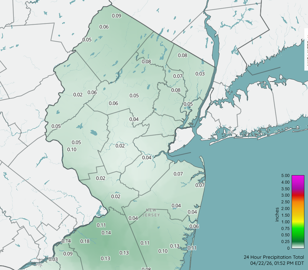
0.48" for the day here. A nice surprise, as was expecting a few tenths at best.
-
For NJ, I recommend this. And there's also CoCoRaHS, but most AM reports happened before all the rain had ended. https://www.njweather.org/maps/?refresh=1&map=precip_24hour

- 970 replies
-
- 4
-

-
- april showers bring may..
- rain
- (and 2 more)
-
I'd also say it depends on the time of year. Low 60 DPs in April is pretty muggy. Mid-summer, it's refreshing.
- 970 replies
-
- 3
-

-
-
- april showers bring may..
- rain
- (and 2 more)
-
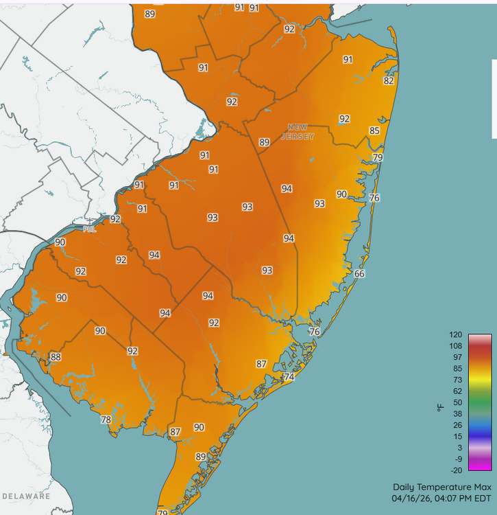
Mid-90s in interior southern NJ. Yeesh.
- 970 replies
-
- 2
-
-
- april showers bring may..
- rain
- (and 2 more)
-
@RU848789 Not yet; haven't had the chance. I'll try to chime in this weekend!
-
Something to consider from the MA thread, which makes sense. In other words, somewhat small changes upstream can really make a difference (in either way, of course).
-
Yup, saw that's how what you do. That's not how it's done in CoCoRaHS and COOP, so I don't really agree with this article. Rather, the maximum accumulation over the prior day of all snow/sleet is what is reported each day. That said, passing this along to some "snow experts" to see if they've ever heard of this practice.
-
I also don't clear the board except for ob time. If I cleared the board at transition, would obviously have more, but that's not really kosher (at least for CoCoRaHS).
-
I had 7.6" around the time of transition, and every time I went back out to measure each hour, it remained at 7.6". So there was enough compaction to counter any sleet accum. Haven't been out since 4 PM though, so will check again at 7:00. Hopefully have resumed a bit of accumulation since then, rather than only making the existing back denser (but not deeper).
-
Snow/sleet mix now. But still plenty of flakes.
-
When I checked at 12, I had 0.64" (based on weight). Definitely a tough event to get an accurate SWE.
-
Kickass. Keep it coming. Can't believe it's still 11 deg (edit: now 12 deg).
-
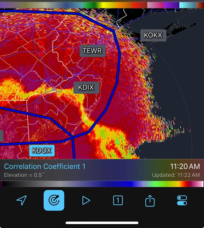
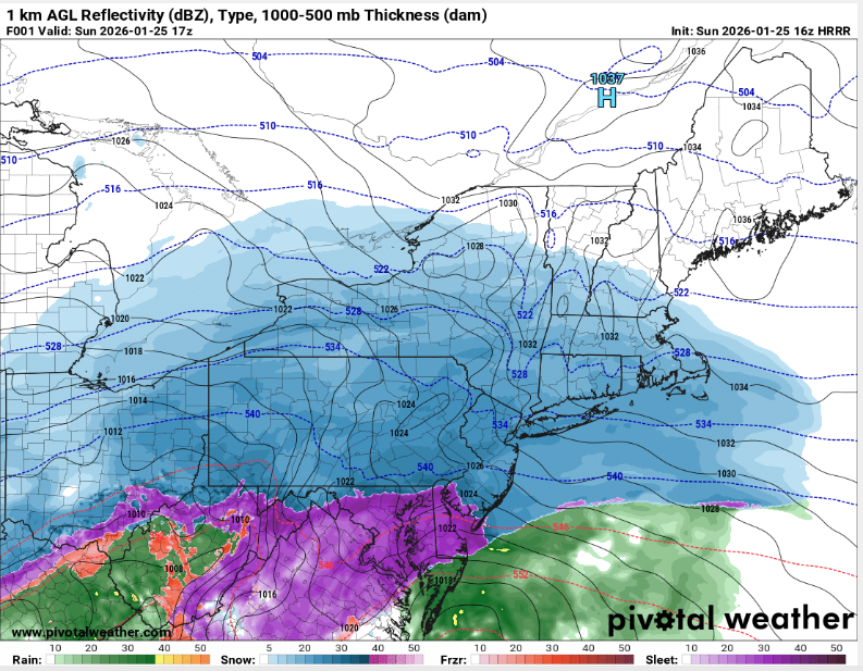
What's your mix? Some snow, some sleet? Oddly, there's little signal on KDIX base reflectivity (or the other tilts), but KDOX shows it well.
-
FWIW, HRRR hr 1 (12 PM) is too far south with the sleet line, as it appears to be approaching southern Mercer/Middlesex in NJ (based on CC and mPING). Around 7" so far here, so might be able to pull off low-end double digits with sleet included. But also suspect there will be some compaction with the sleet on top.
-
Snow/sleet line is further north than this indicates. KDOX shows it well.