
Huffwx
-
Posts
2,873 -
Joined
-
Last visited
Content Type
Profiles
Blogs
Forums
American Weather
Media Demo
Store
Gallery
Posts posted by Huffwx
-
-
9 minutes ago, DarkSharkWX said:
this really isnt an anafrontal event anymore, the reason why we're getting sm snow on recent runs is bc of a secondary coastal snow forming and undergoing surface cyclonegenesis which throws moisture nw back into the cold sector, this isnt cold front trying to catch up to precip
This. That 500 low goes negative a low forms over South Carolina
-
 2
2
-
-
19 minutes ago, buckeyefan1 said:
FWIW the nam has now closed off the energy coming down into the plains on this run, taking a step towards the gfs.

Most won't remember but when the Jan 2000 storm passed over KC upper air vort (like this one will be close) they had a snow event that caused the icy roads that lead to the car wreck that ending up killing Derrick Thomas, albeit 2 weeks later. Morbid, i get it but I always connect the two.
-
2
-
-
14 hours ago, CAPE said:
Looks great for getting outdoor projects done with no bugs and nice temps. We are rarely wetter than normal in a Nina. Looking forward to it.

Not that the reverse psychology works, but it seems the Euro and UK seasonal outlooks were promising in the 2 of past 3 winters. I guess last winter had some great features (-nao) with no blocking, so who knows. That be a super warm winter though.. like you said.
-
NYC Central Park has a 40 inch winter and someone complains about it-- Wow.
-
10 minutes ago, BristowWx said:
That's the way the GFS seems to be playing it. Of course its in the 40s/50s with rain delivering the 7-10 split. but yes its coming straight at us.
That flat ridge in the GOM isn't helping anyone.
-
3 minutes ago, chris21 said:
Pretty stout west based neg nao doing it’s thing there.
Pretty warm out in front-- despite the NAO and lower heights near 50/50. IT's a timing issue where cold air is coming at the same time as the storm. Could end up 300 miles north or south depending on timing.
-
1
-
-
10 minutes ago, DCTeacherman said:
Didn't we have legit arctic air with that one? I think I remember smoking cirrus up here in the DC area and it being like 20 degrees for the high. This one with a very marginal airmass doesn't seem it could produce such a wide swath of heavy snow,
I live just outside Lynchburg. Was 40 the day before and the day after. Snowed all day with temps in the mid 20's. We did have perfect timing with a HP sliding through but the air was more dry than cold. Take out the precip and we would have hit 40 that Sunday as well.
-
31 minutes ago, psuhoffman said:
We had a nice AO block in Dec though but it was centered northwest of a true NAO block. I respect Tombo and others who are saying it’s just higher heights but I respectfully disagree with that take. First of all it’s impossible to see the ridge in the height lines past 12 days or so due to timing and location differences between members. One might have the block centered over Greenland. Another Baffin. Another Hudson Bay. The ridge meanders around. Those differences smooth it out. Then you add in the outlier members and seeing a ridge signature at that range is not happening. But at the same time those kinds of + anomalies would be unlikely without a ridge somewhere. If it was weak + heights maybe. But to get those kinds of positives at those ranges given the smoothing and outliers would be almost impossible without a ridge somewhere on most members. Also we wouldn’t get lower heights across the CONUS with that pac if there wasnt true blocking. Add in the fact that the control has a true block and when I look at most operationals and individual members they do have blocking the evidence suggests that’s not it. I respect their hypothesis but I don’t see evidence of that.
I think the simplest answer is the best. The pac is less then ideal. We begin the period with all of N AM torched. Despite a really good h5 look it thinks we never recover in that regard. History says domestic cold should work in that look. But the eps weekly members obviously think it’s just not going to be cold enough to keep storms from cutting. I think it’s wrong. I’ve seen it run too warm at range. We’ll see
Ji showed a graph where the NAO wasn't negative. I said a few times heights were higher Azorors were high as well and that is how they measure ( or use to)
A lot of gray on on the calculations but agree base is warmer and PAC isn't helping.
In early 02, we had blocking and it got colder as heights lowered. Had a suppressed storm Richmond to RDU.. maybe 12 at RDU again.
-
55 minutes ago, Ji said:
i wonder if we are failing in our -NAO pattern because dont have a -NAO
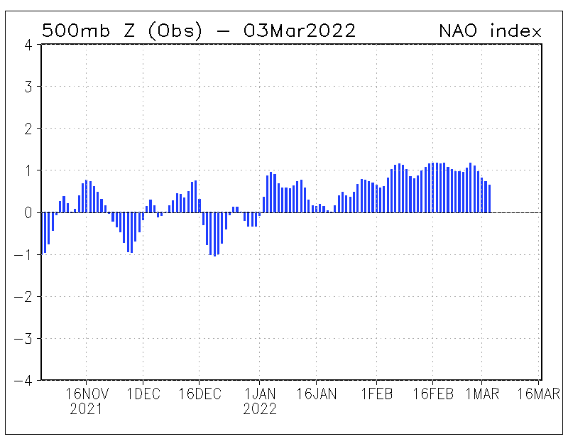
Heights were high near Azores as well..
-
26 minutes ago, psuhoffman said:
That’s the H5 from the end of January 2000.
We have high heights over Greenland but the block extends to near the Azores.
-
Had about .3 at my place in Forest. My office is right behind WSET TV- the official measuring station for Lynchburg. They were shut out last year for the first time ever (We had .3 in Forest last year too) Not sure what fell here at my office counts as more than a trace.
-
1
-
-
BWI: 14
DCA:9
IAD:17
RIC:5Tiebreaker ( LYH): 12.5
-
Just now, Ji said:
that storm was nuts...so picturesqe...heaviest wet snow ive ever seen. think it all melted the next day lol
Yeah, only one day out of school with 15 inches where I was. If this vort passes to anyones south, they would get some crazy rates for a while.
-
4 minutes ago, Ji said:
we need @psuhoffman to tell us how this can happen and why it wont....does anyone have any information about the FEb 88 storm...it was 53 degrees before the storm and we got a foot of snow with temps in the 36-37 range
That was Feb 87. Temps hit upper 40s where i was but were at 37 when it started and hoovered around 32 all storm. Was a triple phaser actually.
-
1
-
-
About 1.25 just west of Lynchburg. Crappy ratio..7 to 1 maybe but roads are coveres. Sleet in Roanoke off and on. Hopefully we hold out a few hours.
-
24 minutes ago, Bob Chill said:
I know some people hate hearing posts like this but i'm tossing all ops except the euro if it doesn't waver at 0z tonight. Its been the most consistent and appears lasered in. Qpf distribution always moves around a little but the euro is being really stready with the progression.
I think it has moved around. It was very suppressed then surged north on the euro. She's having trouble from the foul line this yeat
")
-
On 11/15/2018 at 3:37 PM, LibertyBell said:
Oh thats what I originally thought so maybe he was thinking of that one too. I dont remember any November snowstorm in prior years.
I guess it's relative about suppressed storm tracks because in our area we've had a tendency for storms to be more amped up than what models were originally showing- it's been happening for a few years now.
I think all coastal lows have always been too far south per modeling. I 've been tracking model data since 1999.. always too suppressed.
-
1
-
-
8 hours ago, LibertyBell said:
I think you're talking about the Vet Day 1986 snowstorm? Winter 1986-87 was interesting, with 50-55 inches just south of NYC with NYC getting fringed a lot with about half that snowfall, In the new climate those storms would probably track more northward, we hardly ever see suppressed tracks anymore outside of the extreme winter of 2009-10 and even then the tracks eventually adjusted northward.
1957-58, 1986-87, 2004-05 would be a nice nino lineup except I think the first two of those were stronger than this one is likely to be. All of them had over 40 inches of snow here or close by (in the case of 1986-87 just to our south.)
Vets day storm was 1987.
I'm not sure what you mean by no longer suppressed. I'm a philly native who lives in SW VA. We had 2 storms shunted to our south last year were we got 2-4 and south areas into NC got 6-10 inches.
-
Jan 30 - Feb 10 would get 99% of the votes.
That's high considering the RIC and SW posters. Jan 87 was much better..
-
I don't recall when the watches for Feb. '87 were issued. The first I heard of an impending storm was late Sunday afternoon. We were playing basketball (outside, so that should tell you a major snowstorm commencing in less than 6 hours was a bit surprising) when someone mentioned it. The rates that night were intense.
I raked leaves that afternoon. I remember calling the weatherline that RICH HITCHENS worked Sunday am after a sleepover over and was shocked there was a WsWatch Sunday AM.. Saturday PM had a chance of rain or snow Sunday night.
Around the DC area it went from a 1-3" or 2-4" snow to about a foot or more and if I recall correctly we had the whole week off of school due to power lines down from the weight of the snow. It was definitely not expected to be such a big event at least here.
Gotcha. I guess the 00 storm to me was such a drastic shift from no storm out to see to BIG event in 6 hours. Now, Feb 22 87 was actually a triple phaser if I'm not misaken and it bottomed out 965 east of ACY?? So, I guess that was a big miss in that context but more lead time where I was in a lesser model era resonates with me.
-
i said feb 87.
There was still a winter storm watch Sunday AM< upgraded to a warning for 4-8 where I was in Northen Delaware with the afternoon package.
-
jan 2000 is probably in the hall of fame, but i can't put it in the top 5 winter storms here. i guess i could see why it might be a "favorite" for some, but we've had bigger and better events.
i was too young for 83, but from what i heard the rates were legendary. feb 87 had pretty absurd rates too (heavy, wet snow) and was a surprise event on the scale of jan 2000.
Jan 87 was not on par surprise with Jan 2000. We knew there'd be a nor' easter on Jan 22. We had Winter Storm Watches issued on Jan 21st in the morning package. They upgraded the areas NW of the big cites on the evening of the 21st and the 95 track was 1-2 inches, before changing to rain, but the Watch was up still. I was in Wilmington, Delaware and we were upgraded to a warning about 8pm Wednesday evening (Forecast at that time came from Sterling, not PHL) for 4 inches, then sleet and rain and then before the snow started Thursday am, 6-8 inches, possibly mixed with sleet.
Night and day to me surprise wise..
Wes Junker tells a good story how the NGM had the colder profiles and was higher res...
-
The answer is 96 and it's not that close. Other storms may of had bigger impacts, but in smaller regions. 96 had 18 + from VA/NC border NE to NYC. It was the largest coverage of the largest totals.
79..DC to Philly focused
83-83 Maybe second considering all things and the 18 spot in Richmond.
86-87 impressive back to back totals but that's not ONE event.
02-03, not much snow south of DC. sleet city.
Dec 09 was close but you lose Richmond and the Beach areas which had 6-12 or more in 96.
Feb 10 such a broad area of 6-12 ish in Southern VA, lesser amounts into PA and parts of NJ
-
Jan '96.
/ drops the mic and walks off stage
This.
People can say what was best for THEIR house, but largest coverage of over 20 inches is Jan 1996
12/10-11 Disco / Obs - Rain/Snow/Wind Event
in Mid Atlantic
Posted
Hey now, Howard. It's been a minute.