Huffwx
-
Posts
2,896 -
Joined
-
Last visited
Content Type
Profiles
Blogs
Forums
American Weather
Media Demo
Store
Gallery
Posts posted by Huffwx
-
-
20 minutes ago, Ephesians2 said:

took this picture about 25 minutes ago
Rates have been pretty light so far but it's accumulating snow.
14/3, looks like surface temps, already a bit below forecast, still have room to drop a little bit
Hoping for the later transition. Has been a painful week watching this devolve.
-
 1
1
-
-
Down to 13 in Forest.. eyeballing .25 ish?
-
 5
5
-
-
.1 here in Forest. Over performer
-
3
-
-
21 minutes ago, ravensrule said:
Why would i feel better, you can’t beat a master debater.
He could be a cunning linguistic..
-
2
-
 2
2
-
 4
4
-
-
11 minutes ago, Twilly05 said:
And GI Joe got stuck…
So he chose to venture into the cave from were the bubble were coming from..
-
2
-
1
-
-
1 minute ago, WxUSAF said:
@Bob Chill just got NAM’d
Big time, loves seeing 3k on board as welll.
-
On 12/6/2025 at 9:16 AM, Huffwx said:
12/5 3.2 in Forest, VA
Add 4.3 today. Winter total of 7.5
-
2
-
-
Still getting light accumulating snow here, we're probably up to four and a quarter at this point in forest, Virginia
-
3
-
-
Just about 4 here.. flurries still falling.
-
5
-
-
2.3 inches here i Forest as of 12om
-
5
-
-
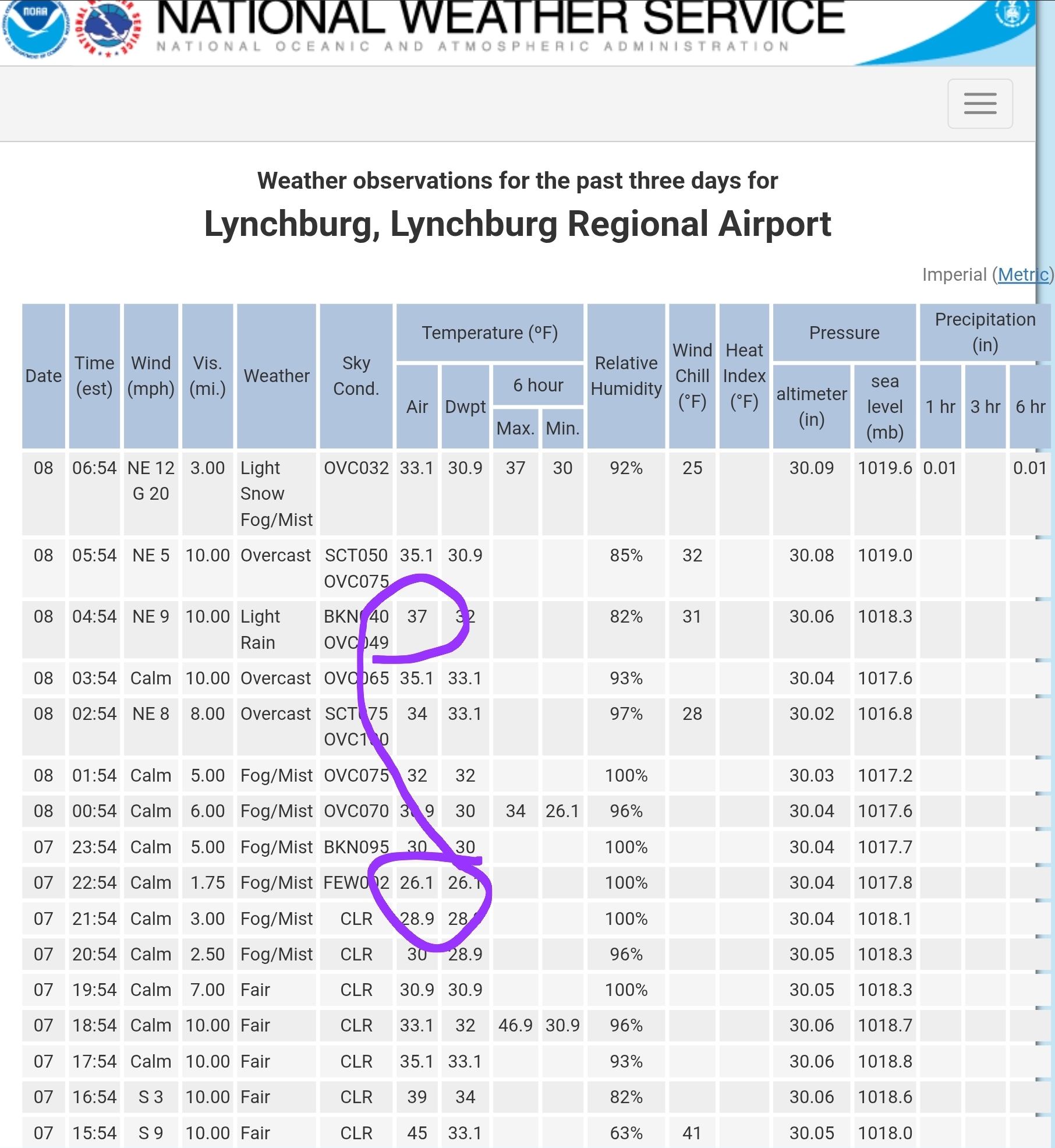
32 and snow here in Forest, maybe a half inch?
Here was the temp spike in Lynchburg from the clouds..

-
1
-
-
Loaded up and ready to go in Bedford county.
-
2
-
-
23 hours ago, eyewall said:
Thank you! I used a DJI Mavic 3 Classic. I agree that is probably the one that came out best. It is actually why I chose Farmville specifically.
Thought that was The High Bridge. Fun place to walk and ride bikes. My daughter just bought a house in Town.
-
1
-
-
12/5 3.2 in Forest, VA
-
About 3 inches down here in Forest. Light snow continues
-
8
-
-
Jan 5-6 event = 2.5 then buckets of ZR
Jan 10-11 event = 2.8
Feb 11-12 event = 5 total with 3.8 snow and 1.2 sleet before bucks of ZR
Feb 19-20 event. 2.0 round 1, 1.5 with ULL passage for 3.5 total.
13.8 on season
Near climo which is 15-16 ish now and fading fast.
-
3 hours ago, Bob Chill said:
Shut off like a switch. 1.8" yesterday and 1.8" today. 2 completely different experiences but hit 3.6" total. Blue sky is in the distance. Should be good photo ops here shortly.
I'm not really that close to climo. 9.3" on the season and modern climo maps tag this elevated area with 13" around smith mtn. I still give this winter a B-B+ grade based mostly on the feels. Multiple cold events, plenty of snow cover days, and lots of fun tracking. If i can hit 13" it's an A-. Below norm DJF with multiple events it's not normal or average. It's pretty rare.
We pulled a 2 yesterday and 1.5 this AM up here in Forest. Fine high ratio powder this AM that melted at the first crack of sun. 3.5 total not too shabby.
-
2
-
-
On 1/11/2025 at 8:57 AM, Ephesians2 said:
1.11.2025 - 2.5"
Total: 5.0"
Another Lynchburger.. I'm in Forest. 2.5 then 2.8.
Total- 5.3
-
1
-
-
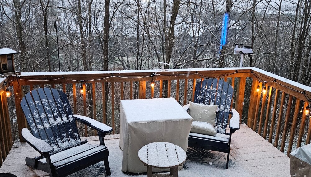
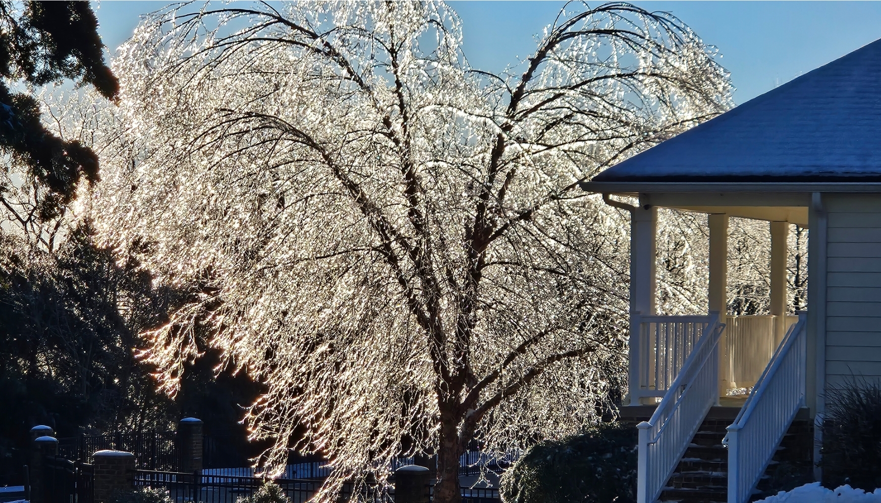
About. 2.5 snow and sleet in Forest, VA then tons of ZR.. had a departing snow shower late afternoon. Would have preferred snow but the trees look phenomenal. Pics not catching the full glimmer from the sun..

-
16
-
-
29 and light snow down here in Forest, VA
-
15
-
-
1 hour ago, WEATHER53 said:
Were any of the 2009/10 real coldies
Hey Howard, I'm doing well- I work FULLTIME telehealth now chatting with my clients. Pretty fun--
I still think about your legendary parking job at G&M's crabcakes-haha. How's life treating you?
-
58 minutes ago, Bob Chill said:
No matter what happens, the WAA piece looks pretty good for the MA (somewhere) not including my yard lol. Things get muddy with the mid and upper lows but that front part has all the ingredients in place for a hot and heavy stripe. Prob not real fluffy though unless mid/uppers crank a little when mid level winds shift.
Not feelin too excited here. Maybe an inch or 3 at best before inevitable ptype problems. Pretty good cad area here though. Especially on our land east of Smith mtn. NE surface flow banks up pretty good and the topography between Smith mtn and Gretna is a forrested bowl. Doesn't scour easy as all. Considering this is my 3rd winter spending time here and I've never seen a plow or the grass covered.... I'll take what I can get and be happy AF.
I'm up in Forest but also have a house in Rocky Mount. Welcome to the hood. You picked the non snowy side of the lake. Weve been looking to consolidate near the and I've already states Goodview was my preferred location:) Marginal events lake warmth will hurt..
-
1
-
-
1 hour ago, WEATHER53 said:
Hey you!
Hey now, Howard. It's been a minute.
-
1
-
-
9 minutes ago, DarkSharkWX said:
this really isnt an anafrontal event anymore, the reason why we're getting sm snow on recent runs is bc of a secondary coastal snow forming and undergoing surface cyclonegenesis which throws moisture nw back into the cold sector, this isnt cold front trying to catch up to precip
This. That 500 low goes negative a low forms over South Carolina
-
2
-

January 2026 Medium/Long Range Discussion
in Mid Atlantic
Posted
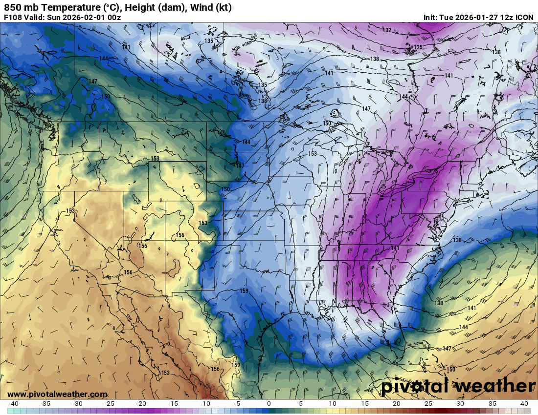
Issue iwth ICON and other models is it catches the low but H85 low is out to sea on the baroclinic zone-- no way to transport any moisture back.
Air is so dry, dynamic can ring out a few fluries?