

Regan
-
Posts
418 -
Joined
-
Last visited
Content Type
Profiles
Blogs
Forums
American Weather
Media Demo
Store
Gallery
Posts posted by Regan
-
-
Yeah and we all should be used to seeing the sliding of totals from release to release anyway. Nothing new. They can still up it too in theory. They did already yesterday. Heck, WRAL have several inch maps floating now and it’s purposeful. Like he just said, people get mad.
-
 1
1
-
-
RAH can say what they want and ride the ride but the mets on tv etc are still saying up to 2 with localized 3.
Also Wake County chose a 3hr early release. I heard most of the board opposed it and wanted to close.
-
2
-
-
Just a rough idea. Could jump up and bite people.
-
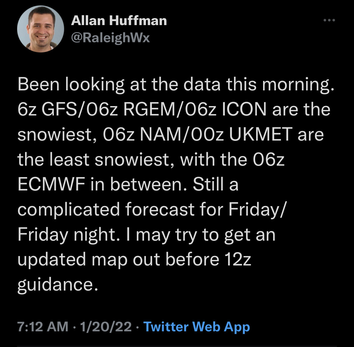
13 minutes ago, kvegas-wx said:
One thing we normally don't have in our favor is ground temps leading up to the storm. Anywhere north of 40-85 in NC is frozen solid. Every flake is going to stick. I expect most all school systems that are on the fence today will cancel by this afternoon now that the Euro is out and slightly increasing totals. This may not be a big dog, but it will certainly be a good dog for many.
Word on the down low is Wake county is leaning to closing after first thinking early dismissal. Given the unknown because we can’t predict when in a 4 hour window it’ll touch the ground, I hope they close. Wake is a massive county with a ton of buses. They share buses between hs, ms, and es so they can’t close at a specific time. Even with an early dismissal it could jump up and bite them. I know k5 that don’t get home til 5 on a regular day because if shared routes.
-
1
-
-
Thanks. That song is stuck in my head now.
-
 1
1
-
-
1 minute ago, blueheels2 said:
For the Triangle I would think it would be a no brainer. Release at 12 to avoid a repeat of the 2004 or 2014 commute disasters.
I hear you. But Wake has a bad history on twiddling thumbs. I’m near the famous Raleigh meme btw. That is right down the road. It was interesting.
-
 1
1
-
-
26 minutes ago, wake4est said:
The WSWatch starts at 1:00pm tomorrow for us in Wake. I would almost guarantee that they will do an early release tomorrow, even though the snow doesn't rally arrive until closer to dinner time
Probably need a 3hr release at the least to get the littles on long routes home by 2ish. I was just told they don’t know because it depends on when it makes it to the ground and they can’t predict that well. That’s a nightmare when it’s expected to stick immediately.
-
1
-
1
-
-
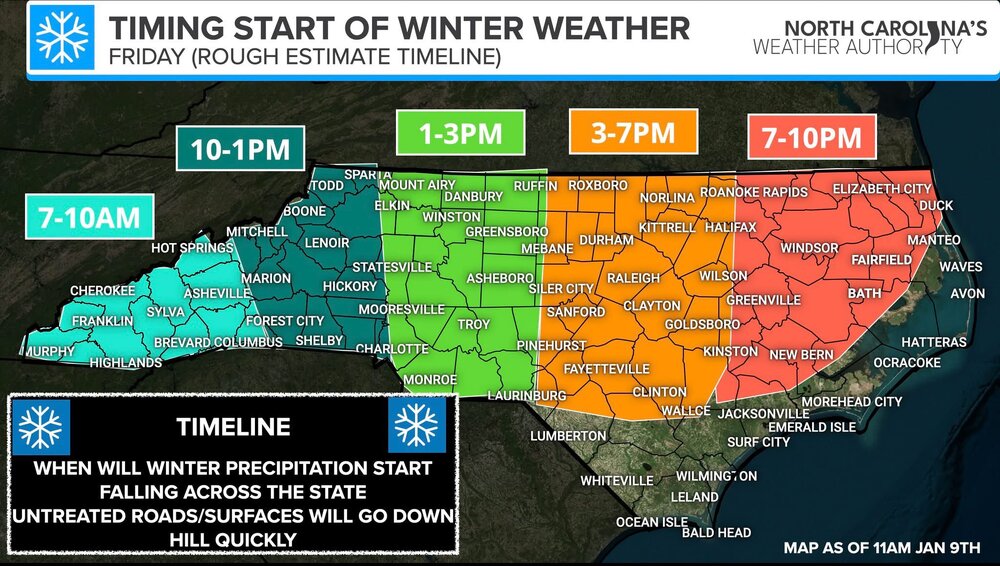
Start time for precip as sparsely reported on some stations still and seems to be a huge window of time still. Seeing anywhere between 3pm to 8pm for Wake. Hope they pin this down better for commutes/schools. Hoping schools bite the bullet and just close early to get kids home. Some k5 don’t get home til 5 or after as well as some charter transportation for k12.
Opinions on start time for Rowan, Guilford, and Wake?
-
2 minutes ago, wxdawg10 said:
My friend..this is a tale as old as time. i'll give you some advice. Always remember that storms will always trend towards a drier, warmer, or northern solution. Those are the default settings. Us folks in the south need to go 3 for 3. Always an uphill battle. Lower your expectations.
I have zero expectations for the weather here. I know how it goes here in central NC. I was born and raised here. I was just saying the freak outs cloud the info. I was making light of it by saying everyone should go to bed. Let it ride.
-
Maybe everyone should just go to bed and show those models who’s boss. Been coming here for years. I have learned a lot and I’m grateful, but the constant doom at the flux is difficult.
-
1
-
3
-
-
1 minute ago, lilj4425 said:
Too late.
 It’s gonna be 70 and sunny at this rate.
You’d think with this bunch. They were just yay over the icon and boom crying again.
-
1
-
-
 Here comes the PM panic attack. Come on guys. Please don’t go near the cliff.
-
3
-
3
-
-
14 minutes ago, StantonParkHoya said:
Mike Maze hates us
Yeah. But we have to expect TV Mets (especially in the RDU area) have to keep it really downplayed because 1. We are in a cursed spot and 2. People irrationally get mad at them like they are supposed to be psychic.
also people notoriously take numbers and lines and colors for religion and measure how far they are from the boundary lines from these color maps. Which, you can’t do. You can’t even take these models completely by visual. But, the public does.
-
Yeah it’s already being taken less seriously online. They too are seeing the H and questioning the seriousness. They aren’t reading the discussion. At least one media guy has latched on to this too.
-
At this rate.
-
-
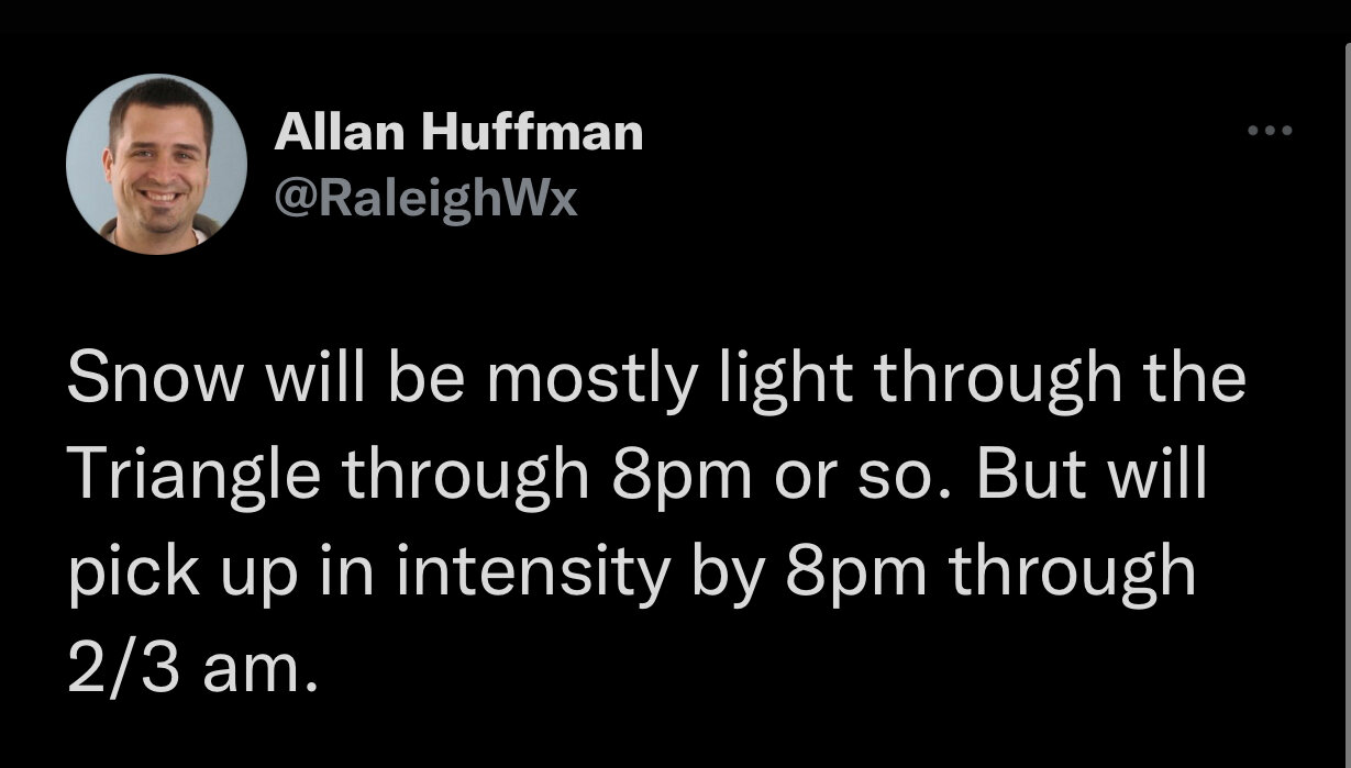
4 minutes ago, Brick Tamland said:
It's coming down but very light. I thought it would be bigger flakes and rates.
Alan says it’ll be light til about 8ish. Something like that. There’s a tweet.
-
1
-
-
I guess it’s still trying to fill in and move N
-
Flurries have almost stopped near Crabtree Mall area, but I know it’s still early in the game.
-
Flurries have begun in Raleigh near Crabtree Mall.
-
-
I feel the classic cliff jump rants coming. Might have to try not to look here for a while. Emphasis on try.
-
It’s a little trippy to see Wral saying 2-5 and stating models saying it could be more. Add the NWS saying 3.8 (3-5). I’m used to seeing conservative numbers until they have to increase them.
-
10 minutes ago, calculus1 said:
I think that since this, a lot of things changed. The tv mets have changed their thinking from this idea above to what the NWS and other private mets/hobbyists are thinking and that’s a central NC and eastward storm. But, we will see.


January 10/11 Winter Storm Potential - May the Odds be Ever in our Favor
in Southeastern States
Posted
Well. Sleet still looks white? Freezing rain makes it shiny? At this point I feel like the models don’t matter because they are still giving us similar ranges in RDU. 1-2 maybe 3. Some of that ice mixed in. Is what it is… Never had expectations of anything. It something frozen.