

das
-
Posts
2,154 -
Joined
-
Last visited
Content Type
Profiles
Blogs
Forums
American Weather
Media Demo
Store
Gallery
Posts posted by das
-
-
1 hour ago, mreaves said:
Hot off the presses from BTV. If I get the 15" shown, it will put me at 93" on the year.
If I get the 14" shown on the map here in Charlotte, it will put me at... 47.9" on the year. Still a stinker.
-
46 minutes ago, powderfreak said:
Thunder snow just north of BTV. Another squall warning issued.
Yep. Second squall of the day. First one late morning dropped 0.6". This one is at 0.4" so far.
-
It’s been 21 days since Charlotte, VT has recorded measurable snow.
-
1 hour ago, MJO812 said:
Jeez

100% of stations are reporting below average in mid-Feb. not sure I’ve seen that before.
-
 1
1
-
-
1 hour ago, Scarlet Pimpernel said:
Folks???
Great screen name, btw.
“There’s nothing quite so bad as that which is not so bad”.
-
 1
1
-
-
6 hours ago, Roger Smith said:
I recall before the larger storm 5th-7th in Feb 2010 there was 7-10 in of snow around Jan 30-31; before that it had been mild with rain around Jan 26th. Then there was a third snowfall event around Feb 10th.
In Clarksburg:. Sorry for the craptastic formatting on this phone
6.1" 30jan10
5.6" 02feb10
28.0" 06feb10
15.1" 10feb10
0.2" 16feb10
0.3" 25feb10 |
-
3
-
1
-
-
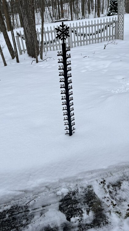
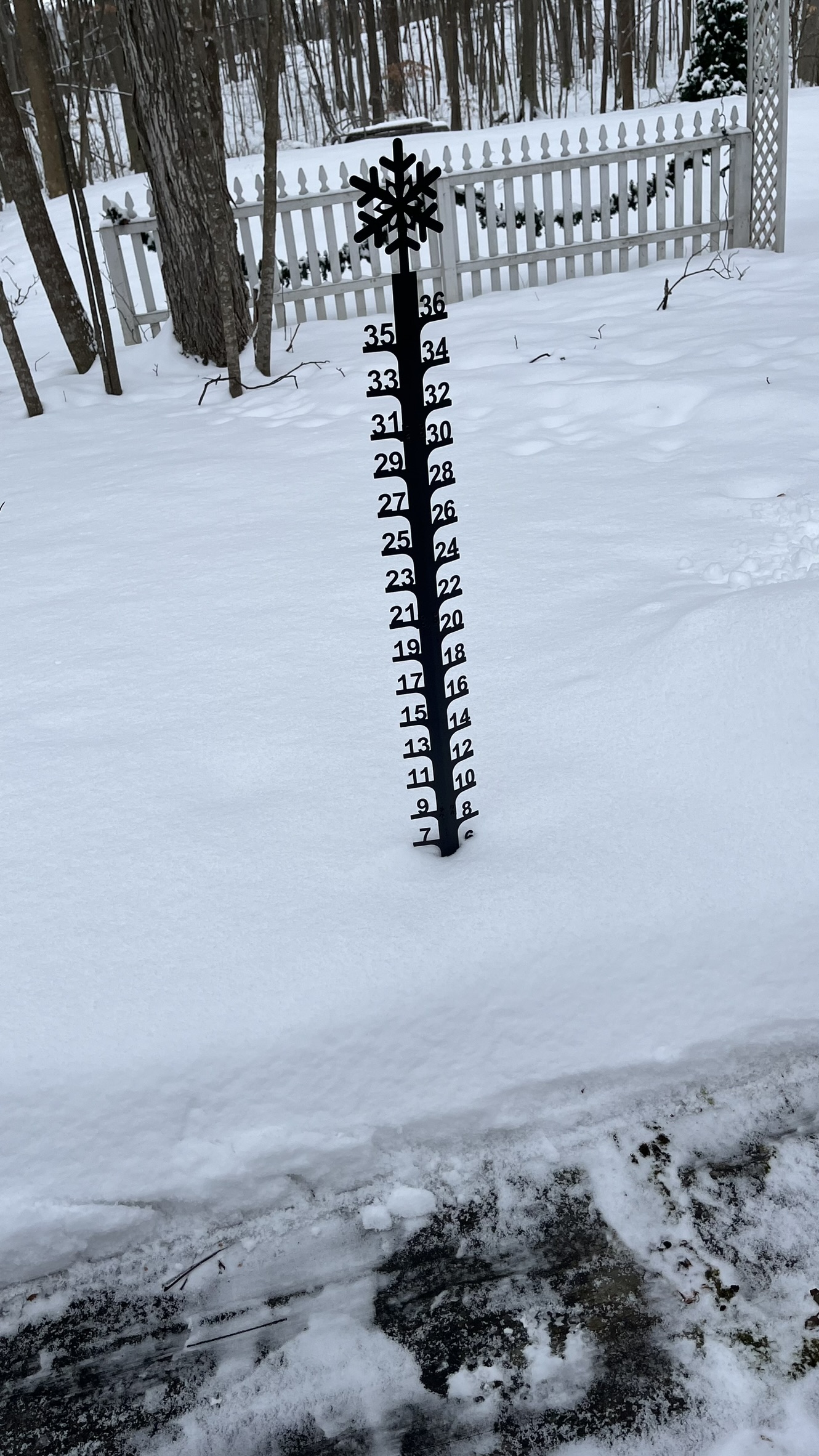
Just shoveled the 2.1" from last night. Season total is 29.0" now. We just went above freezing and it feels like it's 70ºF out there. Bleh. Here comes the big melt. I wonder if any of the 7" OTG here will survive thru Sunday...
-
1
-
-
2.1” last night before the warmup starts in earnest this afternoon. 7” OTG. We’ll see what, if any lasts before cold air moves back in on Sunday.
Charlotte, VT,44.29°N 73.24°W
2023/24 Season
11/1 0.1”
11/9 2.1”
11/19 0.2”
11/21 3.1”
11/26 0.6”
12/4 0.4”
12/11 0.9”
12/13 0.1”
1/8 8.4”
1/9 3.4”
1/11 0.7”
1/14 0.3”
1/16 6.1”
1/19 0.5”
1/24 2.1”
Total: 29.0” -
4 hours ago, Damage In Tolland said:
No one here cares
Um… :slowly raises hand:
-
1
-
 2
2
-
-
Here they come. I’m a little disappointed to be heading to the airport.
-
6
-
-
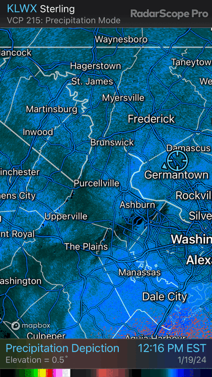
You can see the NW flow streamers LWX talked about in their AFD starting to form over WV. It’ll be interesting to see these extend to the SE over time. Pretty cool.
-
15
-
1
-
-
9 minutes ago, wxmeddler said:
I see some measurements in the LSR's are measuring this event + the previous...

Yes.
-
1 hour ago, Terpeast said:
Snowing better now. Almost moderate. Healthy flakes
I just need to reach 4.5” to get double digits on this season
I just measured 4.0" new. So, I am now over 10" on the season. Just under 7" on the ground with the snow from earlier in the week.
-
5
-
-
7 minutes ago, real said:
Fox 45 Baltimore weather professional just said Baltimore should see it's heaviest snow about 2 p.m. Does that make sense?
The inverted trough modeled on high rez guidance has been hinting at this for a few days. Setting up somewhere between NJ and central MD. They are very small, from a meso perspective and hard to pinpoint but the the forecasters are seeing evidence that it may set up at the southern extent. That'll be the jackpot zone.
-
3
-
-
Just now, Ka60 said:
We just passed 5" in Clarksburg, MD as of 9:15PM 5" SN 26/25
Really? I'll have to go measure again. Mine was a decidedly non-scientific single measurement between meetings in one location next too the house. Thanks for the flag.
-
Just now, 40/70 Benchmark said:
Hopefully we can get a HECS rolling next month.
If we can't get it done this year, then all of the forcing mechanisms and associated indices we've come to trust over the last 30 years will need to be normalized to whatever this new normal is.
-
3
-
-
6 minutes ago, 40/70 Benchmark said:
Glad you guys finally caught a break...enjoy!
I was in VT for Tuesday and down here for this. I am a snow magnet. If you want snow, just invite me over. Payment can be made in beer and snacks.
-
2
-
-
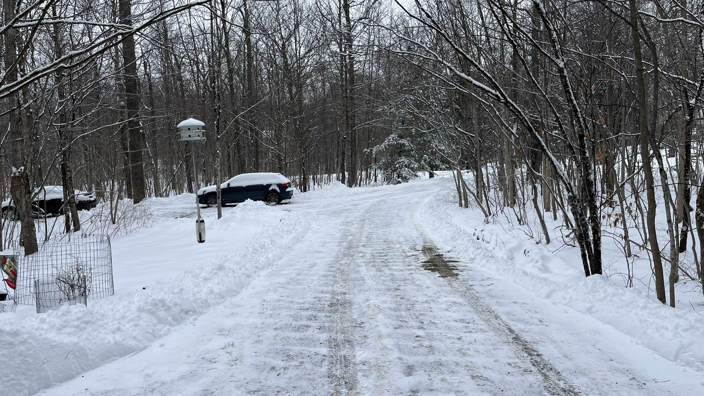
Checking in from the house in Clarksburg! 3.1" new on the ground so far. 26.1ºF and no wind. When I came down on Tuesday, I got to see how a northern airport (Burlington, VT) conducts ops in a snowstorm. It will be interesting to see how DCA is doing when I fly out this evening....
-
2
-
-
Steady, constant light snow since 2pm this afternoon for a whopping 0.3”. No melting, either. That’s just how light the snow has been the whole time.
-
8 hours ago, J.Spin said:
Below I’ve put together the north to south list of what I’ve seen reported for Winter Storm Finn snow totals from the Vermont ski areas. It looks like totals were in the 6” range for the southern ski areas and ±12” along the spine in the central to northern ski areas.
Jay Peak: 13”
Burke: 6”
Smuggler’s Notch: 8”
Stowe: 10”
Bolton Valley: 10”
Mad River Glen: 12”
Sugarbush: 9”
Middlebury: 6”
Saskadena Six: 5”
Ski Quechee: 8”
Pico: 10”
Killington: 10”
Okemo: 10”
Bromley: 6”
Magic Mountain: 6”
Stratton: 6”
Mount Snow: 6”
And, the total for the anti-ski area of Charlotte down here at 284’ in the Valley was 3.4”. A decent front end thump.
-
1 minute ago, dryslot said:
The more time we snow, The less time we rain.
And, the more it snows, the more capacity the OTG snow has to absorb the upcoming rainfall without washing away. In a perfect world, the dryslot cuts off the spigot early.
-
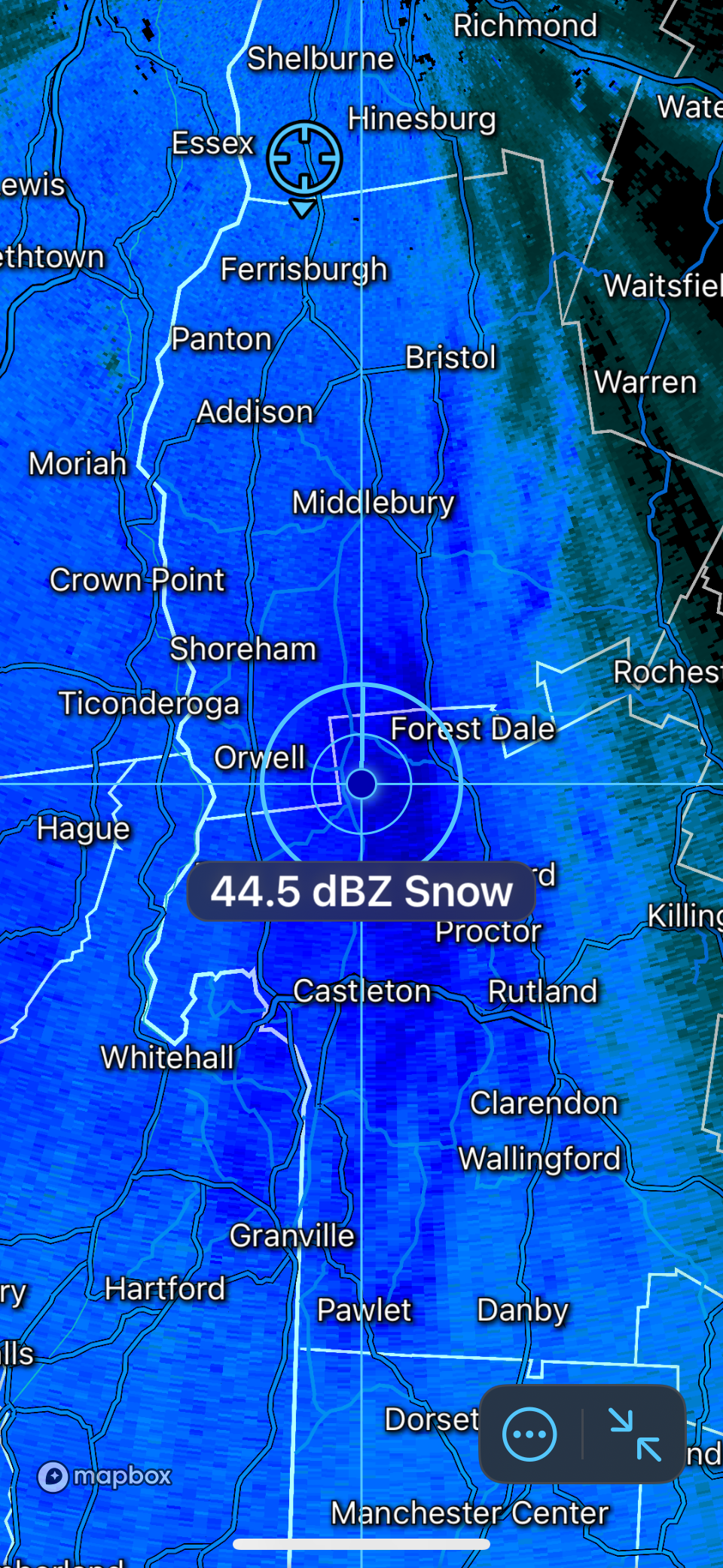
Starting the very first steps of transition here in the northern Champlain Valley. IP/SN mix when rates are low, all SN when it’s ripping. The dual pol CC line is still way south tho.
3.1” storm total so far. Temp up two to 32.1°F
-
36 minutes ago, HIPPYVALLEY said:
Yeah, I’m probably going to hit 2”+ here.
Heavy snow here. Approaching an inch. Ripping returns on the doorstep.

-
6
-
-
Steady, light snow for the last hour here in the Champlain Valley. 29.4ºF after a high of 30.1ºF. Winds ticking up to SE at 13mph.


The Congrats Dendrite Deck Destroyer 3/23-3/25 obs discussion
in New England
Posted
I know, right? What an incredible 2 weeks up there. From 40" to possibly 100"+ in 14 days. And, it is / will be super high water content pack too so it'll have real staying power. This storm is like a day or two late for them to catch the 2018-19 season...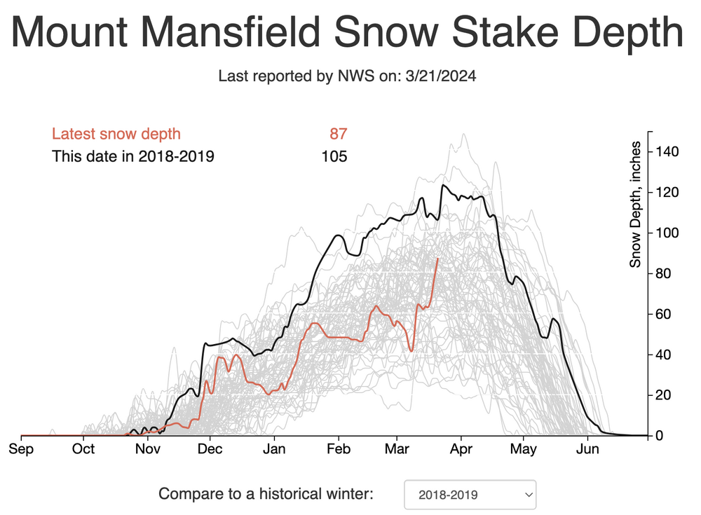 ch the incredible