

twim19
-
Posts
20 -
Joined
-
Last visited


-
Southern MD / Lower Eastern Shore weather discussion
twim19 replied to AnEndlessMaze's topic in Mid Atlantic
Easily 10 to 12 for me. I haven't been out to measure yet, but based around surrounding spots and the rate it is still coming down, we'll get there. Told my kids to remember this one.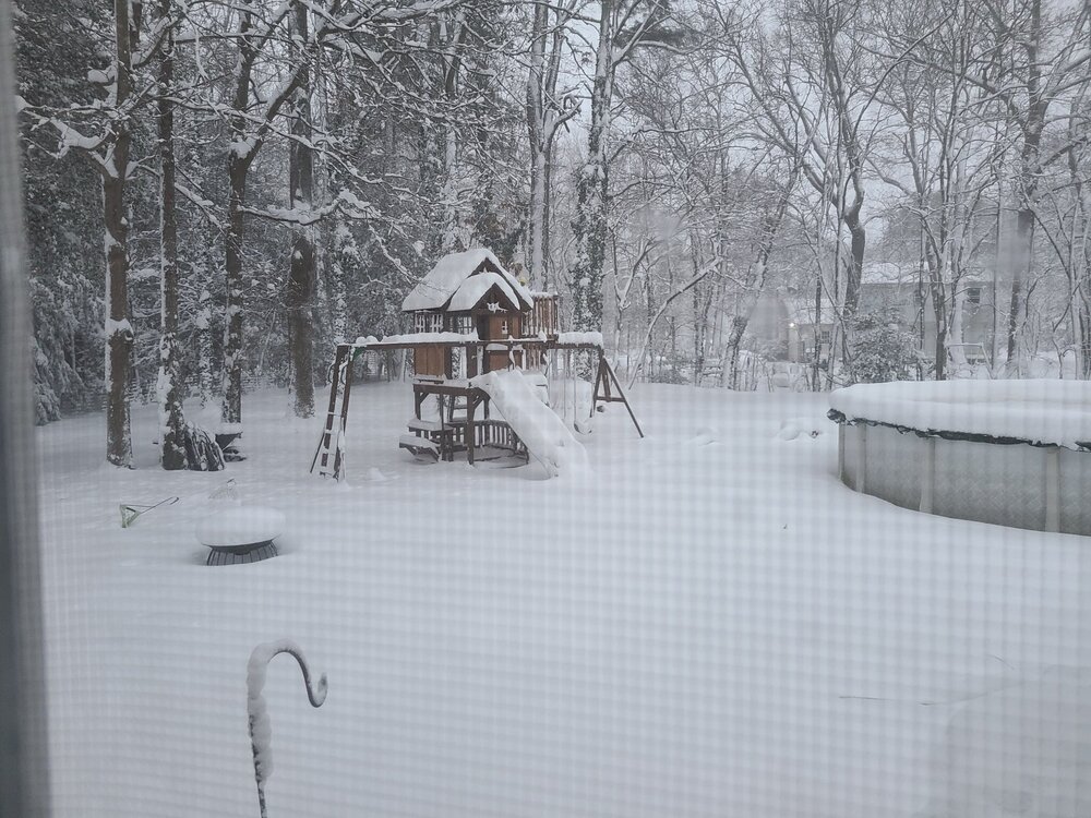
-
January 28-29 2022 Miller abcdefu Storm Obs/Discussion
twim19 replied to mappy's topic in Mid Atlantic
Two more Maryland counties under Blizzard warning. Wicomico and Somerset have been added to Worcester. -
Southern MD / Lower Eastern Shore weather discussion
twim19 replied to AnEndlessMaze's topic in Mid Atlantic
Wicomico and Somerset thrown in there as well. Trying to remember the last time we were under a Blizzard warning in Salisbury. . . Projections up to 8-12 now too. -
Southern MD / Lower Eastern Shore weather discussion
twim19 replied to AnEndlessMaze's topic in Mid Atlantic
Yeah, yesterday when the WSW was issued, it was for 5-10. Before I went to bed it was 6-11. Now it's 6-12. Alex Seymore is pretty bullish too, so I'm game. Off topic: Your signature cracks me up. I've been lurking in weather forums for about a decade now (How I miss the Accuweather forums) and you are spot on. -
January 28-29 2022 Miller abcdefu Storm Obs/Discussion
twim19 replied to mappy's topic in Mid Atlantic
One of our local stations.
-
Southern MD / Lower Eastern Shore weather discussion
twim19 replied to AnEndlessMaze's topic in Mid Atlantic
I too am on the east side of town and am expecting a foot. The trends have seemed to be moving towards more, not less and now with the Blizzard warning for OC, I suggests a bigger storm. Fortunately, I don't have any reputation to protect and so I can make these outlandish claims and let Dan and Co. keep putting out their conservative estimates.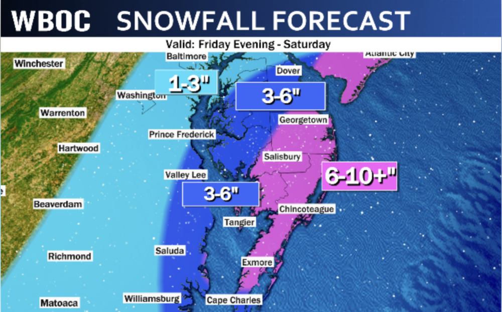
-
Southern MD / Lower Eastern Shore weather discussion
twim19 replied to AnEndlessMaze's topic in Mid Atlantic
I was a teen for the blizzard of '96, but I can keenly recall watching the news the night before the storm hit and BBK (our local legendary forecaster who has long since retired) came on to tell us that we were about to get hit with a major blizzard. I wasn't following models or anything at the time so I don't know if his not telling us sooner was because he didn't know or he was being conservative--I just remember it feeling like a surprise snow storm. -
Southern MD / Lower Eastern Shore weather discussion
twim19 replied to AnEndlessMaze's topic in Mid Atlantic
This storm has been great for "We should have a pretty good idea with the next set of model runs" only to have no idea after those models run. Could we get a little consensus, please? We almost had it last night with the 0z until the GFS was like "HAHAH" I wish Alex were joking, but flurries to 2 feet sounds about right (though I'm more confident the lower shore and beaches are still going to easily break warning criteria). -
Southern MD / Lower Eastern Shore weather discussion
twim19 replied to AnEndlessMaze's topic in Mid Atlantic
Euro seems to have simmered down. Still would be a very nice storm for most of Delmarva, though the trends have me worried. Onward to the 18z NAM. -
Southern MD / Lower Eastern Shore weather discussion
twim19 replied to AnEndlessMaze's topic in Mid Atlantic
Puking snow here. 2inch/hour, I think. -
Southern MD / Lower Eastern Shore weather discussion
twim19 replied to AnEndlessMaze's topic in Mid Atlantic
Moderate flurry started in SE salisbury (near airport). -
Southern MD / Lower Eastern Shore weather discussion
twim19 replied to AnEndlessMaze's topic in Mid Atlantic
Yeah, saw it posted in the accuweather forums, I think. There's something about this storm that makes me think it's going to veer cold. That something is probably the snow weenie in me -
Southern MD / Lower Eastern Shore weather discussion
twim19 replied to AnEndlessMaze's topic in Mid Atlantic
Hugging that Euro. Think the last run kept the 850s off the coast the entire storm. Only model that's show big accumulations for SBY for three (or more?) straight cycles. -
Southern MD / Lower Eastern Shore weather discussion
twim19 replied to AnEndlessMaze's topic in Mid Atlantic
12z GFS, NAM, CMC, and Euro. I think it looks good a good bet that the 'Bury gets buried. Euro: http://forums.accuweather.com/index.php?act=attach&type=post&id=277655 -
Southern MD / Lower Eastern Shore weather discussion
twim19 replied to AnEndlessMaze's topic in Mid Atlantic
The little system that's coming across tonight might end up surprisingly robust. Coming more south than clippers usually do and going right across a warm bay.


