
amt5626
-
Posts
50 -
Joined
-
Last visited
Content Type
Profiles
Blogs
Forums
American Weather
Media Demo
Store
Gallery
Posts posted by amt5626
-
-
Snowing here in Strongsville. Picking up in intensity by the minute. Really good last minute trends here for us. Thinking we easily fall into the 6-10, locally more where the backend and lake effect snows hit.
-
6 minutes ago, Indystorm said:
1000 mb surface low at present in sw OK with pressure falls ne to Cape Girardeau MO per SPC mesoscale. Is this thing coming farther north than expected? I originally saw a PAH to EVV track. And SPC still has a slight risk of svr down south for tomorrow....more than today's marginal risk. Am concerned like Jack on how this might affect the system moisture wise particularly with deformation snows.
That isobar orientation looks in line with short-range guidance. You would think that's where she's headed, but most models show it taking a number of jogs eastward as it tries to gain latitude.
-
Just me or does ridging not looking as strong over eastern Canada at the moment as some models had? Most had the 1032 line stretching out pretty far east by 0Z tonight, but it is roughly a couple hundred miles or so to the west right now...
-
 1
1
-
-
RGEM came in a bump south. Also had to initialize the low a bit southwest of it's forecast point for 18z. Wouldn't be surprised to see the good 12z runs flip to less favorable 18z and 00z runs again. Can't buy any consistency with this storm. Wish everyone on here good luck.
-
 1
1
-
-
FWIW, looking at 16 UTC SPC mesoanalysis, the surface low is actually a bit stronger compared to most models. Seems lock step with the 12z RGEM in placement, but actual low is stronger. Again note that the low placement isn't everything here. It's just a factor that can certainly help us out.
-
What a roller coaster ride this has been. It seems each 0z suite, things trend worse for us, then readjust at 12z. It's been a nightmare to forecast. I think 6-12 is a good bet, as well. Could even be more, could even be less. Time to start now-casting.
-
18z GEFS are not looking too good. Definitely a push to the south in the mean, and it appears there is quite a bit more spread than at 12z.
-
FV3 appears to show more phasing. Awaiting precip maps to see what it means for the surface.
-
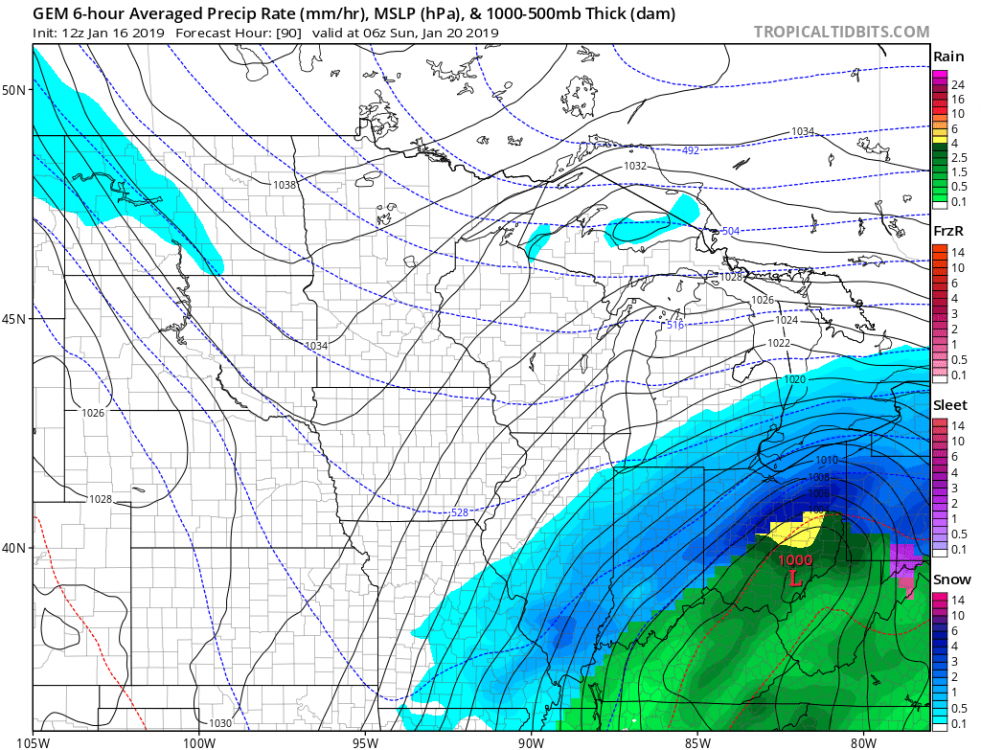
Quite a bold forecast by CLE. Could see these totals verifying, though, especially with today's trends. Would like to see models bump up the QPF some as we get closer. It seems that the heaviest snow should set up around or a bit south of I-76 and then areas pointing east.
-
Euro took a good step back to the north for a change. Hopefully the EPS and 0z run keep up the trends so far today. Still want to see another good 50 mile shift by the Euro and we should be looking pretty good.
-
0z guidance so far not really telling us much. Everything generally holding onto their respective solutions with small adjustments here and there. Tomorrow should be much more telling.
-
2 minutes ago, Jim Martin said:
12z Canadian takes a hard turn to the left...
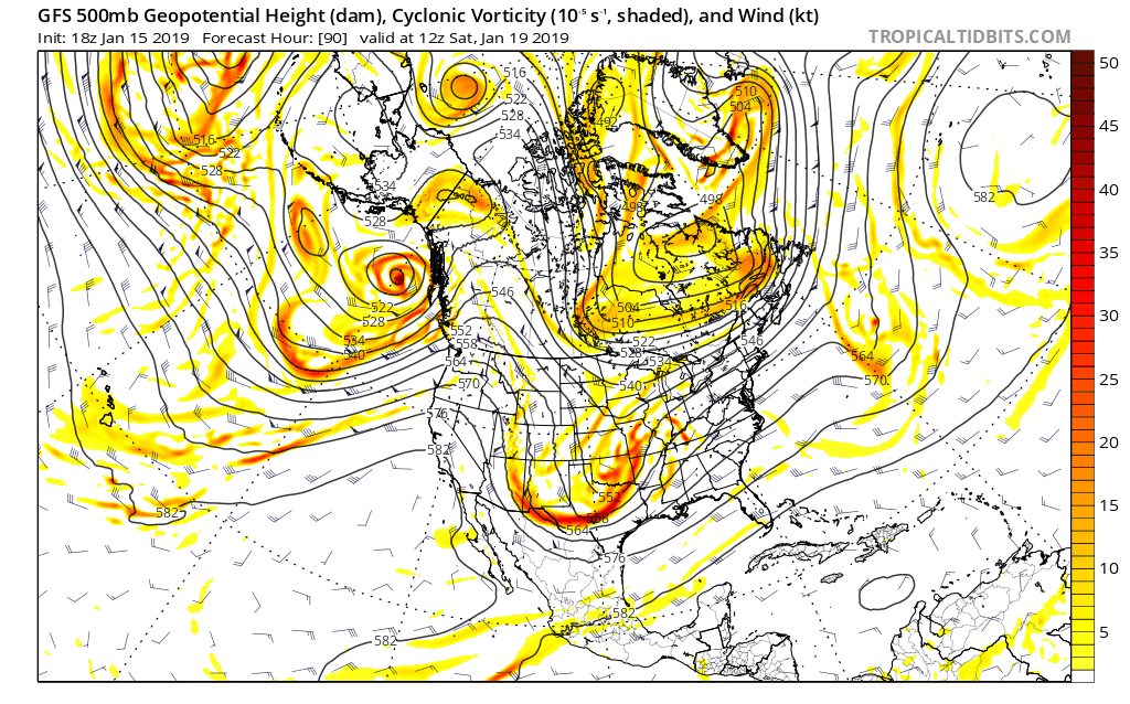
Actually looks like the northern branch trough is trending more negatively tilted in recent runs, preventing a cleaner phase. Snow axis looks to shift south a tad, but more QPF in general. Likely due to the more neutral southern branch producing a somewhat stronger storm.
-
0z GFS bringing the southern branch SW energy a good bit further south, with the northern stream lagging behind some. Not looking good this run.
Edit: By far the worst run of the GFS for the southern Great Lakes yet. Advisory / borderline warning snows at best for most of OH.
-
2 minutes ago, ChiTownSnow said:
Looking at partial sampling by the models early Thursday?
Clipper system should have some sampling in tonight's runs. The southern branch of the main event looks to be onshore Thursday.
-
1
-
 1
1
-
-
Can't post the maps, as they are from a subscription service. Definitely an increase in members to the south, with a majority cluster similar to the 12z.
Still in the windshield wiper phase. Models may start to react in some interesting ways to new sampled data over the next couple days. Would be awesome to see some good homestretch adjustments.
-
58 minutes ago, NEOH said:
Everything is still on track. Any small changes in track are noise at this point... and most important to those riding the edge. Not saying things couldn't change but continuity is really good right now.
As soon as we start feeling comfortable, the 18z EPS show some more of the southeasterly solutions, bringing down the mean a bit and shifting it southeastward. See what 0z says later tonight. Nothing crazy now, but if we see another tick in the same direction, might be a cause for concern.
-
Agreed. Still like where we are right now. Wouldn't really pick anywhere else to be at the moment, as exact details are too hard to pinpoint. 18z GFS came a bit north for what it's worth. Mix line even gets pretty close to the lakeshore. Meanwhile, EPS seem locked in last few runs. Widespread foot + mean for all of N OH on the 12z. Expect the operational Euro to bounce around the EPS suite at this point as small upper level changes develop due to timing/speed of the northern and southern waves.
-
1
-
-
4 minutes ago, NEOH said:
Thanks for the post. Great to have a met in the area. Going to be a long week of model watching. Would the weaker clipper allow for more amplification of the weekend storm?
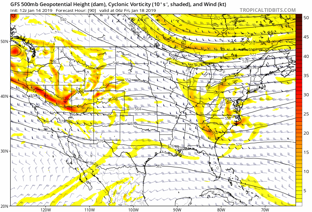
This would appear to be the case. The weaker clipper is allowing for higher heights in the East, thus amplifying the trough. Another player will be the pressing high to the north. If it trends stronger, than the baroclinic zone should strengthen and cold air should stay in place longer, helping the southern areas where the changeover will/may occur. The 0z Euro appears to show a stronger "banana high" like the GFS depicts encapsulating this storm.
Note how the heights along the East Coast are gradually getting higher in the last four GFS runs as the clipper moves by us:
-
Hey all,
Long time lurker here. Haven't posted in quite some time. With this storm potential, figured I'd try to post in here a bit more!
Quick update on my whereabouts. Just graduated last spring from Penn State with a degree in meteorology and currently working on my masters at SUNY Albany. Loved being in school so much that I wanted to stay for a couple more years!
Anyways, the European is almost unbelievably good for our area. Looking at the ensembles further solidifies the likelihood of big snows in northern OH. Recent GFS runs aren't half bad either, easily giving a foot + for all of us here. Furthermore, the lake effect behind this will also be something to write home about.
And yes, those monstrous QPFs are all snow in the north central and western parts of the state. Temps at the surface will be in the mid 20s for most of the heaviest snow, crashing into the teens near the back portion. This should lead to decent ratios. Will be fun to look at model soundings as we get closer in time to the event.
The energy associated with our pesky Thursday evening/night clipper is just off the West Coast right now. Once that gets fully sampled tomorrow, we should have a higher degree of certainty in the weekend system. Rooting for a weaker clipper.
-
1
-
-
SPC has us under an enhanced risk for severe storms later this evening/overnight. Thoughts on what may be in store for us? Seems that they shifted the focus further south.
-
Funny to see all of the schools closed for tomorrow due to the cold. Sure it will be pretty cold, but not nearly as bad as last year. Hopefully the kids can have some actual "snow" days this winter.


Northern Ohio Obs/Discussion Part 2
in Lakes/Ohio Valley
Posted
Just for giggles, Euro absolute crushes northern OH. Widespread double digit totals, all shifted north quite a bit from last night's run. I'd say the ceiling has definitely raising here. Would love to crack double digits, a foot + would be fantastic.