

Jim Martin
-
Posts
2,469 -
Joined
-
Last visited
Content Type
Profiles
Blogs
Forums
American Weather
Media Demo
Store
Gallery
Posts posted by Jim Martin
-
-
-
-

Severe Thunderstorm Watch being considered for portions of Michigan, Indiana, and Ohio.
-
lotchat 2021/09/07 2:39 PM iembot
2 SE Bull Valley [Mchenry Co, IL] TRAINED SPOTTER reports TSTM WND GST of M68 MPH at 1:29 PM CDT -- MEASURED ON PERSONAL WEATHER STATION. -
11 minutes ago, WaryWarren said:
I'm in Sycamore, reporting for duty.
Severe Thunderstorm Warning just issued for the Sycamore area.
-
 1
1
-
-
Storm near Muskegon warned for baseballs and 70 moving east 65 MPH. Tornado Warning Clare County Michigan as well.
-
grrchat 2021/09/07 2:03 PM iembot
Reed City [Osceola Co, MI] PUBLIC reports TSTM WND DMG at 1:53 PM EDT -- TREES AND POWER POLES SNAPPED...NICKEL-SIZED HAIL ALSO OBSERVED.-
1
-
-
Storm up near Reed City Michigan is warned for baseballs and 60. Movement is east at *70* MPH.
-
-
-
-
-
-
-
-
-
lotchat 2021/08/09 4:31 PM iembot
1 NE Rockford [Winnebago Co, IL] PUBLIC reports HEAVY RAIN of 1.82 INCH at 3:14 PM CDT -- PRIVATE WEATHER STATION REPORTED 1.82 INCHES OF RAINFALL IN 20 MINUTES JUST NORTH OF DOWNTOWN ROCKFORD. RAINFALL ONGOING. -
-
-
-
-
-
 12z
12z
12z 3km NAM Significant Tornado Parameter for Thursday afternoon.
-
 1
1
-
-
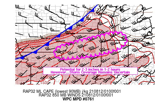
From NWS Cleveland in their latest AFD.
2021 Short/Medium Range Severe Thread
in Lakes/Ohio Valley
Posted
Tornado Warning for Will County south of Chicago through 330 PM CDT.