Joshfsu123
-
Posts
585 -
Joined
-
Last visited
Content Type
Profiles
Blogs
Forums
American Weather
Media Demo
Store
Gallery
Everything posted by Joshfsu123
-
Had a little melting/compaction earlier, but just measured 9.4 inches for the storm (SE DC - Fairlawn - Randle Highlands). That'll be my final measurement. Wouldn't surprise me if I had over 10 inches overall without the slight melting that occured this afternoon before the coastal low got going. 28/27 - temp is dropping, as the glacier starts to form overnight.
-
8.8 inches as of 6:30pm (SE DC - 20020) - hoping for a solid 9! 29/29
-
Up to 7.3 inches now for the storm, as of 4:30pm... with heavy, big flakes back currently in SE DC (20020). A little over an inch of snow in the past hour. Love the rates! Roads/Sidewalks all covered again... temp continues hold steady, at 29.
-
1/2 inch in 30 minutes... still snowing heavily... up to 6.7 inches (SE DC - Fairlawn)
-
Best snow of the storm by far... huge flakes, coming down at a nice pace. Everything sticking... sidewalks and roads almost completely white again. 29/29 6.2 inches as of 3pm
-
Accumulating nicely in SE DC again. Really solid band...
-
Gotten darker... no more sleet/freezing rain... just large flakes as this new heavier snow moves through in DC.
-
30/29 Things are definitely melting a bit... but that's just gonna make the refreeze worse tonight when it drops down to 25. Just light pixie dust flakes atm in SE DC
-
Nice, big, accumulating snowflakes in SE DC. Adding up quickly.
-
29/29 but doesn't feel that cold. Light snow showers atm but the flakes get much larger from time to time when stronger returns push through on radar. 6.1 inches
-
Yep, snowing nicely again. And looks like more coming from the south.
-
5.7 inches at 9am (SE DC - 20020) 28/28 Still snowing, even under very light returns at the moment. Hoping that band to the south holds together and moves into DC in the next hour.
-
5.1 in SE DC (20020) as of 7:30am
-
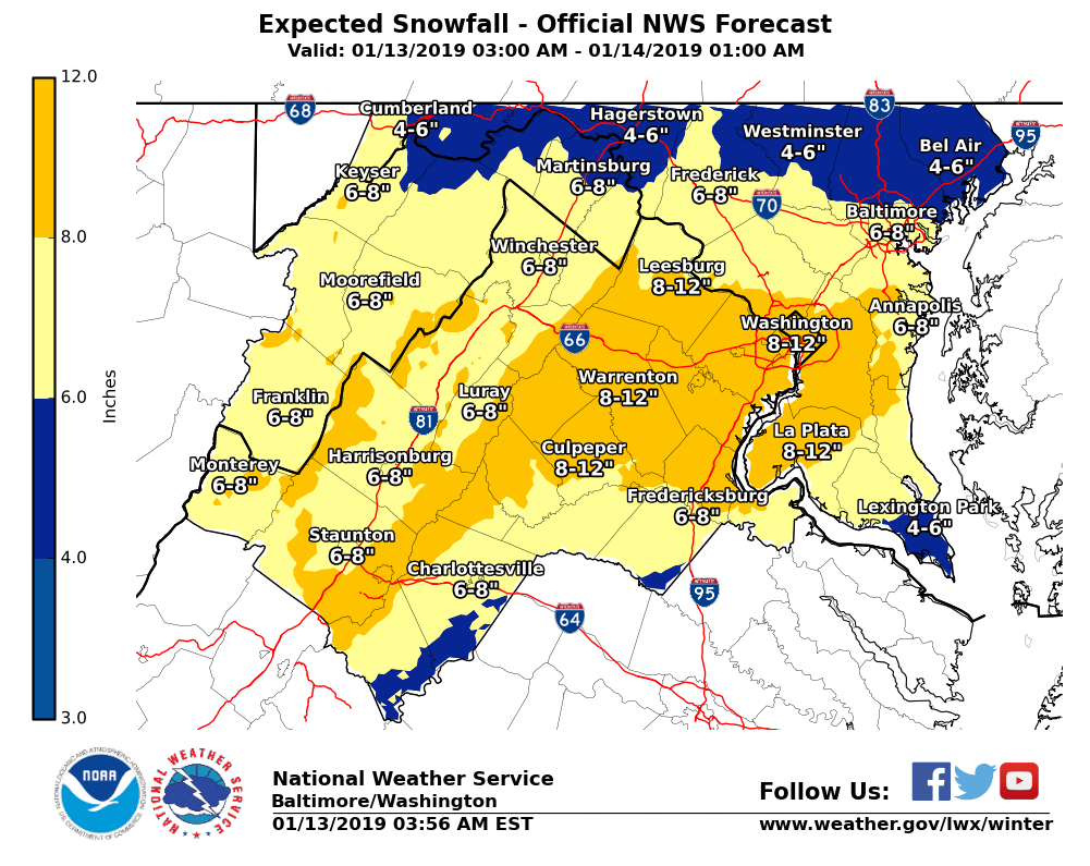
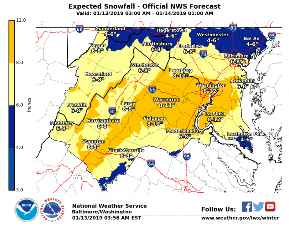
New update from the NWS around 4am ET.
-
Looks like marshmallows everywhere... 3.6 in SE DC (20020) as of 3:30am Cooled down a bit the last few hours... now 28/28
-
Same here in SE DC - roads have caved with this current band.
-
30/29 and snowing - perfect Winter night.
-
Deck and sidewalks caved. Roads just wet so far... but starting to look a little white. Temp has now dropped below freezing. 31/25
-
Light snow has arrived... no longer flurries in SE DC. 33/24
-
Very light flurries have started in SE DC 34/20
-
28/19 SE DC - nice, cold morning!
-
31/18 in SE DC