

WeatherFox
-
Posts
1,412 -
Joined
-
Last visited
Content Type
Profiles
Blogs
Forums
American Weather
Media Demo
Store
Gallery
Posts posted by WeatherFox
-
-
-
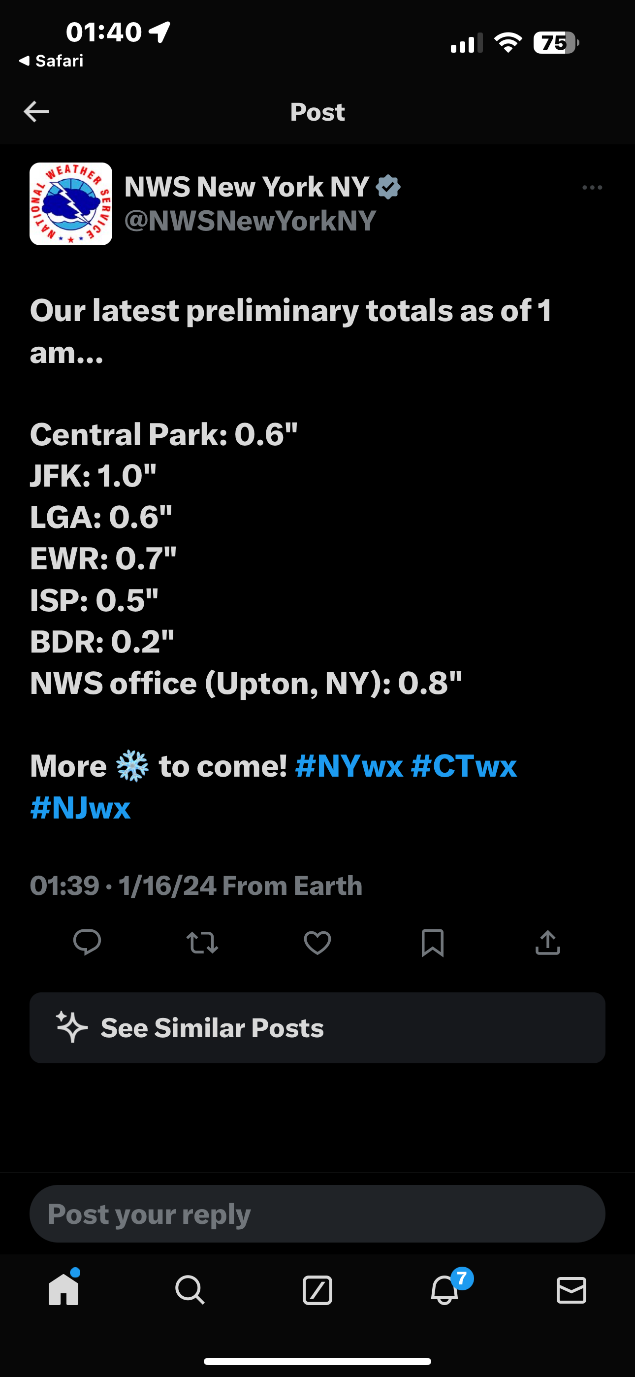
NWS preliminary snowfall 1am at Central Park
0.6
-
 2
2
-
 1
1
-
-
The trend is not your friend.
-
-
5
-
2
-
-
Sat-Sun June 4-5, 2022...The upcoming weekend wl remain subject to approach of an
area of disturbed weather presently taking shape over the western
Caribbean. NHC projections have a "High" chance of development
into a named system by the time it nears S FL on Sat. With an
anticipated track presently near to south of central Fl, local
rainfall projections are largely subject to how organized the
system wl become by the time of closest point of approach to the
area during this weekend. A rather sharp rainfall gradient is
possible N-S over the peninsula should the system become more
organized, and/or a track further south than currently advertised.
A loosely composed baroclinic/hybrid system would potentially
serve better prospects for local wetting rains, and with
anticipation a NHC developed track and intensity forecast wl be
used as baseline by late this week, future wind/rain forecasts
wl remain subject to revision.
-
Just before my 4th Birthday, and contributed to my love of SNOW!
-
1
-
-
This will be a nowcasting event. Tho, Don's post shows increased and expanded potential.
-
4
-
-
33 minutes ago, CPcantmeasuresnow said:
The Central Park total of 5.5 is at 7AM, logic says they surpassed at a minimum 6 inches?
Of course since they won't measure again until 1:00 PM anything that fell after 7:00 am will be treated as if it disappeared into another dimension.
NWS bumped Central Park a tab.
Preliminary Snow Totals - January 7, 2022
❄️LaGuardia: 9.7"
❄️Bridgeport: 8.4"
❄️Islip: 6.6"
❄️JFK: 6.2"
❄️Central Park: 5.8"
❄️Newark: 5.2"-
1
-
1
-
-
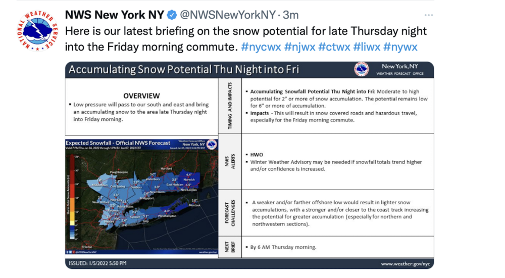
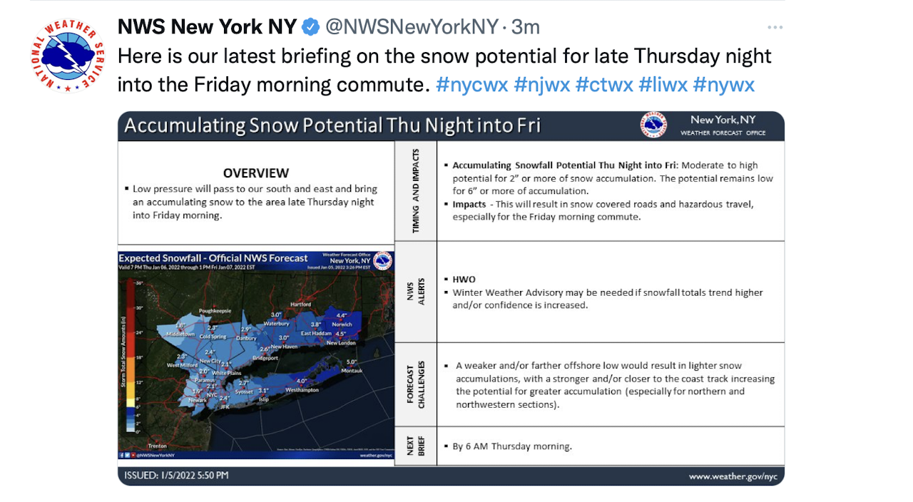
Here the latest NWS briefing on the snow potential for late Thursday night into the Friday morning commute. #nycwx #njwx #ctwx #liwx #nywx
On Tweeter
-
50 minutes ago, jfklganyc said:
Help me learn…
Why are you holding the GFS is such regard after the last two storms? It seems that it has been quite bad this season
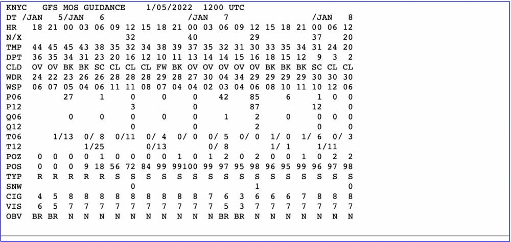
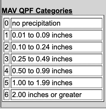
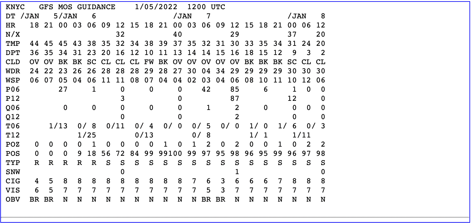
Model Output Statistics (MOS), were a strong resource for forecasting surface weather parameters temperature, dew point, winds, precipitation, etc. I understand the National Weather Service looks to phase some MOS out in the future.
-
1
-
2
-
-
2 minutes ago, MJO812 said:
It's going to be cold enough to stick everywhere
Agree, by KNYC I'm referring to Manhattan where it's mostly sidewalks, streets, cars, "urban heat Island and the snow is expected to be light.
-
1
-
-
After reviewing the 12Z MOS for KYC, I'll go with 1-2" mostly on any grass and car tops. Drive safely if out on the road during the period of inclement weather.
-
11 minutes ago, NEG NAO said:
Anybody else notice the wide range of temps on the 10PM OBS ?
Radiational cooling--clear skies and calm winds.
-
19 minutes ago, NEG NAO said:
where is the rest ? where does the 2 LP's track ?
Out to sea, but my guess at this point is 2-4" for NYC.
-
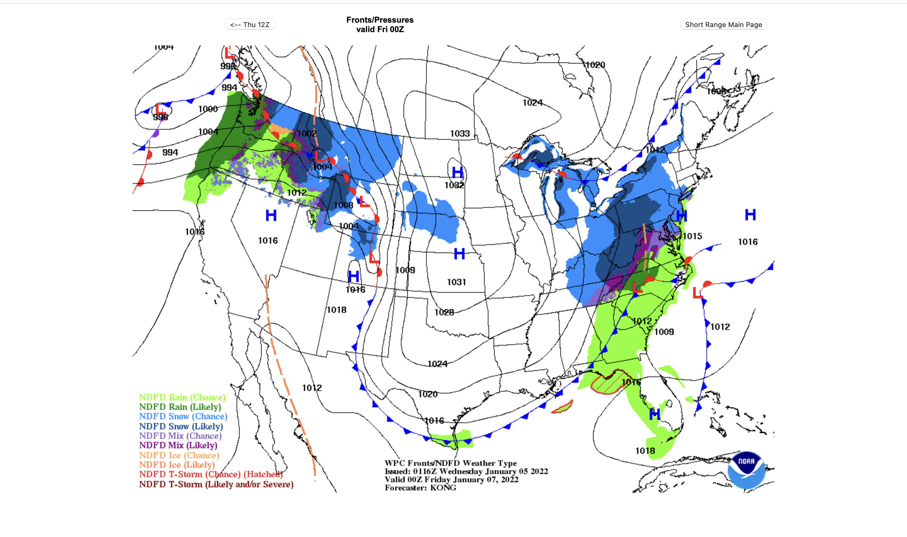
This Weather Prediction Center prog hmm for the NYC area.

-
-
-
42 minutes ago, eduggs said:
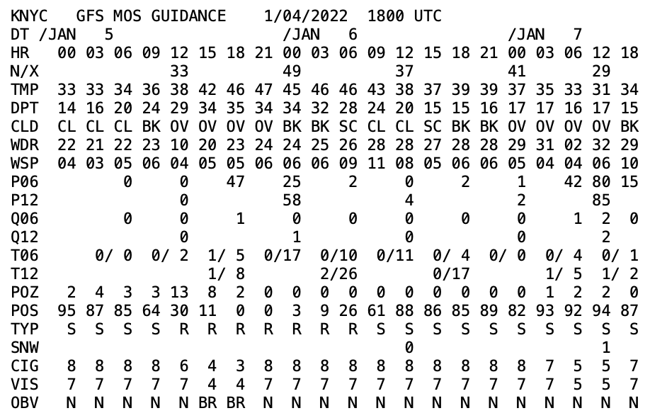
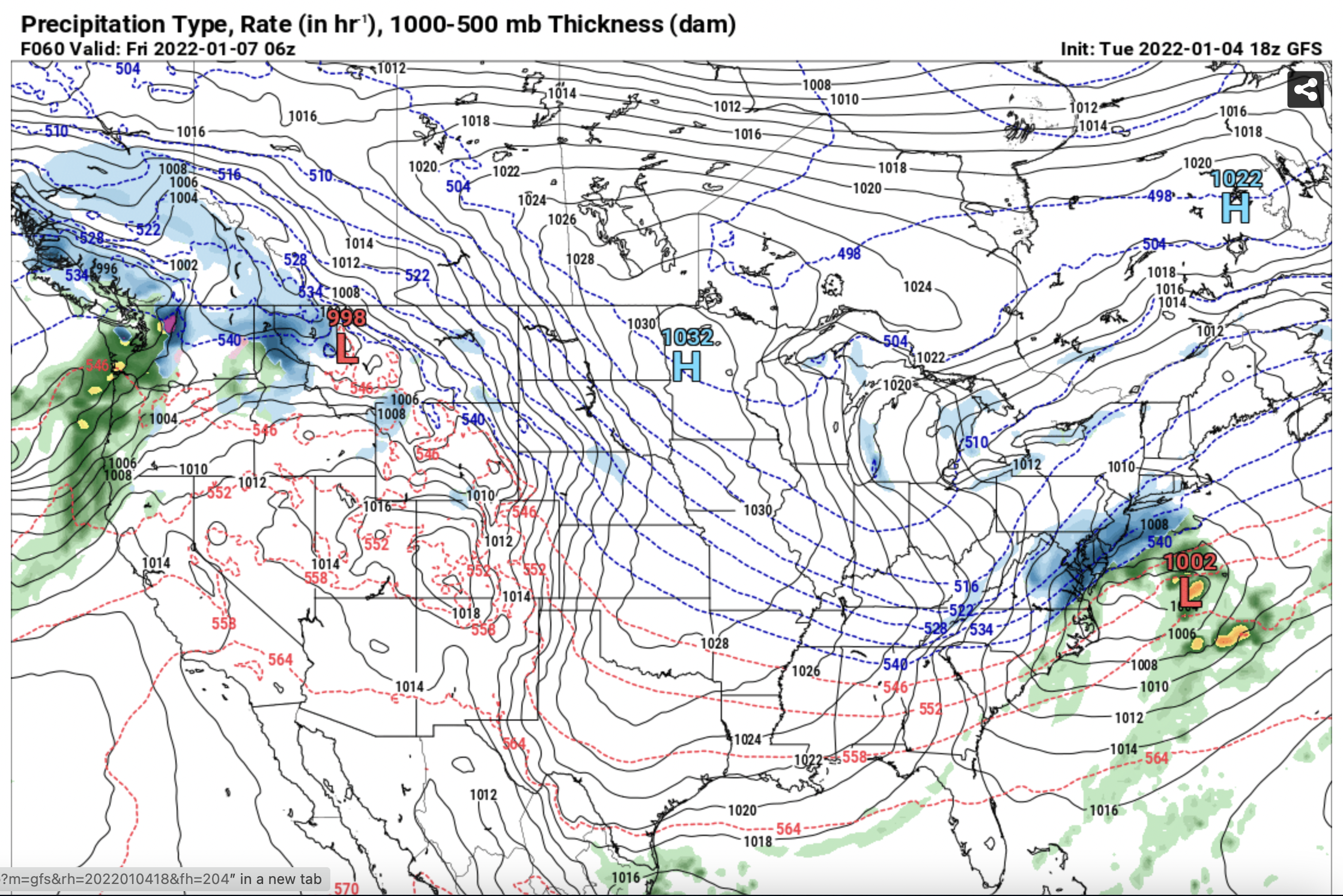
They had a massive push of GOM moisture out ahead of a robust and sharpening southern stream wave. The Thursday night event will not have that. We'll have to do more with less. Ratios should be much better, but we shouldn't be expecting .3" liquid hourly QPF totals this go around.
-
24 minutes ago, MJO812 said:

Looking good, will see what happens. Still plenty of time and models to evaluate, etc..
-
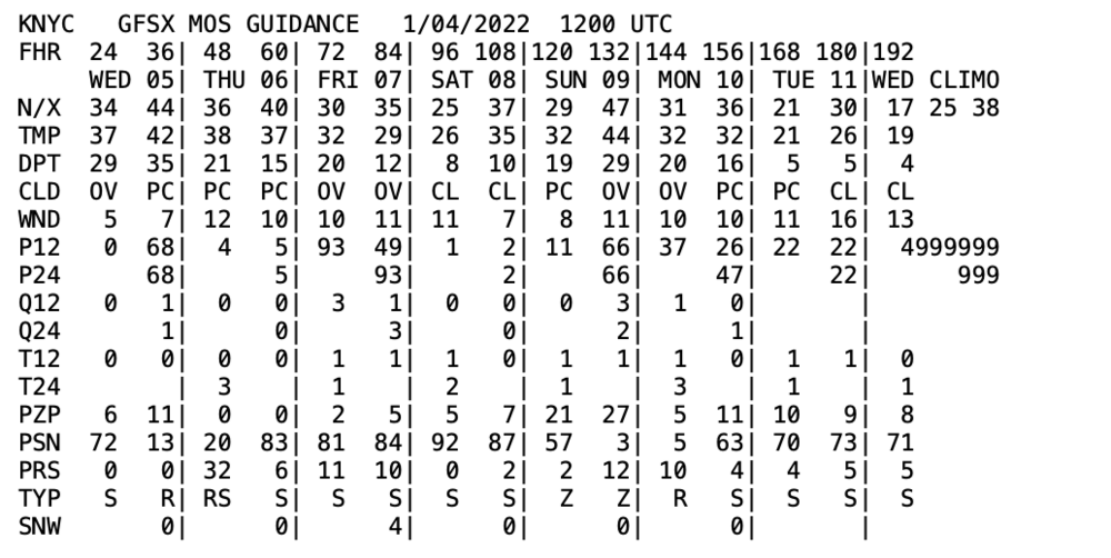
Model Output Statistics (MOS) for New York City, NY. Thursday PM to Friday AM-Q24 numbers of 1 & 3-light snow potential.
-
With 48 hours out model watches look for "the trend is your friend" to forecast the potential snowfall. I personally was taught MOS versus dynamic models for short range weather forecasting.
-
1
-
-
28 minutes ago, Doorman said:
East of the 40/70 Benchmark at this time.
-
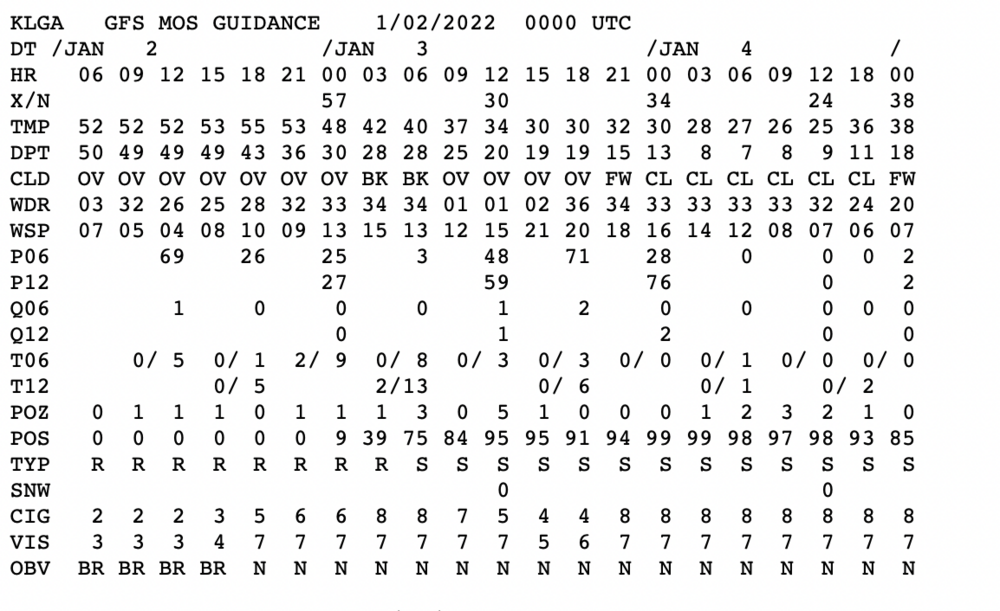
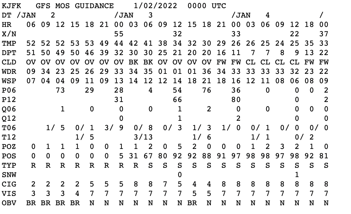
00Z MOS for JFK and LaGuardia Airports in NYC. Light snow indicated..

-
1
-
-
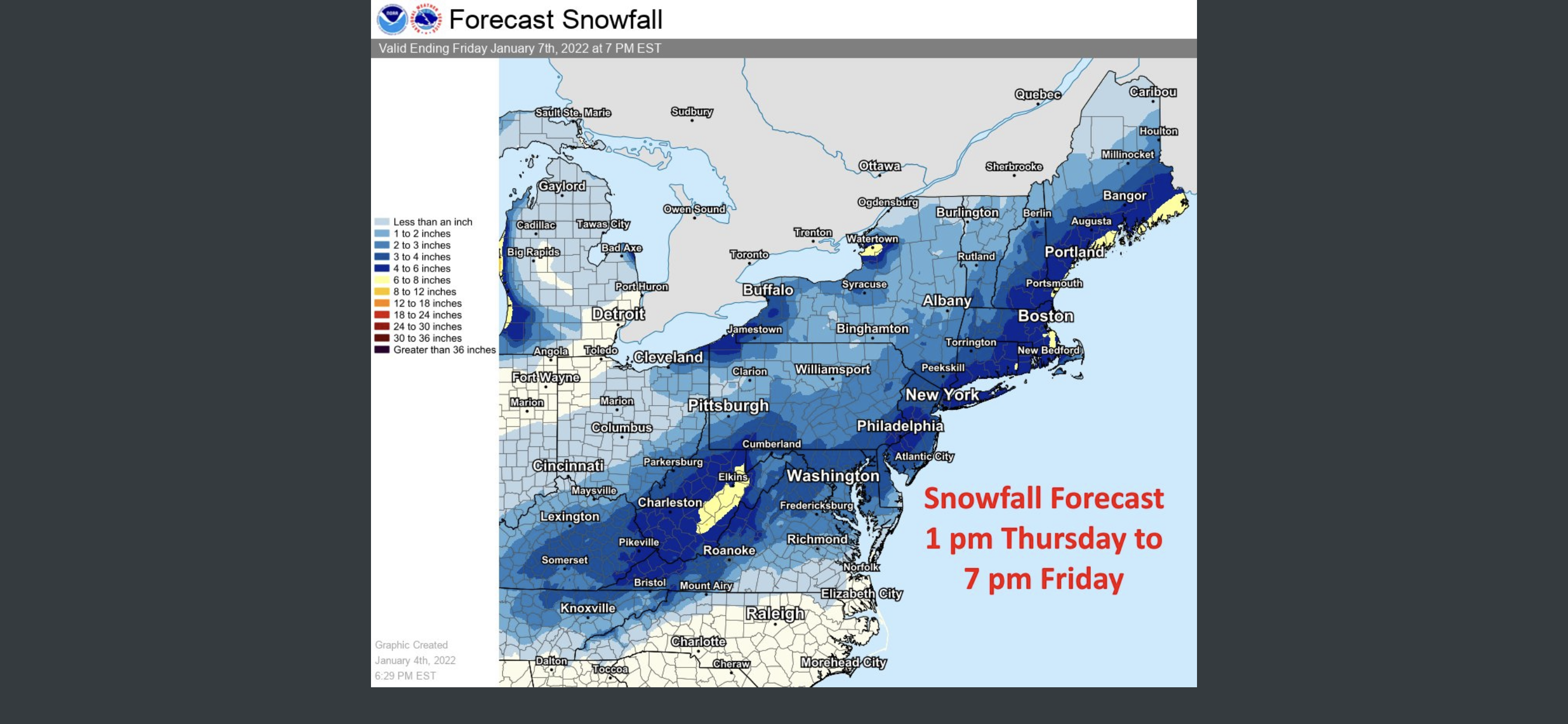
Earlier NWS NYC Forecast Discussion:

"This will overall be a minor light snow event. Snowfall totals
are expected to be greatest over eastern Long Island, where 1-2
inches are possible. Farther west over northeastern NJ and NYC
up to an inch is possible. Snow totals drop off farther north,
with the CT coast and southern portions of the Lower Hudson
Valley likely seeing less than an inch and far northern
locations staying dry. Trends in track will need to be monitored
given the nature of the tight gradient in QPF and snowfall.

Timing of the event may be the biggest concern. Snow starts in the
early morning hours on Monday and will continue through the evening.
This could impact the morning commute and potentially the evening
commute for eastern Long Island. With temperatures dropping quickly
overnight tonight to below freezing, snow is expected to stick right
away. Given the uncertainty that surrounds this system, and current
light snowfall totals, have decided to hold off on any headlines
over our area in collaboration with neighboring offices. Subsequent
shifts will have to monitor new guidance and a Winter Weather
Advisory may be possible for eastern Long Island.."


Snow Friday 1/19/24: is it a period of light snow (less than 2"), or is there a chance of a 5" swath in part of the NYC subforum? Event OBS.
in New York City Metro
Posted