.jpg.82995912781a8a839ab578c3b293f48f.jpg)

weatherbo
-
Posts
6,507 -
Joined
About weatherbo

-
Mid/upper 50s with winds gusting upwards of 30 mph at times with some lake/terrain enhanced showers. Refreshing after the heat and smoke. AQI is 12 this afternoon.
-
Had two severe warned storms today. Rain totaled 1.78", with some small hail and gusty winds with each one. Garden took a bit of a hit but nothing a stake and some rope didn't fix. Weather the next couple days looks cool, high in the 60's tomorrow with a low in the 40's. AQI of 101 should improve further tomorrow.
-
Conditions up here have improved quite a bit since yesterday. AQI in Mqt is 176 with rain showers moving in. Probably not out of the woods with the smoke tho.
-
My sister was flying in today from Florida to MQT and her connecting flight from Chicago to MQT has been cancelled due to visibility and ash. I've never seen smoke this bad at the surface before.
-
Just a coating, I'm sure they're aware. It's all over social media.
-
Enough that you can blow a flat surface is see the ash blow away, and its visible falling too.
-
Accumulating ash
-
Just went outside and the smoke smell is thick and there's a coating of fine ash on everything.
-
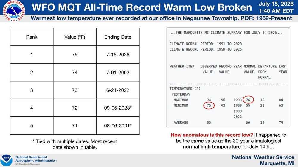
The all-time warmest low temperature was set at our office today in Negaunee Township at 76°F. This breaks the previous record warm low of 74°F set in July of 2002. Records for our office date back to 1959 with an observational period of midnight to midnight EST (1 AM to 1 AM EDT). What makes this record exceptional is that it happens to be the same value as the 30-year normal high temperature for this time of year.
-
96 with more humidity than yesterday. Glad it's over. Upper 70's-low 80's the rest of the week. Cue the smoke.
-
Reached 98 here. Dews fell from the mid 70's to the upper 50's during the hottest part of the day, so it wasn't that bad. Highest reading in the UP was 102 @ Baraga Plains. They're usually one of the top 5 cold spots too. One more day in the mid 90's, then back to more respectable summer weather.
-
90/75 and as still as can be.
-
Yeah, sure! Whether it's 97 or 100 it's going to be crazy hot, might as well set a record. I'm pretty much down for any extreme type of weather. I have frozen watermelon and ice water for the chickens, and frozen baby carrots for my bunnies to munch on. Hopefully that will keep them from getting too hot this afternoon.
-
The NBM shows WFO MQT reaching 99 degrees, which would place today in a 4-way tie for the all-time record (period of record since 1961). If downsloping can get the shoreline to 100 degrees, it will be only the 27th time 100 degrees has been recorded in the City of Marquette since the 1860s (including times with less reliable instrumentation and siting). The Ironwood WWTP site has not recorded a 100 degree temperature since the 1940s, while the Iron Mountain WWTP site has only reached 100 3 times since the 1940s (the IMT ASOS has never recorded 100 degrees F since it was installed in 1996). All of this to say, the level of heat today will likely (50+%) be on the level that most Yoopers would have to leave the UP to experience in their lifetimes. Overnight lows tonight only look to fall to the low to mid 70s, providing little relief for those without air conditioning.
-
High of 84, well below the 92 forecasted. Had a severe warned storm move through that did not produce severe conditions but did drop .74" of much needed rain. Point up to 99 tomorrow. Gonna be brutal... currently 73.


