

Entry posted by Ellinwood ·
4,201 views
So here we are with another complicated setup and poor model agreement leading to a low confidence forecast. The good news is it looks like DC is finally going to get a decent storm! It only took until March...
Anyway, right now it looks like the biggest risks are along the coast and in PA and southern VA. I'll save some of the more intricate details for the final forecast, but there is going to be some serious issues with the rain/snow line in the lower-total areas to the south, with precip. shield concerns across PA, NJ and southern NY.
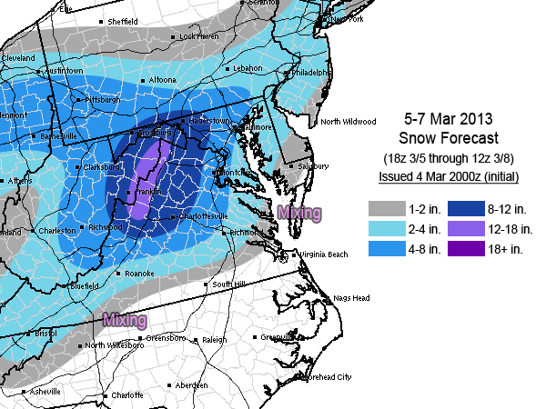
There is also some upside risk west and a little north of DC, where strong banding will likely occur somewhere in there. The other big question is with the coastal low track and whether or not the more northerly GFS and bring higher snow totals to PA/NJ northward or if the more conservative Euro wins out in those areas. In that case, I decided to lean a bit more towards the Euro with the lower totals.
Some strong, gusty winds are possible east of the mountains north of the VA/NC border.
EDIT: Somehow an old forecast got uploaded. Fixed now.
0 Comments
Recommended Comments
There are no comments to display.
Create an account or sign in to comment
You need to be a member in order to leave a comment
Create an account
Sign up for a new account in our community. It's easy!
Register a new accountSign in
Already have an account? Sign in here.
Sign In Now