
Supercells in Massachusetts Aug. 4

Entry posted by Quincy ·
4,029 views
 A series of supercell thunderstorms moved through central and eastern Massachusetts this afternoon. Some of the storms prompted tornado warnings and there were multiple significant severe weather reports as a result. Some of the thunderstorms originated as far west as eastern New York and later reached peak intensity as they moved into portions of central and southern New England. Even the coastal community of Boston was hit with some regionally impressive severe weather.
The prelude to these afternoon storms actually came in the form of early-day severe storms this morning. A line of severe wind-producing thunderstorms affected portions of southeastern Connecticut, Rhode Island and Cape Cod. An area that does not often see severe weather, especially during the morning hours. Once those storms moved out, there was some clearing, which led to plenty of daytime heating to fuel another round of thunderstorms.
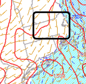
By early afternoon, there was an area of moderate to strong instability developing across the eastern half of Massachusetts, coinciding with seasonably strong wind shear. The mesoanalysis showed a corridor of moderate buoyancy coinciding with more than adequate wind shear for supercell thunderstorms. Bulk wind shear was in excess of 50 knots across the region. With clusters of thunderstorms ongoing across portions of the area, the storm mode was going to be critical in the evolution of the event. If storms merged, lines would form, suggesting more of a damaging wind threat. If the storm mode was messy, the inflow region and overall environment could be disrupted, resulting in mainly sub-severe storms. However, if any storm could remain discrete and from on the southeastern fringe of the activity, in order to take better advantage of stronger instability, then things would become a bit more interesting.
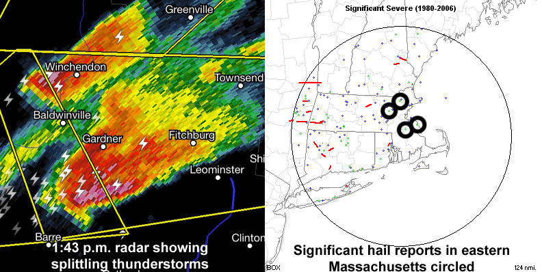
Two thunderstorms began to split in northern Worcester County shortly before 2 p.m. The northern most storm tracked east-northeast into far southern New Hampshire. This storm merged with surrounding storms and did not strengthen much. The southern storm took a bit of a right turn and continued in a generally eastward direction. This cell moved through northern Worcester County, organizing quickly into a robust supercell. Velocity and hail signatures increased, indicating the likelihood of 1-2″ diameter hail. This storm further organized with rotation becoming more focused. A hook was noted on radar and a Tornado Warning was issued. The storm continued into northern Middlesex County, dropping more large to significant hail, but the velocity signature was marginal at best for tornadic development. The main story was hail.
Speaking of hail, a second supercell developed on in west-central Worcester County a short time later. This storm was semi-discrete, but remained that way for quite some time. It also dropped large hail and continued for two more hours, moving right through downtown Boston. Large hail was reported throughout portions of the city and surrounding areas. Overall, there were numerous reports of golf ball or larger hail across Massachusetts, with at least three confirmed reports of hail at least two inches in diameter. A few additional discrete storms developed later in the afternoon, but earlier storms had overturned the atmosphere a bit. These storms were generally strong to only marginally severe in nature.
No tornadoes have been confirmed as of 10:00 p.m. Although there was some localized backing of low-level wind fields, the lack of favorable low level helicity was a limiting factor in the tornado potential. Nonetheless, a fairly uncommon significant hail event affected the eastern half Massachusetts, an area that based on a 1980-2006 average, only reports significant hail once every 6.75 years. This is based on four reports across all of eastern Massachusetts, during the time. While there were four significant hail reports in that 27 year span, there were three such reports this afternoon alone. Keep in mind that the time of record is relatively short, as reports from 2007 to this year were also not included.
A look at the 2 p.m. mesoanalysis showing 1000-1500+ J/kg MLCAPE and locally backed near-surface winds in the vicinity of the most robust supercells:
0 Comments
Recommended Comments
There are no comments to display.
Create an account or sign in to comment
You need to be a member in order to leave a comment
Create an account
Sign up for a new account in our community. It's easy!
Register a new accountSign in
Already have an account? Sign in here.
Sign In Now