
Severe Weather Sunday

Entry posted by Quincy ·
3,711 views
 Severe thunderstorms are likely today across portions of the Plains and Mississippi River Valley.
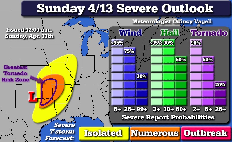
Ongoing thunderstorms early this morning may be marginally severe across portions of Iowa, northern Missouri and Illinois. Additional showers and thunderstorms are likely from late morning into the early afternoon hours further south before a more serious threat develops.
Sunday afternoon, low pressure will be in the vicinity of the central border between Texas and Oklahoma. An upper level shortwave will begin to rotate through the area with a vortmax swinging into eastern Oklahoma. Thunderstorms will likely fire just ahead of a dryline during the afternoon hours. These thunderstorms can explosively develop, producing large hail, damaging winds and at least a few tornadoes.
The greatest potential for tornadoes will be from extreme northeast Texas into eastern Oklahoma. There is some uncertainty with respect to how far north this threat will extend, but the area south of the KS/OK/MO tri-state border has the highest probability of seeing tornadoes. There is high confidence that there will be numerous severe reports, but it is not clear over how large of an area the most intense storms will extend.
Climatology suggests that the tornado threat could extend further east into Arkansas and southern Missouri late Sunday night into early Monday. Although this is possible, a loss of heating and a cold front overtaking the dryline should mitigate the risk after 12 a.m. Monday.
0 Comments
Recommended Comments
There are no comments to display.
Create an account or sign in to comment
You need to be a member in order to leave a comment
Create an account
Sign up for a new account in our community. It's easy!
Register a new accountSign in
Already have an account? Sign in here.
Sign In Now