
Severe Weather Possible This Weekend

Entry posted by Quincy ·
26,389 views
 The potential exists for a low-end severe weather outbreak across portions of the Plains this weekend, April 12th-13th.
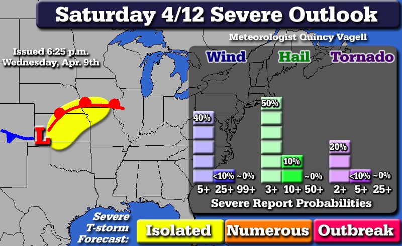
The first focus is on Saturday afternoon into the overnight period across the central Plains. Surface low pressure is forecast to move to a position in the vicinity of the Oklahoma panhandle by 00z Sunday. Now while there is good agreement among the models of destablization in the warm sector, capping will likely mitigate any convective activity for most of the day. However, by late afternoon and into the evening hours enough of the CAP may erode to allow for some isolated severe thunderstorms.
In the upper levels, a broad positively-tilted trough is projected to be crossing the Rockies late Saturday. The NAM and GFS show an embedded, but small vortmax being ejected northeast from Kansas toward the Missouri/Iowa border Saturday night. Wind fields are not overly impressive and the 18z NAM low level jet appears overdone. With that said, at least 30 knots of bulk wind shear is modeled.
CAPE values via the NAM and GFS exceed 2000 J/kg from Oklahoma up into Kansas and northern Missouri. The Euro has increased instability somewhat from the 00z run, but only maxes out values around 2000 in eastern Kansas. Given the amount of CIN that has to be overcome, the severe potential here is marginal at best. Given the time-frame three days out, the exact positioning and severity of this threat could shift.
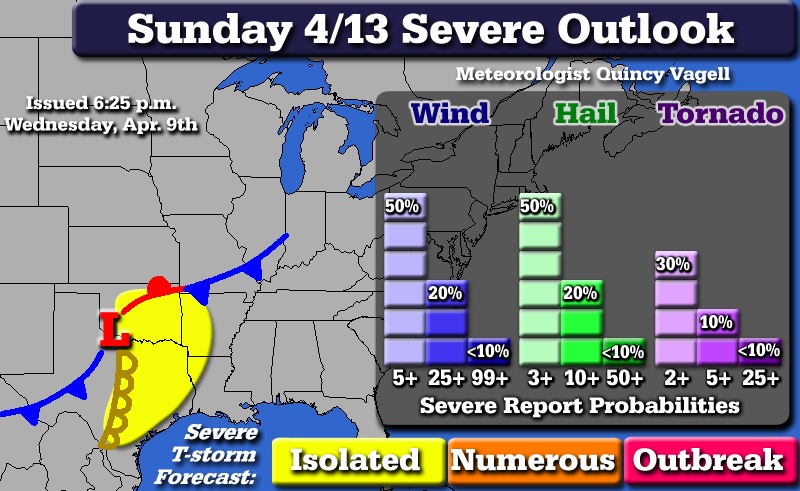
A somewhat more favorable severe setup may develop on Sunday. As the upper level trough digs into the southern Plains, surface low pressure deepens and slides southeast through Oklahoma and into northern Texas. With the trough axis approaching a neutral tilt, the overall dynamics alone become supportive for severe thunderstorms.
At the surface, low pressure matures across far northern Texas Sunday afternoon as a strong cold front quickly dives south. A moist southerly flow will aid with moisture transport as dew-points move into the mid and upper 60s. The GFS also shows lifted indicies as low as -12. Ahead of the dryline, a moderately unstable air-mass is forecast on both the GFS and Euro. The GFS has 1500-2500 J/kg of CAPE across eastern portions of Texas into southern Oklahoma with the Euro showing similar instability levels. There should not be much capping, so convective can initiate ahead of the dryline with isolated supercells possible in the warm sector as well.
Kinematic support increases with bulk shear in excess of 50 knots possible further south of the low across Texas. While damaging winds and hail may be the most significant threats, the setup may also be supportive of at least a few tornadoes. Severe thunderstorms could continue into early Monday, with at that point the cold front should have overtaken the dryline. The result would be more of a squall line with potentially damaging winds than discrete supercell structures. If the somewhat faster GFS is correct, the threat would extend further east into Arkansas and Louisiana.
While confidence is greater in the severe threat on Sunday, a faster-moving cold front or weaker storm system could alter the forecast. There is relatively narrow window during the second half of Sunday that this system must align with in order for severe weather to be a significant concern. A quick note that the 18z GFS has trended toward stronger kinematic support for Sunday.
1 Comment
Recommended Comments
Create an account or sign in to comment
You need to be a member in order to leave a comment
Create an account
Sign up for a new account in our community. It's easy!
Register a new accountSign in
Already have an account? Sign in here.
Sign In Now