
April Outlook - Central/Eastern U.S.

Entry posted by Quincy ·
6,005 views
 A colder than average pattern may persist into April across the Great Lakes and Northeast.
Based on the information I've been reviewing over the past several days, I have enough confidence to post a temperature outlook for the month of April.
As I see it, below average temperatures will likely continue from the Great Lakes into interior New England and up toward Hudson Bay Canada. I expect a continuation of troughiness extending from southeast Canada into portions of the Northeast. While the heart of the Arctic air should remain well north of the U.S. border, there are other factors coming into play. With the current Great Lake ice coverage being significantly above average, it is going to take quite some time for the ice to melt and for lake-water temperatures to rebound. This means that any wind flow over the lakes will likely bring at least locally cooler temperatures, with transport from cold water to the adjacent land.
For portions of the Deep South and especially into the southern Plains, I am expecting slightly above to moderately above average temperatures. A gradual re-emergence of a "Southeast Ridge" combined with a general storm track (with shifting entirely possible) through the Ohio Valley and Northeast, warmer air should be able to extend from the lower Mississippi Valley toward the lower Appalachians. Further west, the long-term drought over the central and southern Plains may persist, which is return would tend to allow for higher daytime temperatures than what is observed on average. Temperatures along the immediate Gulf Coast may be able to remain near average, as sea-surface temperatures in the area are running somewhat below average.
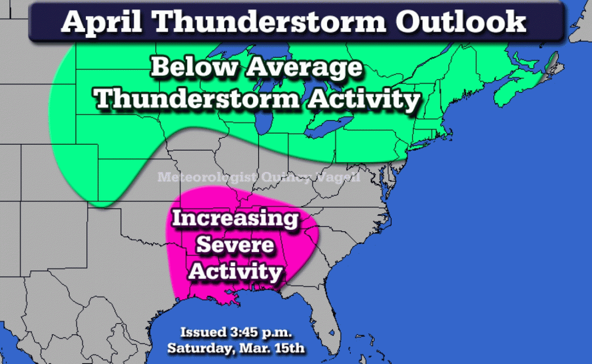
Further speculation into the potential severe weather season leads me to believe that a relatively slow start to the season will continue. With that said, I can see a scenario where the region from the Ark-latex into Mississippi and Alabama has the opportunity for at least a few severe weather outbreaks into the month of April. This is supported by climatology as well, but places such as Kansas, Oklahoma and western Texas may not see a marked increase in severe weather activity until the second half of April. Severe weather forecasting is challenging, because all it takes is one major event to leave a mark. 2013 is a great example, as while the overall year saw below average severe storm reports, there were at least a few particularly damaging events.
Other supporting references:
- The Euro weeklies and now the extended day Euro ensembles show the Northeastern U.S. trough relaxing north with some ridging (above average temperatures) across the Gulf States. (this is for the final days of March leading into the start of April)
- The CFS up until late last week had a strong lean on well below average temperatures continuing across the Northeast. There has not been the greatest run-to-run continuity, but as of March 18th, there was at least moderate agreement with warming by the 2nd week of April.
- The extended CMC ensembles do show some troughing in the East to start April, despite substantially above average heights in the final days of March in the same area.
- The MJO is forecast by the Euro ensembles to move into Phase 2 and perhaps even Phase 3. The GFS ensembles move the MJO toward the edge of Phases 8 and 1, with the end of the curve clustering into Phase 1. More lean is placed on the Euro solution, however it should be noted that Phase 1 of the MJO favors below average temperatures in the eastern U.S., especially the Great Lakes. Phase 8 is closer to neutral/average. Phases 2 and 3 both match up more closely to Phase 1, with below average temperatures in the East and well below average temperatures from the Great Lakes into New England and southeastern Canada.
- The 1993-94 seasonal analog has matched up in more ways than not to 2013-14. April 1994 saw a return to near and slightly above average temperatures in the East, with some stations reporting well above average temperatures in the Deep South and southern Plains.
- March 1967 has several days that match up closely to the predictions for the latter half of March 2014. April 1967 featured considerably warmer than average temperatures across the southern Plains.
With all of the factors considered, I think this is a fair forecast to make at this point. Since we're talking about temperatures averaged out for the entire month of April, it's possible that an overall colder than average pattern lingers into the beginning of April before shifting. It is likely that even in such a pattern, we could see a couple of bouts of warmth. A good example is at the end of March. While as of March 18th there was a strong signal for an East Coast low around March 25th-26th, the consensus at this point is that some above average temperatures reach the Northeast once the low passes.
On Saturday, I said this:
"Such a setup could yield a late-season winter storm somewhere in the Northeast between March 25 to April 5, but that remains to be seen."
There is a growing signal of a late-season winter event from March 25-26. However, given the overall troughy pattern expected to start April, there could be yet another winter event between April 1-5.
I contemplated putting together a precipitation forecast, but rain/snowfall can vary substantially over a region, especially this time of the year. I think the pattern will remain active and perhaps some of this activity could help relax the drought in the Plains come later this spring.
This was outlook was originally created on Saturday, March 15th, but I have added a few things here and there as new data as arrived. The maps and overall thinking have not changed. This is my first stab at a formal long-range forecast, so a lot will be learned by watching how the trends pan out.
0 Comments
Recommended Comments
There are no comments to display.
Create an account or sign in to comment
You need to be a member in order to leave a comment
Create an account
Sign up for a new account in our community. It's easy!
Register a new accountSign in
Already have an account? Sign in here.
Sign In Now