
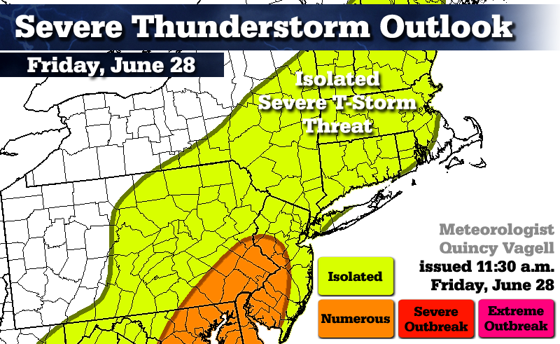
Severe WX Outlook Friday, June 28th: Northeast/mid-Atl.

Entry posted by Quincy ·
8,477 views
 An upper level trough across the Great Lakes is associated with areas of surface low pressure in and around New York State. Bands of showers and thunderstorms have been pinwheeling through the eastern United States as a result. By afternoon, more organized thunderstorm development is expected and some storms could become severe.
Isolated severe thunderstorm threat...
Low pressure is spinning across New York State. An area of increased wind shear is in place along the east of the Appalachians. Satellite imagery has indicated that much of the region has broken out to at least partial sunshine. This is creating moderately steep lapse rates and with cooler temperatures aloft associated with a 500mb trough, that steepness continues into the mid-levels. A rich southerly flow continues to keep dew-points on the higher side with most stations in the upper 60's to lower 60's.
As far as forcing goes, there there is a weak frontal boundary movingly slowly eastward across the Appalachians. The higher resolution models couple that disturbance with an unstable air-mass and develop isolated thunderstorms and broken line segments across the Northeast by mid-afternoon.
Some of the obstacles include a marine influence and some shower activity across southern New England, which may limit just how much the atmosphere can destabilize. However, elevated amounts of wind shear can promote updraft formation and some strong to severe thunderstorms. The coverage of these storms is not anticipated to be widespread in New York and New England. With cooler 500mb temperatures, there is a marginal hail threat with some of the stronger updrafts. Damaging winds seems to be the biggest concern with a relatively low, but still mention-able tornado threat, especially given the relatively low ML LCL's. Climo would not favor widespread severe activity given a south wind, but a coastal front could have some interaction with the upper level setup, which may slightly enhance convective activity.
Convection is trying to initiate as of midday, but the focus is from early to mid afternoon across the Appalachians and late afternoon in southern New England for any strong to potentially severe storms.
Numerous severe thunderstorm threat...
Further south, stronger wind shear combines with more impressive daytime heating to warrant a threat of numerous strong to severe thunderstorms. The focus for this extends from southeastern Pennsylvania and western New Jersey and points southwest. Here there is a threat of large hail, damaging winds and also isolated tornadoes, especially given bulk shear values near or possibly above 50kts this afternoon.
0 Comments
Recommended Comments
There are no comments to display.
Create an account or sign in to comment
You need to be a member in order to leave a comment
Create an account
Sign up for a new account in our community. It's easy!
Register a new accountSign in
Already have an account? Sign in here.
Sign In Now