
KEITH L.I
-
Posts
2,235 -
Joined
-
Last visited
Content Type
Profiles
Blogs
Forums
American Weather
Media Demo
Store
Gallery
Posts posted by KEITH L.I
-
-
3 minutes ago, winterwx21 said:
As SACRUS said, the warmup mid next week looks significant. At least mid 70s wednesday and thursday. The cooldowns, like the ones coming for this sunday/monday and next weekend into early the following week, aren't very impressive with high temps still making it to the low-mid 60s.
I think the cooldown next weekend will be significant.High won't get out of the 50's which is slightly cooler than normal.Again folks it's the Fall. Winter doesn't arrive for over 2 months. Enjoy this nice weather
-
 1
1
-
-
9 hours ago, CoastalWx said:
It typically is a -PNA which usually is lower than normal heights from AK into the Rockies. El Niño is the opposite. Because of our latitude we can do fairly well in Nina’s, especially if the dateline ridging is more poleward. Sometimes you can get real lucky and get a period of blocking to really make it snowy and turn those lows that would cut, into either SWFEs or Miller Bs that redevelop under SNE. You also can play with fire in that pattern if the troughing out west is really deep and/or a raging +NAO. 07-08 was probably the one winter where the NAO was so positive, it set up confluence to our northeast and forced would be cutters to redevelop more towards the cape and SE MA.
In general, SNE does better when the ENSO phases are on the weaker side. You generally don’t want strong Nino or Nina.
It's usually not always..66-67,95-96 and 10-11 featured a trough in the east and were historic snowy winters for the Northeast..They were La Nina's
-
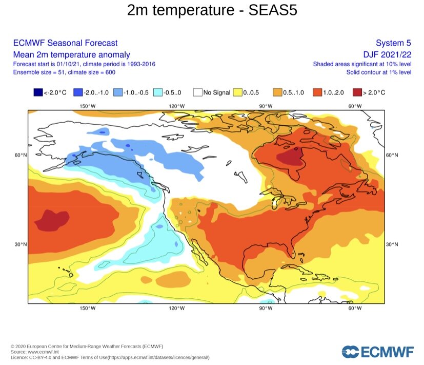
40 minutes ago, bluewave said:
It will all come down to how much blocking we get. Unfortunately, the seasonal models have very little skill at forecasting the correct phase of the AO and NAO. When the ENSO is coupled, they do much better with the North Pacific pattern.
Darker oranges more skill

Since 2010, the stronger La Ninas had more snow. During other periods, the weaker years had more snow. So there may not be much correlation between snowfall and La Niña strength. It really comes down to how much blocking we get
Cold phase years have had some great winters...66-67,95-96, 10-11 and some horrible ones..It's all about blocking. The one thing that is certain..strong el nino's are most part very warm, but that doesn't mean you can't get a big snowfall..Feb 83 and Jan 16. It's all timing. Also looking at the monthly's and seasonal forecasts take them with a grain of salt
-
 1
1
-
-
33 minutes ago, winterwx21 said:
Apple picking is a nice activity. Have a great birthday! My birthday is next week as well, on tuesday.
October 19th..63 years old..Happy Birthday!
-
1
-
-
33 minutes ago, donsutherland1 said:
It’s definitely not what winter weather lovers would like to see.
Looks like last year. Seasonals are not very accuarate.I mean it could turn out that way but predicting weather a month or 2 or 3 months in advace is basically a toss up. I remember saying this around this time last year when we were all on suicide watch because of the monthly's.
-
6
-
-
31 minutes ago, LibertyBell said:
The La Nina and PDO have finally bound together.
I actually thought this year would be a neutral cold winter, so either way I wasn't expecting much snow since neutrals after La Nina tend to be among our least snowiest.
Again and I say this before every La Nina winter,if there is blocking in the Atlantic it could be a decent winter. If there is no blocking expect a warm winter.Last year there was blocking, the pacific was horrible but we were above average snow.. La NIna winters are also front loaded so a cold December is usually the case
-
28 minutes ago, SnowGoose69 said:
There are not too many cases where the Oct pattern continued through the winter. I always tell people on the dumb basic meteorology scale if you can be mild from 10/1-11/15 its way better than being -5 for that same period if you want a cold and snowy winter. 2000 is one of the few cases in the last 25 years where the October pattern more or less continued all winter
76-77 had straight cold from October through February, however February moderated and March was warm
-
2 hours ago, SACRUS said:
We will push 80 in the warmer spots Sat, if enough sun on Sunday (10/3) it will be low 80s (EWR record is 85). More clouds and Mon (10/4) as upper low pushes west and hung up flow overall. Should see more persistent onshore to more humid S/SE flow by the middle/end of next week Thu (10/7) - Sat (10/9). Beyond there ridge builds into the east and warmer mid month. Not sure we see more 80s in the period 10/10 - 10/20 in the warm spots but chances may be increasing.
Very La NIna October, at least for the first part with the SE Ridge. Euro monthly's had a warm September and October followed by cooling in November and a cold December. Hope that pans out
-
1
-
-
9 minutes ago, psv88 said:
Subtropical day here…80/73…on September 23
Your on the wrong side of the cold front
-
1
-
-
Front passed in Central PA..62 degrees and sun..Yes it is Fall!!.Have to wear a jacket..beautiful!
-
3
-
-
When to the lanternflies go away?..Hopefully the first frost. Hate those bugs!
-
1 hour ago, donsutherland1 said:
That was the kind of extreme event that probably won’t recur for at least a few years.
Warmer than normal temps in October are 70's and some low 80's. A way above normal day you might approach 90, however they are rare
-
2
-
-
This page will take us from the last days of heat. To the crisp days and nights of fall. Football season, World Series, Halloween and into the holiday season, and the first snowfall for some. Favorite time of year
-
7
-
-
5 minutes ago, Itstrainingtime said:
Good grief is it pouring here now. Winds are picking up as well.
Heaviest of the day so far
-
Just now, Bubbler86 said:
Holy Moly. Where at on 283? Close to MDT or LNS?
Don't know somebody posted it of FB
-
-
Flash flood warning alert just came over my cell
-
1
-
-
20 minutes ago, SACRUS said:
Sep to open wet with remnants of Ida 2- 4 inches od rain, then a dry cooler weekend 9/3 - 9/6 near 80 each day and perhaps low 80s by labor day (9/6). Next week we watch another front potentially get hung up before warmer air arrives with rising heights into the east later next week 9/10.
Looks like we are finished with the heatwaves. Not saying it could not hit 90..although most models don't show any through the middle of the month..But typical September weather takes over with 70's and the warmest low 80's
-
36 minutes ago, Superstorm said:
Yeah, not much rain expected further north so Susquehanna should be ok.
Creeks and streams will have major issues.
.How much rain did this area have with Agnes in 1972?..I know the Susquehanna had major problems with flooding
-
1 hour ago, paweather said:
In the Top 5:

Combined with high dews it's been a sizzler..Was waiting for my Long Island seabreeze lol..not in these parts. Also seems like this area has higher humidity and more pop up thunderstorms..Love the area anyway
-
1
-
-
1 hour ago, Mount Joy Snowman said:
Good to have you aboard sir! Always nice to have other western Lancaster County folk.
Thanks
-
1 hour ago, Itstrainingtime said:
To me, the plus 8 for September idea is going to come down to dewpoints. Average lows really start falling in September, if we have higher dews we'll have warm nights and that would get us there.
8+ September?..wow..most of the days would be in the 80's or 90's with lows near 70..Never happen..Usually warm Septembers are +2 to 3 range..Every September features cool downs when lows dip into the 50's..sometime 40's
-
1 minute ago, Itstrainingtime said:
Welcome Keith! Good to have you new to our area (Elizabethtown) after coming from the Island.
Thanks..great to be here
-
2
-
-
Personally I think we suffer with the heat and humidity this week..Get a bit of a break over the weekend and go back to near 90 early next week..Looks like afterwards the back of summer is broken as we kick off September. It will still be warm somedays but I think this is our last prolonged heatwave for 2021
-
1
-


October 2021
in New York City Metro
Posted
Average high is 63..so normal gets you into the low 60's. 10 degrees above normal gets you into the low 70's..10 degrees below low 50's..It's October