
KEITH L.I
-
Posts
2,235 -
Joined
-
Last visited
Content Type
Profiles
Blogs
Forums
American Weather
Media Demo
Store
Gallery
Posts posted by KEITH L.I
-
-
6 hours ago, bluewave said:
Models were lucky to get the forecast right a day or two in advance during the 70s and 80s. Then the Euro did really well with the March 1993 storm of the century and January 1996 blizzard.
Sometimes the Euro seasonal can do well with a 3 month forecast like it did last summer. But winter seasonal forecasts have much less skill. Probably too difficult to get the state of the polar vortex and MJO correct very far in advance.
AI may need to be added to the models to have a chance at pushing beyond the 2 week limit.
I was around in the 60's where heavy snow warnings became partly cloudy the next day.Two to three day forecasts was a reach back then like monthly or seasonal forecasts are now.
-
5 hours ago, bluewave said:
It’’s going to be a while before we get record heat again like we had yesterday. The whole pattern is shifting right as we start June. May featured consistent onshore flow and short periods record heat only lasting a day or two. The record ridge over the Northeast and Great Lakes is getting replaced by a trough.
May pattern
Much different pattern into mid-June


CFS now has a cool July too.Has Euro backed off yet from their hot Summer forecast?
-
 1
1
-
 1
1
-
-
31 minutes ago, bluewave said:
A record breaking 7th warmer than average winter in a row for our area. The SE Ridge or WAR has been a dominant player since the historic December 2015 +13.3 departure. So the limited colder departures end up further west away from this persistent 500 mb height anomaly.


So a warm December, cold January, with a big snowstorm, blizzard for Long Island, slightly above normal February..Overall below average snowfall.We'll have to see if we can get near normal snowfall in March
-
1
-
-
winds are really intense in Elizabethtown..gusts had to be over 50 mph
-
1 hour ago, weathafella said:
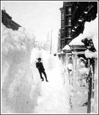
44 years since 78. Great story Steve. We all have disappointments in life and living in California and therefore missing 78 is among my biggest to take to the grave with me.
The greatest storm for Long Island and New England. I was 19 years old in Babylon Long Island. Parts of the Long Island Expressway was closed for 3 days. Drifts must have been 5 to 6 feet. Way above garage door. The most snow I have ever seen.
-
1
-
-
1 hour ago, snowman19 said:
Solar spring starts Tuesday (2/8) and ends (5/8), it’s the time of the most rapid gain of sunlight of the year. Solar summer starts on 5/8
Don't forget solar fall starts August 8th, but it sure can get very hot after that
-
2
-
 1
1
-
-
From Elizabethtown to Carlisle at 430 tomorrow morning, I'm wondering should I stay at a hotel in Carlisle or try to make it to work?
-
22 minutes ago, Wmsptwx said:
Welcome to central pa bro lol we do pull off great seasons though, I did last year…but expect home run balls to be few and far between.
I have lived here for 2 years. It seems like we are always in the middle of things..Too west or too east.
-
To tell you how crappy this winter is. I moved from Long Island, they are getting 1 to 2 feet of snow and I'm getting sunny snow showers lol
-
2 minutes ago, LibertyBell said:
I mean it helps when you've experienced several 20 inch storms like we have. Anything we ever get from now until we die is gravy. I honestly dont care if it ever snows again, because we've experienced the best and worst winter has to offer.
When you get in your 50's and 60's, snow all of a sudden becomes cold and messy. It's part of nature and the aging process I guess
-
2
-
-
1 minute ago, MJO812 said:
I have no clue what to think about these runs. These shifts are really drastic.
Mid Atlantic states get more snow than the northeast on this Nam run
If you take this so seriously it's a horrible hobby. It's just freakin frozen rain which looks white and 5 hours later turns into black and yellow slush and ice puddles.So glad I don't give a crap anymore. I just follow the tracking, that's fun..But the snow?..I can finally live without it. I'm free!
-
1
-
3
-
-
2 minutes ago, NorthShoreWx said:
Need a snowstorm on January 3? Here ya go:
Heavy snow and temps in the single digits
-
2
-
-
28 minutes ago, bluewave said:
I wouldn’t call it that.
") But their have been a number of posts getting weenied over the last month for just posting model data. Now I can understand if the charts were long range GFS OP snowfall maps. But most of the posts were just 500 mb height anomaly maps discussing teleconnections. We need to take emotions out of long range model discussions.
But their have been a number of posts getting weenied over the last month for just posting model data. Now I can understand if the charts were long range GFS OP snowfall maps. But most of the posts were just 500 mb height anomaly maps discussing teleconnections. We need to take emotions out of long range model discussions.
Most people here love snow. If it's not going to snow they get upset and depressed. You love all types of weather and post here even in the Spring and Summer.You just state facts.People might not like it because of their biases, but it is what it is.
-
1
-
1
-
-
Snowing moderate in Central PA ..about a half of inch everything is covered
-
1
-
-
1 hour ago, LibertyBell said:
thats why I see people predicting an el nino for next winter and not just an el nino but a strong one (see main forum)
As of now looks like a weak el Nino for next year. Anything beats this horrible pattern.
-
5 minutes ago, Great Snow 1717 said:
Amazes me how some individuals can completely ignore/downplay what has been happening for months but yet believe a change to a long lasting winter pattern is right around the corner.
Long lasting winter pattern in mid December?
-
3 minutes ago, CoastalWx said:
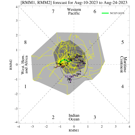
Well remember MJO phases won't always fit composites perfectly. It just gives you an idea.
Well phase 6 fit the last few weeks.Look at the temps this week
-
Just now, CoastalWx said:
It's not strong, but with that 500 look in the Pacific there will be a propensity for one I think.
Because of the -PNA I guess. I love seeing a -NAO because it usually leads to winter weather at this time of year. I'm not buying the Christmas warmup on Euro with a big block in Greenland and phase 7 of MJO. It should be much cooler.
-
4 minutes ago, CoastalWx said:
Later in the 11-15 day actually shows this. I know you don't want the SE ridge, but to me, that's a more active look with a cold source nearby. Maybe more SWFE or overrunning?
With -NAO, -AO in phase 7 of MJO, should there be a SE ridge?.Makes little sense to me
-
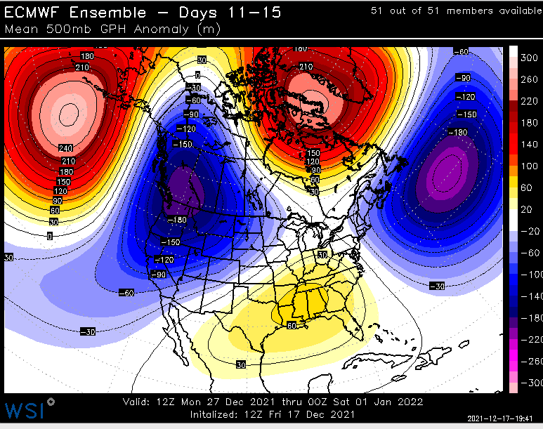
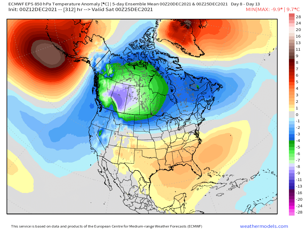
23 minutes ago, ORH_wxman said:
Here’s the 5 day 500mb anomaly mean ending 00z 12/25 and then the 850mb temp anomaly below that for the same time....we’ll have chances with that look but with the SE ridge, cutters are still a risk.


Ridge in Alaska,ridge in Greenland..does that 500 map make sense?
-
32 minutes ago, MJO812 said:
All the models have a storm lurking at 240 hours
Latest Euro

That's not really a bad look..or is it?
-
13 minutes ago, snowman19 said:
The new Euro just like the Ukie wants nothing at all to do with Tues/Wed. It’s a sheared out, disjointed mess of nothing
It gives a few inches, for early December, in this pattern, you'll take it.
-
1
-
-
17 minutes ago, snowman19 said:
View any model showing the MJO propagating into phases 7, 8, 1 with extreme skepticism
-
2
-
-
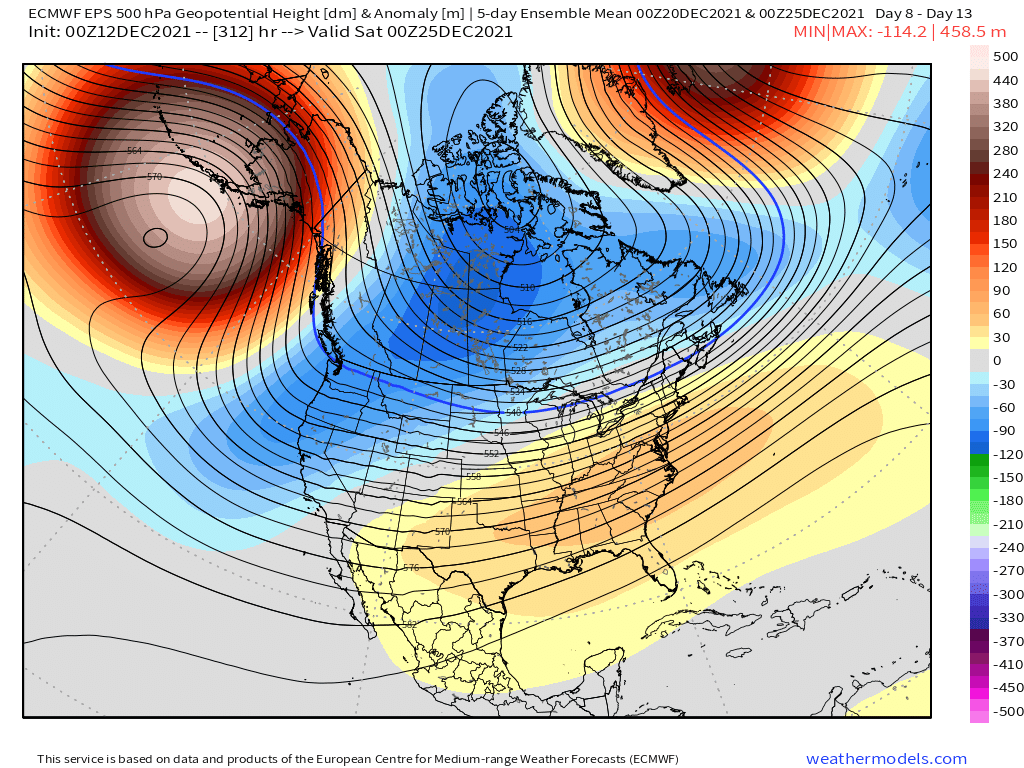
47 minutes ago, bluewave said:
It seems like the pattern forcing this near record -PDO is having a greater influence than just the La Niña alone. The -PDO is being driven by the extreme vortex in the Northeast Pacific. This caused a record +EPO in the fall. The vortex is next forecast to move to a very strong -PNA position. Unfortunately, this is combining with a very +AO pattern. The main question is what is forcing the -PDO instead of recent years with a more +PDO La Niña ?
All the guidance has -PNA +AO until further notice


MJO is in phase 7 by then..I think we might see a change around Xmas

-
2
-


June 2022
in New York City Metro
Posted
Only two models in the 70's..the LFM and PE..The PE went out 84 hours..That was long range back then lol