

Disco-lemonade
-
Posts
317 -
Joined
-
Last visited
Content Type
Profiles
Blogs
Forums
American Weather
Media Demo
Store
Gallery
Posts posted by Disco-lemonade
-
-
2 minutes ago, ncskywarn said:
Link is not working.
yea sorry crashed right when i posted try this one
http://surfchex.com/cams/carolina-beach-web-cam/
hopefully the oceanic's cam will be back on soon
-
Water level at wrightesville beach is getting higher, waves are looking pretty robust.
-
 1
1
-
-
17 minutes ago, ILM2714 said:
Welp, I’ll be riding this thing out in Wilmington which looks to get a pretty awful hit. I’m in a hotel which is built to withstand the hurricane but I hope I have something to come home to.
My girl friend just left and is coming to stay here, her grandparents are staying in wilmington, one of which is on an oxygen tank and has no generator. They refuse to leave, personally I am very fearful for their lives.
-
This may be the nuttiest gfs run I have ever seen
-
 1
1
-
-
2 minutes ago, shaggy said:
So last year Irma was as big and bad of a hurricane we had seen in many many years. Would the Florence threat be considered greater now? Cat 4 winds and surge over a much more populated area with exceptional rainfall and inland flooding.
Yea this is bad, and it's not like usual where we get a sheared out destabilized mess. This is something extraordinary
-
14 minutes ago, bigshaq00 said:
New to weather, so what could the triangle see from this storm. Could we see hurricane force winds or tropical force winds? Wind?
Please refer to the NHC forecast track cone
-
1 minute ago, JoshM said:
We're not out of the woods over here

You're right I've been so concerned about ILM that I haven't really given much consideration to MBY...
-
37 minutes ago, HKY_WX said:
Sorry bro, my wife and I love wrightsville beach, and this track wld ruin that beach. Tough to think about.
Agreed I'm down there every other week, so many great friends in the path of this, has me very worried.
-
 1
1
-
-
Just now, Brick Tamland said:
Keep hoping this turns and goes out to sea, or it never gets to a big hurricane. But this looks really bad for NC.
My concern is if this hits cat 4 people aren't going to know what to expect.
-
1
-
-
1 hour ago, SENC said:
I and DownEast,, Digress.. I'm sure He agree's I hope pulled he button on that genset.
I started mine.. got gas cans at the ready
..
I'll tell you, remember hurricane mathew a few years back? I was living in wilminton at the time, only a cat 1 (first hurricane I'd experienced), but when you see long leaf pines bending in ways they shouldnt over someones house, knowing they could snap at any moment will scare the bajeebus outta you. And the noise of it all I'll never forget... Then driving back through lumberton the amount of tree damage was surprising for how far in land they were. Straight line winds can maximize gust potential very quickly.
-
1
-
-
19 minutes ago, Brick Tamland said:
This is getting really scary. Hope she goes out to see, but looks like the tightest clusters from the model runs are between Charleston and Wilmington for landfall, and at least a cat 4 when it hits. This could be worse than Fran.
I agree, Florence may be the sum of all fears... I don't understand those dudes up in maryland rooting for it to go up the Chesapeake, makes me wonder, do they even get it?
-
1
-
-
5 minutes ago, the ghost of leroy said:
Diana 1984 looped and hollowed itself out...cat 4 down to kinda crappy cat 2 before landfall. #garbagehistory
Here, go ahead and see what kind of storm surge could be expected from a cat 2 on the outer banks and surrounding locations.
-
1
-
-
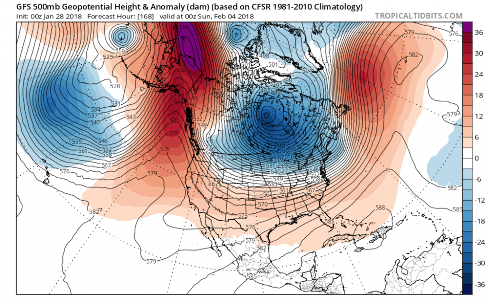
DT in a recent video mentioned how the setup is similar to isabel so i decided to bring up an upper air map for comparisons sake.
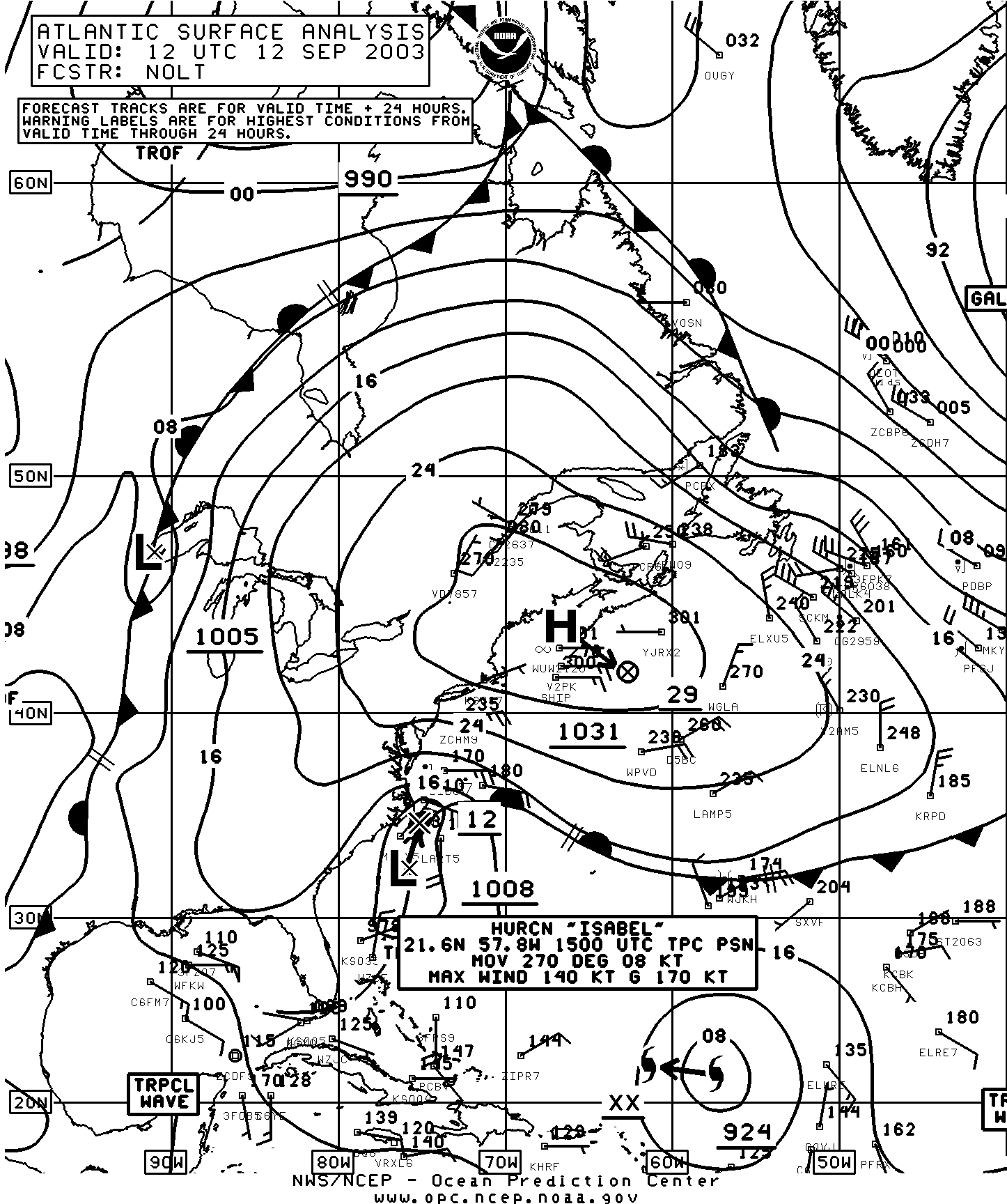
(hopefully it isnt a massive image)

Florence at roughly the same location on the GEFS ensembles, notice the high over the NE. That's what will likely block Florence from recurving early enough to recurve OTS without affecting land. Over the next few days we need to watch very closely how the models place that ridge. Personally I believe Florence will, at the very least, get close. I really hope the cool water and dry air prevents strengthening because OBX may experience hurricane force conditions.
-
21 hours ago, WinstonSalemArlington said:
The latest total snowfall accumulation in NC this season (so far).
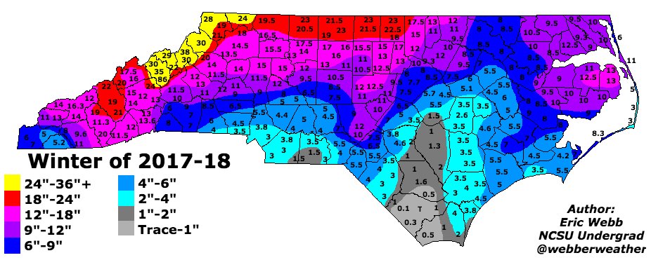
Yep definitely matches my numbers, can't complain considering 12 is twice our yearly average... but imagine what couldve been if feb hadnt sucked

-
47 minutes ago, Cold Rain said:
I'm with you guys on the LR models being shaky and so forth. But phrases like "models won't be able to see the LR well until ___________________" are usually what show up right before a warm pattern. I'm hopeful, that the SSW/AO/MJO/Bad Init/ETC are the flies in the model prog ointment. But it would be nice to see at least a MOVE in the direction of a colder pattern before the end of Feb.
agreed its impossible to say what we will be seeing at 144 hrs a week from now... last couple of weeks haven't been great but we've made it through plenty worse in the last 7 years
if we could just get a little nudge into phase 8 (still very possible) I'd bet someone within the climo favored regions of the SE will see a nice little closer to winter
the nao really is killing us but ensembles are hinting maybe we will see it go neutral as we get into mid feb, as we saw in early jan neutral is leaps and bounds better than raging positive
this would be supported by the mjo nearing phase 8
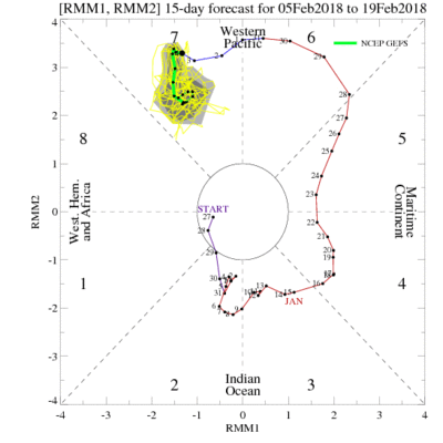
of course the modeling looks horrid right now, but when looking beyond 144 hrs remember verification scores
-
1
-
-
2 hours ago, Cold Rain said:
When are you coming to Raleigh? It’ll be plenty warm here. You can help me with some landscaping projects!

get ready for the pollen storms! I expect multiple "yellow outs" this year, perhaps even 200m:1 ratios
-
3
-
-
2 hours ago, isohume said:
The what?
-
models can hardly get 144 hr leads right!
climo climo climo...
march will save us!
-
1
-
-
for nc, need to see the gfs continue to loose the gl influence
the more high pressure we can get up there the better

-
this actually looks very promising. for rdu vast majority of gefs members track a low in a much more favorable position, more like the canadian

-
1
-
-
12 minutes ago, Queencitywx said:
Brick. No. The GFS was awful until 36 hours before.
gotta wait till we get into nam range, then the globals will all start playing catch up
-
2
-
-
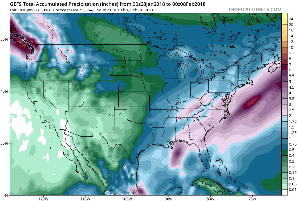
total precip out into fantasy and it looks good, max in the south (active) min in the northern midwest (arctic highs), I'd say at this juncture it looks like weve got a nice shot at some snow in the south before winter is over
")
however, that max west of the apps indicates plenty of runners in there so everybody cant always win
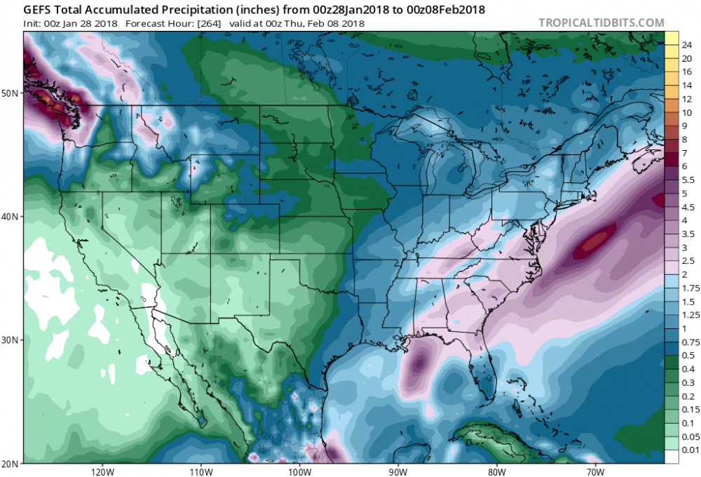
-
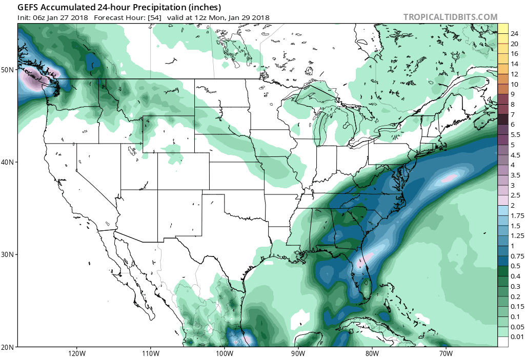
in short range news look at how the ensembles have increased totals on this weekends rain storm... some what of a theme this winter... most winters actually

-
6 minutes ago, mackerel_sky said:
A little blocking would make it perfect!
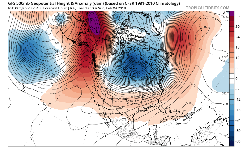
lets check the gfs block-o-scope 3000
well the pna and ao sure look great but dang that nao!
though we didnt have the nao on our side earlier in the month either
see the ensembles shortly
-
1
-
January Medium/Long Range Discussion
in Mid Atlantic
Posted