
Kaner587
-
Posts
2,639 -
Joined
-
Last visited
Content Type
Profiles
Blogs
Forums
American Weather
Media Demo
Store
Gallery
Posts posted by Kaner587
-
-
6 hours ago, LibertyBell said:
I wonder what the elevation is in this area? Northern location plus some elevation definitely plays a role in marginal setups plus there's sound enhancement too.
It ranges from 150-300 feet generally along either side of northern blvd. Where I am in laurel hollow elevation ranges 190-220. The peak elevation is actually in the west hills area with a max elevation of just under 400 feet
-
 1
1
-
-
4 minutes ago, SBUWX23 said:
If we had been in the 20s that would not have happened. It's impressive enough that we had the cooling we did without the nice high to our north.
Woke up at 3am and already had a coating. Knew we were in for 6+ after that. Seriously doubted it when I went to bed
-
4
-
 1
1
-
-
1 minute ago, SBUWX23 said:
The liquid equivalent out here was impressive in the 12-18z timeframe. Even here where it was 32-33, the temps and compaction were real. Probably would have had closer to 10 if not more but I'll settle with the half foot. Still a nice event.
The biggest issue I noticed was when rates slipped below 1.5/hr then compaction starting eating away at totals. In the period from 8am-10am and then again 1115-1pm totals rapidly increased but between 6-8am and 10-11;15 despite decent rates it barely kept up with compaction
-
3
-
 1
1
-
-
3 minutes ago, Kaner587 said:
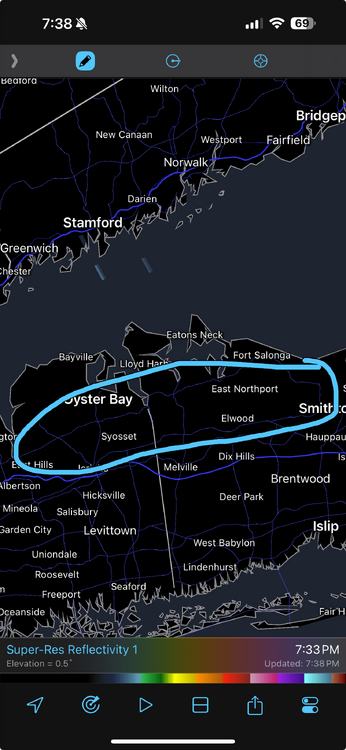
There’s a 8. 1 in glen cove 8.7 in locust valley 8.25 in dix hills further SE towards Jericho tpke, a 7.5 in north syosset 7.8 in muttontown 8 in commack and 7 in smith town. Paints a very clear picture that from about central Nassau between Jericho tpke and north of northern blvd there was likely a local max of 7-9 inches
-
4
-
-
3 minutes ago, donsutherland1 said:
I agree. The numbers out there appear realistic and in line with one another.
There’s a 8. 1 in glen cove 8.7 in locust valley 8.25 in dix hills further SE towards Jericho tpke, a 7.5 in north syosset 7.8 in muttontown 8 in commack and 7 in smith town. Paints a very clear picture that from about central Nassau between Jericho tpke and north of northern blvd there was likely a local max of 7-9 inches
-
6
-
-
1 hour ago, donsutherland1 said:
The NWS had a storm report that showed 8.7" there.
East hills Glen cove, locust valley and laurel hollow, the area along northern blvd central Nassau on east did very well. At about 5pm I was out sledding at a friends (we’re both in laurel hollow off 25a) and there was still easily 7in on grass after compaction so 8in+ for that region makes sense
-
4
-
-
@uofmiamileft for work right as final band was coming through and I was around 7 or just over so imagine 7.5-8
-
2
-
-
Back edge means business
-
1
-
-
3 minutes ago, uofmiami said:
Syosset 10am measurement 5.3” total. Received 1.5” in one hour between measurements. @Kaner587
Nice! Down to mod snow now maybe we can pick back up a bit in the next 30 mins as bands swing through
-
1
-
-
1 minute ago, uofmiami said:
It’s dumping in Syosset. I’ll take another measurement at 10 am but looks like another 1” already on snowboard.
I got 4.25 about 20 mins ago. Been banging at 1.5-2in/h since 730
-
2
-
-
Just now, uofmiami said:
Had 1.3” on snowboard at 7am.
Nice the separation of 1.5 miles does not seem to be making a huge diff lol
hope all is well
-
2
-
-
Just now, BxEngine said:
The ground is snowcovered in all 5 boroughs.
Not saying it’s right and who knows maybe ratios will be 6:1 but euro and hrrr have 0.75-0.9 falling in 3 hours over the metro
-
1
-
-
-
3
-
-
10 minutes ago, psv88 said:
Sniff zone could be the long island sound. Congrats Can 13
You and I not too far off!
-
49 minutes ago, jm1220 said:
Just went for a walk-gorgeous out. A few flurries coming down but we’re done-the moon is peeking out and clouds are thinning. We had over an inch of fluff with this last round just this evening, my car which was completely cleared this afternoon had that much on it now. I’ll go with the 6-7” others are reporting in this area. And there has to be close to a foot on the ground again total between the cement, the low ratio snow/sleet yesterday and this fluff that ended it. And that brings me up to 40” on the dot for the winter which is probably conservative.
High water content too of the pack. In shaded areas pre storm I had 6-7in with a hard layer over an inch thick of ice. With the 7 in yesterday and today with 0.25 of ice in between -I agree about 10-12in especially in shaded areas and with especially high water content for that depth
-
2 minutes ago, NorthShoreWx said:
Still flurrying but I think we're done here. Nice day and the snow intensity varied but never stopped.
2.6 inches from the bonus round separated from yesterday's 4.4" by a 1/8" layer of ice. 7.0" storm total, 13" on the ground. I'll get SWE by tomorrow. Feels like an over-producer.
32.5" for February. 41.4" for the season.
30F with flurries at 8:55pm.
Smithtown, NY
Some of the Best snow today for nyc metro fell along the north shore of LI eastern Nassau out into Suffolk
-
1
-
-
2.25in today and 6.75in total in Laurel hollow NE Nassau
-
2
-
-
10 minutes ago, bluewave said:
Who could have guessed after the raging polar vortex last winter that the AO would be negative nearly every day of this winter?

2020 12  1  0.236
2020 12  2 -0.011
2020 12  3 -1.188
2020 12  4 -1.713
2020 12  5 -1.363
2020 12  6 -1.468
2020 12  7 -1.555
2020 12  8 -1.108
2020 12  9 -1.002
2020 12 10 -1.395
2020 12 11 -2.139
2020 12 12 -2.657
2020 12 13 -2.813
2020 12 14 -2.857
2020 12 15 -2.937
2020 12 16 -2.760
2020 12 17 -2.260
2020 12 18 -1.736
2020 12 19 -1.125
2020 12 20 -0.884
2020 12 21 -1.214
2020 12 22 -1.739
2020 12 23 -1.511
2020 12 24 -0.451
2020 12 25  0.226
2020 12 26 -0.467
2020 12 27 -2.752
2020 12 28 -3.197
2020 12 29 -2.516
2020 12 30 -2.602
2020 12 31 -2.949
2021  1  1 -2.909
2021  1  2 -2.685
2021  1  3 -2.427
2021  1  4 -3.069
2021  1  5 -3.418
2021  1  6 -3.436
2021  1  7 -2.995
2021  1  8 -2.895
2021  1  9 -2.602
2021  1 10 -1.611
2021  1 11 -0.849
2021  1 12 -0.650
2021  1 13 -0.909
2021  1 14 -2.176
2021  1 15 -2.515
2021  1 16 -1.796
2021  1 17 -1.302
2021  1 18 -1.696
2021  1 19 -1.919
2021  1 20 -2.283
2021  1 21 -2.290
2021  1 22 -2.022
2021  1 23 -2.124
2021  1 24 -2.694
2021  1 25 -3.582
2021  1 26 -3.543
2021  1 27 -3.202
2021  1 28 -2.593
2021  1 29 -2.726
2021  1 30 -2.825
2021  1 31 -2.513
Solar min finally exerting its effect???? There’s always at least one blocky winter surrounding it. Obviously that’s not the only or main driver (qpo ENSO pdo etc) but interesting nonetheless).
-
2
-
-
19 minutes ago, wdrag said:
Yes... will not be surprised at widespread 10-20" with isolated 35 BUT... we'll need all 4-5 events (9, 11, 14, 16-17) and ~80% snow. Do think we're on our way to at least a top 10 February for NYC snowfall. Already #16 as of 4PM.
A little over 3 on Tuesday and we’d be top 10
-
3
-
-
8.5in in laurel hollow. Great event was only expecting 3-4
-
4
-
-
7 minutes ago, Brian5671 said:
check NWS sites-they usually have them for each region. NYC was 10 and philly was 5.7 that much I know
Kphl 6.6 knyc 10.5
-
2
-
-
7 minutes ago, 495weatherguy said:
I am not too far from you--in Melville--
Checking my property as well as speaking with a local plow operator seems to indicate about 4 inches on the ground. Its heavy and icy out there, we did get rain and sleet last night, so I cannot comment on compaction, but we have about 4 inches on the ground now
North of you in laurel hollow we have 8in+ (couldn’t get a great measurement)
-
I haven’t posted in here in a very long time. Nice to be back!
loving that we have a real threat to track. The trends the last 36-48h have been pretty incredible. More confluence better PNA more consolidated s/w.-
2
-
-
Anyone with thoughts on my western fringe question? (Into South/central Vermont towards mass border). Curious about the lift on the western side and if qpf outputs might be slightly overdone

Refresher snow & obs between ~midnight and Noon Sat Feb 17 2024
in New York City Metro
Posted
@uofmiamihowd you make out? Assume 2 or less. I’m up at windham for the wknd we got about 1 here still snowing lightly