

Dan76
-
Posts
2,489 -
Joined
-
Last visited
Content Type
Profiles
Blogs
Forums
American Weather
Media Demo
Store
Gallery
Posts posted by Dan76
-
-
30 minutes ago, CoastalWx said:
That was vicious.
Wasn't BTV something like 60 at 11:00 at night?
-
3 minutes ago, Damage In Tolland said:
old
-
1 hour ago, Damage In Tolland said:
We all seriously hope you like and appreciate Stape.
Even better
-
Gets to 939 Lol
-
 1
1
-
-
8 minutes ago, MJO812 said:
Only this subforum that thinks winter is canceled.
Mid Atl ?
-
34 minutes ago, WestBabylonWeather said:


-
 1
1
-
-
-
Merry Christmas everyone.
-
8
-
-
1 hour ago, klw said:
Merry Christmas all!
The above is how I imagine a GTG of everyone on here would look
-
4 minutes ago, MJO812 said:
Not James
There was another guy
George?
-
https://www.sundayriver.com/ Op's suspended for tomorrow and i'm sure longer. Right before xmas ughh.
-
1 minute ago, Rjay said:
Too bad it's impossible for me to upload videos properly on here.
Freeport is flooded pretty good now.
-
1
-
-
54 minutes ago, bluewave said:
Looks like too much of a washing machine for the surfers to go out in Long Beach.
https://skudinsurf.com/surfcam/
Some serious waves while watching it live .
-
1
-
-
Puffing pretty good in SC https://www.ndbc.noaa.gov/station_page.php?station=41004
-
This is weird.
Hazardous Weather Outlook
National Weather Service Mount Holly NJ
1045 AM EST Wed Dec 13 2023

ANZ450-141545-
Coastal waters from Sandy Hook to Manasquan Inlet NJ out 20 nm-
1045 AM EST Wed Dec 13 2023

This Hazardous Weather Outlook is for the Atlantic coastal waters
adjacent to Monmouth County out 20 nm.

.DAY ONE...Through tonight.

There is a low probability of widespread hazardous weather.

.DAYS TWO THROUGH SEVEN...Thursday through Tuesday.

Gale-force winds and/or very rough seas are forecast on Sunday.
Hurricane-force winds and/or dangerously high seas are expected
on Monday.
Storm-force winds and/or very high seas are expected on Tuesday.
-
NYZ075-078>081-176>179-091000-
/O.NEW.KOKX.HW.A.0001.231210T2100Z-231211T1100Z/
Kings (Brooklyn)-Northwest Suffolk-Northeast Suffolk-
Southwest Suffolk-Southeast Suffolk-Northern Queens-
Northern Nassau-Southern Queens-Southern Nassau-
333 PM EST Fri Dec 8 2023

...HIGH WIND WATCH IN EFFECT FROM SUNDAY AFTERNOON THROUGH LATE
SUNDAY NIGHT...
-
3 minutes ago, psv88 said:
High wind warning for all of geographic Long Island, gusts to 60
Still High wind watch for Nassau unless they updated it.
-
2 hours ago, weathermedic said:
….meanwhile severe thunderstorm warnings now in western NY
Same batch that delayed steelers game ?
-
13 minutes ago, psv88 said:
Why do you do this to yourself every year?
Deja vu all over again.
-
2
-
 1
1
-
 1
1
-
-
LOL
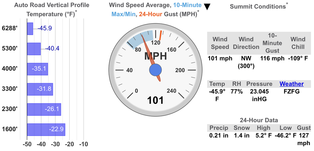
This AfternoonSnow. The snow could be heavy at times. High near 11. Wind chill values between -15 and -22. Windy, with a west northwest wind 29 to 34 mph, with gusts as high as 60 mph. Chance of precipitation is 80%. Total daytime snow accumulation of 32 to 38 inches possible.TonightSnow. The snow could be heavy at times. Temperature rising to around 12 by 11pm. Wind chill values between -11 and -17. Windy, with a southwest wind 24 to 34 mph increasing to 39 to 49 mph in the evening. Winds could gust as high as 70 mph. Chance of precipitation is 100%. New snow accumulation of 44 to 50 inches possible.SaturdaySnow. The snow could be heavy at times. Steady temperature around 10. Wind chill values between -9 and -18. Windy, with a west wind 44 to 49 mph decreasing to 36 to 41 mph in the afternoon. Winds could gust as high as 70 mph. Chance of precipitation is 100%. New snow accumulation of 20 to 26 inches possible.Saturday NightSnow. The snow could be heavy at times. Low around 12. Wind chill values between -8 and 2. West southwest wind 17 to 20 mph, with gusts as high as 25 mph. Chance of precipitation is 100%. New snow accumulation of 17 to 23 inches possible.SundaySnow. The snow could be heavy at times. High near 21. Windy, with a southwest wind 20 to 30 mph increasing to 30 to 40 mph in the afternoon. Winds could gust as high as 55 mph. Chance of precipitation is 100%. New snow accumulation of 23 to 29 inches possible.Sunday NightSnow. The snow could be heavy at times. Low around 16. Chance of precipitation is 90%. New snow accumulation of 16 to 22 inches possible.-
1
-
-
47 minutes ago, WinterWolf said:
Goes down almost 10mb in 6 hrs…and it was already at historic strength… mother of god.
Is it really asking too much for something like that?
-
1
-
-
-
1 hour ago, powderfreak said:
Until you’ve walked down a set of steep stairs in ski boots, it’s hard to know lol. Like all the memes that say the most dangerous thing you did at a ski resort was walk downstairs to the basement bathrooms in a base lodge
 .
.
The best are the ones who walk down stairs backwards in boots lol
-
2
-
-
After i guess
-
1
-
1
-
1
-
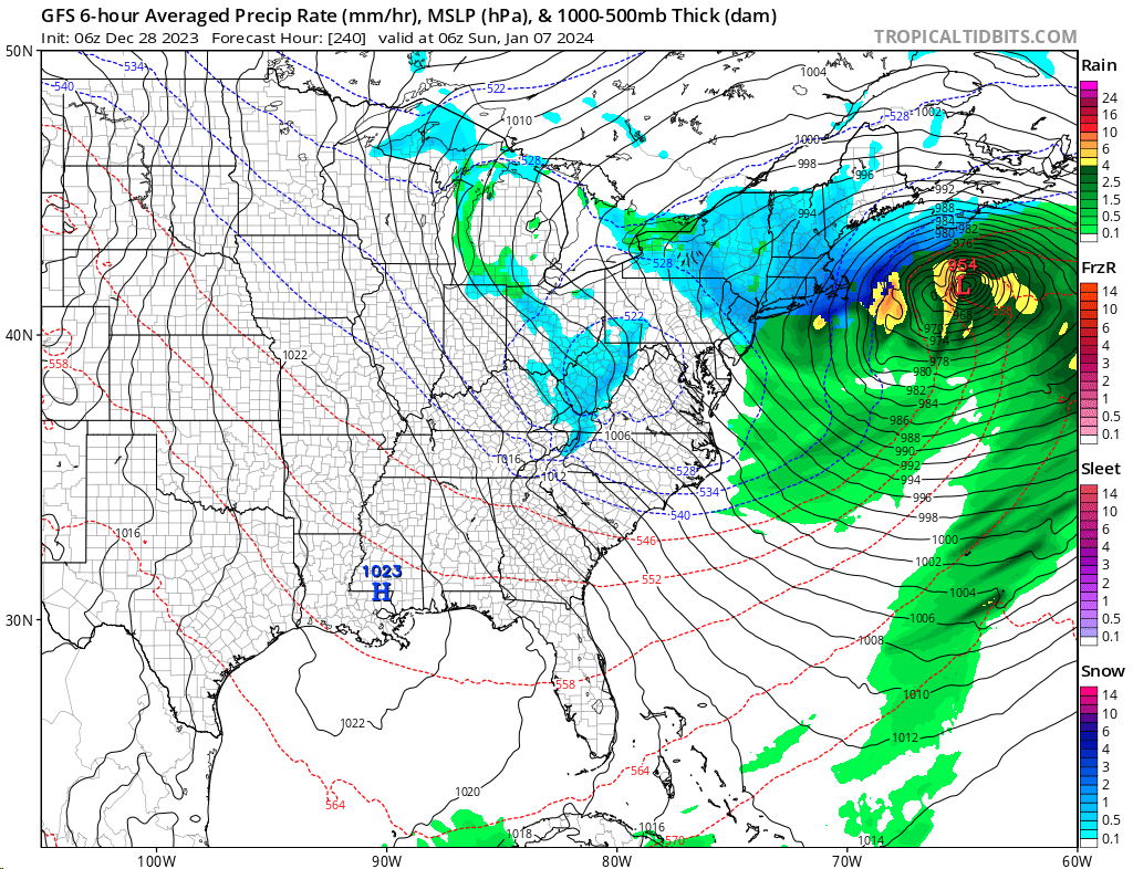

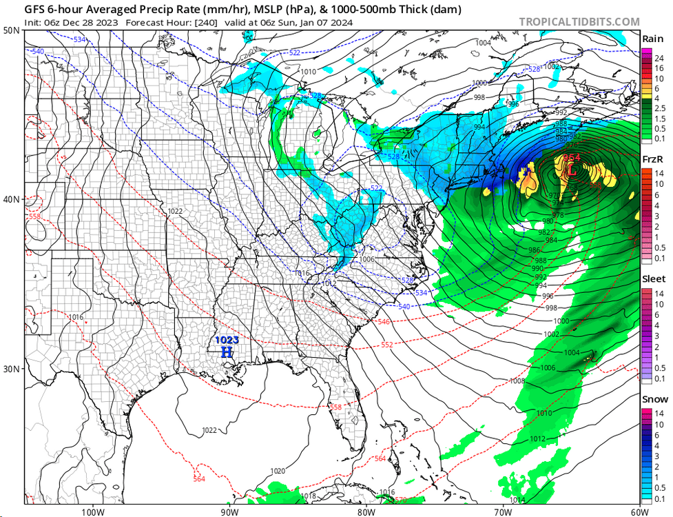
Two Mdt to high impact events NYC subforum; wknd Jan 6-7 Incl OBS, and mid week Jan 9-10 (incl OBS). Total water equiv by 00z/11 general 2", possibly 6" includes snow-ice mainly interior. RVR flood potential increases Jan 10 and beyond. Damaging wind.
in New York City Metro
Posted