

wotan
-
Posts
88 -
Joined
-
Last visited
Content Type
Profiles
Blogs
Forums
American Weather
Media Demo
Store
Gallery
Posts posted by wotan
-
-
Jeff Piotrowski
https://www.pscp.tv/w/b6H9RzF6dkVOcFlZZWxQS2V8MXZBeFJXWWFRVllLbL8bJ2E-IrV1QMy2P5ew5GphnHVGKH-Tu5IKRCv9Ubj4?t=26s
Sent from my Pixel 3 XL using Tapatalk -
Not good.

Sent from my Pixel 3 XL using Tapatalk -
I can confirm these West Houston storms are producing a lot of lightning.
Sent from my Pixel 3 XL using Tapatalk -
Now to watch TWC walking back yesterday's Torcon forecast for tomorrow.
-
But there's a Torcon of 6 for parts of Oklahoma and Texas Wednesday!Wednesday looks like the least likely day for widespread tornadoes compared to today and Tuesday. That squall line Tuesday night is going to really work everything over I don’t see the airmass recovering behind it enough at this point. Could be wrong, but most times when we count on recovery behind and MCS it doesn’t happen.
Sent from my Pixel 3 XL using Tapatalk
-
 1
1
-
-
TWC seems to be overplaying the tornado risk Wednesday. Shocking, I know.
Sent from my Pixel 3 XL using Tapatalk -
Anyone find out how the wind farm held up to the Tohoka tornado yesterday?
-
The gif was too large to attach here
Sent from my Pixel 3 XL using Tapatalk
-
 2
2
-
-
Large hail report

Sent from my Pixel 3 XL using Tapatalk -
There's already been golf ball size hail in a couple of storms. Still plenty of time.At the rate things have been going it's questionable whether the hail threat even pans out
Sent from my Pixel 3 XL using Tapatalk
-
Weather Channel is really overplaying the tornado threat tonight.
Sent from my Pixel 3 XL using Tapatalk -
Interesting thread:
-
1
-
-
Just now, Superstorm93 said:
Usually reserved for widespread damaging wind events.
Here's an example https://www.spc.noaa.gov/products/watch/2017/ww0280.html
Ahhh. I was thinking very large hail could also trigger one.
-
1 minute ago, jojo762 said:
There is no such thing as a PDS Severe Thunderstorm warning... What are you referring to?
I meant watch.
-
Out of curiosity, what are the thresholds for a PDS Severe Thunderstorm Watch? I hadn't previously really thought about it for this, but the newly updated Day 2 Outlook has the following probabilities:
Edited to correct Warning to Watch.
Quote...MAXIMUM RISK BY HAZARD... Tornado: 5% - Slight Wind: 30% - Enhanced Hail: 30% SIG - Enhanced
-
8 minutes ago, CheeselandSkies said:
Big downtrend for Iowa with the 15% barely nudging into the SE corner of the state after most of the state being in the Day 4 30%. Looks like SPC is leaning more towards the NAM, which remains worlds apart from the GFS which has actually increased the EHI over the area on recent runs.
Not impressed with this system as it gets closer, at this point not looking like a significant tornado event for anyone.
QuoteWith flow aloft forecast to gradually strengthen as the trough advances, shear sufficient for supercells will reside across much of the area by afternoon. As such, developing storms will likely become quickly severe given the degree of CAPE expected, with very large hail likely to be the primary severe risk. Greatest risk for the largest hail appears to exist across the southern Plains, near the axis of steepest lapse rates associated with the elevated mixed layer advecting northeastward from northern Mexico/New Mexico. Damaging wind gusts will also be possible locally, and a tornado or two cannot be ruled out. Convection will continue overnight -- spreading eastward toward the Mississippi River, but severe risk should gradually diminish overnight.
-
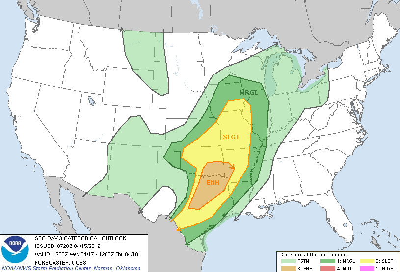
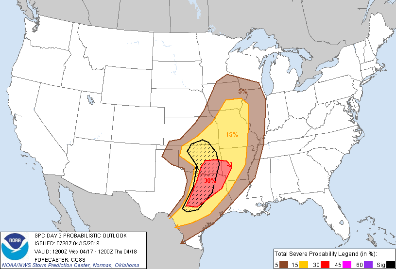
Day 3 Outlook
-
The moderate risk area is pretty much a hole.Interesting how this Tornado outbreak seemed to skip over Louisiana and the 2-7pm window when a lot of Tornados usually occur. Most of the activity was in the morning or overnight.
Sent from my Pixel 3 XL using Tapatalk
-
Hamilton, MS
Sent from my Pixel 3 XL using Tapatalk
-
Goshen, AL earlier this morning
Sent from my Pixel 3 XL using Tapatalk
-
Hamilton, MS
Sent from my Pixel 3 XL using Tapatalk
-
Wow!
Sent from my Pixel 3 XL using Tapatalk
-
2
-
 1
1
-
-
James Spann is live on Facebook.
Sent from my Pixel 3 XL using Tapatalk -
It appears to be back.

Sent from my Pixel 3 XL using Tapatalk
Severe storms and flash flooding for May 7-13
in Central/Western States
Posted
Sent from my Pixel 3 XL using Tapatalk