

wotan
-
Posts
88 -
Joined
-
Last visited
Content Type
Profiles
Blogs
Forums
American Weather
Media Demo
Store
Gallery
Posts posted by wotan
-
-
The lightning was spectacular last night.
Sent from my Pixel 3 XL using Tapatalk -
Raining in the stadium. This is not uncommon in heavy rain. The game should have been postponed.27,000 people were at the Astros game. Many left but still a good crowd. They might be stuck.
Sent from my Pixel 3 XL using Tapatalk
-
Closer to northwest but I know the area.You beat me to it. Didn't have a quarter to compare it to, but ours looked about like that. I had to help wrestle a couple of completely wired kids so getting GOOD photos of the hail didn't happen.
"Here" is about a mile NE of the #2030 gauge at Buffalo Bayou at Greenbusch Road - I think that's a few miles N-NW of you.
Sent from my Pixel 3 XL using Tapatalk
-
At my home.

Sent from my Pixel 3 XL using Tapatalk-
 2
2
-
-
Softball size hail being reported on Onalaska up on Lake Livingston
Sent from my Pixel 3 XL using Tapatalk-
1
-
-
The rain here is heavier than the radar indicates.

Sent from my Pixel 3 XL using Tapatalk -
That's where I am. Just outside the flash flood warning.Looks heavy on the Western side of the metro as of right now.
Sent from my Pixel 3 XL using Tapatalk
-
During Harvey, I had some extremely narrow and extremely heavy convective bands training over me. The exact same thing is happening tonight. It may not be raining a mile or two away.
Sent from my Pixel 3 XL using Tapatalk -
It's seriously nasty here.Bumping this for serious flooding expected in Hoston Metro, warning out.
Sent from my Pixel 3 XL using Tapatalk
-
I'm in Katy as well. Coming home just now on Westpark near 6 I had 5 or 6 drops on my windshield. And this is basically what my truck thought it was all the way home from the medical center.I'm currently in Katy, Texas, where it's been sticky-hot for a couple of hours - no thermometer here, unfortunately - as activity initiated mostly further east. But in the last few scans there is some activity starting to pop up around Houston and points south. EMS here is preparing for intense heavy rain and flooding, with Harvey's floods still very fresh in their minds.Sent from my Pixel 3 XL using Tapatalk

-
https://www.weather.gov/hgx/190424BryanTornadoIsn't this the 2nd tornado in a couple of weeks near Texas A&M ?
Sent from my Pixel 3 XL using Tapatalk
-
6 minutes ago, mob1 said:
Strong embedded rotation with this storm but we all know the real reason I'm posting it is because of the town's cool name.

Well SW of there, near Madisonville, is the town of North Zulch. It sounds like it came straight out of a Dr. Seuss book.
-
 3
3
-
-
2 minutes ago, Chinook said:
Isn't this the 2nd tornado in a couple of weeks near Texas A&M ?
Yes, actually. They had that weird one that popped up out of something not much bigger than a rain shower.
-
1
-
-
Heading in the direction of Kyle Field.New tornado warning for College Station area.
Sent from my Pixel 3 XL using Tapatalk
-
It's kind of straddling the HGX/FWD CWAs. The warning is being duplicated by both.Sheriff reported a tornado with some debris with that storm about 30 minutes ago but seems to have occluded shortly thereafter.
Sent from my Pixel 3 XL using Tapatalk
-
TOR issued for Franklin, TX, which was hit hard a few weeks ago.
Sent from my Pixel 3 XL using Tapatalk-
1
-
-
2 minutes ago, J_Prothro said:
Somewhere around Rocky. Found other pics in a Facebook post but it's a hard one to embed.
Take a screenshot and upload it here. That's really the only way.
-
Just now, J_Prothro said:
Damage pics coming in
Do we know the location on this one?
-
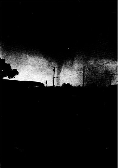
8 hours ago, mob1 said:
These images are breathtaking, there's something eerie about nighttime tornadoes.

I believe this is the only photo of the 5/22/87 Saragosa tornado. From the WP article about that one:
QuoteHowever, at 8:16 PM, another tornado touched down just east of the town about 2 miles (3.2 km) from Saragosa, north of Interstate 10. Initially, it destroyed farms and outbuildings before evolving into a large multiple vortex tornado before entering Saragosa while intensifying sharply into a violent F4 tornado. Twenty-two people were killed inside Catholic Hall of Our Lady of Guadalupe Church, where a graduation ceremony for pre-schoolers was taking place. Eight others were killed elsewhere across the town, including one inside a car.
The worst of the damage occurred inside most of the business and residential area. Trees were debarked and homes were reduced to their foundations. Eighty percent of the town was destroyed. In addition to Catholic Hall, 118 homes, the post office, a grocery store, two churches and a school were also heavily damaged or destroyed.[1][2] Damage was estimated at about $1.4 million. The path length of the tornado was nearly 3 miles (4.8 km) long and about 800 meters wide.[3]
One of those instances of a violent tornado with an amazingly short path length.
-
It's been reported that up to 400 homes in Kingwood in NE suburban Houston flooded from yesterday's rains. I also just saw an LSR come across that an apartment complex in Eagle Lake, well to the west of Houston, flooded. Eagle Lake had a tornado on Friday.
-
The good people at HGX are exhausted this morning.
QuoteBULLETIN - IMMEDIATE BROADCAST REQUESTED FLOOD WARNING NATIONAL WEATHER SERVICE HOUSTON/GALVESTON TX 726 AM CDT WED MAY 8 2019 TXC015-039-071-089-157-167-201-481-081815- /O.NEW.KHGX.FA.W.0006.190508T1226Z-190508T1815Z/ /00000.0.ER.000000T0000Z.000000T0000Z.000000T0000Z.OO/ COLORADO TX-WHARTON TX-AUSTIN TX-GALVESTON TX-FORT BEND TX- BRAZORIA TX-CHAMBERS TX-HARRIS TX- 726 AM CDT WED MAY 8 2019 THE NATIONAL WEATHER SERVICE IN LEAGUE CITY HAS ISSUED A * FLOOD WARNING FOR... EAST CENTRAL COLORADO COUNTY IN SOUTHEASTERN TEXAS... NORTHEASTERN WHARTON COUNTY IN SOUTHEASTERN TEXAS... SOUTHEASTERN AUSTIN COUNTY IN SOUTHEASTERN TEXAS... NORTHWESTERN GALVESTON COUNTY IN SOUTHEASTERN TEXAS... FORT BEND COUNTY IN SOUTHEASTERN TEXAS... NORTHERN BRAZORIA COUNTY IN SOUTHEASTERN TEXAS... WESTERN CHAMBERS COUNTY IN SOUTHEASTERN TEXAS... SOUTHERN HARRIS COUNTY IN SOUTHEASTERN TEXAS... * UNTIL 115 PM CDT WEDNESDAY. * AT 713 AM CDT, DOPPLER RADAR AND AUTOMATED RAIN GAUGES INDICATED THAT HEAVY RAIN WAS FALLING OVER THE AREA. HEAVY RAINFALL HAS CAUSED FLOODING OVER THE WARNED AREA, AND FLOODING IS ONGOING. UPWARDS OF 8 TO 12 INCHES OF RAIN HAVE FALLEN IN THIS AREA OVER THE PAST 24 HOURS. * SOME LOCATIONS THAT WILL EXPERIENCE FLOODING INCLUDE... PASADENA, PEARLAND, LEAGUE CITY, SUGAR LAND, BAYTOWN, MISSOURI CITY, FRIENDSWOOD, LA PORTE, DEER PARK, ROSENBERG, ALVIN, STAFFORD, SOUTH HOUSTON, BELLAIRE, WEST UNIVERSITY PLACE, SEABROOK, RICHMOND, GALENA PARK, JACINTO CITY AND WEBSTER. PRECAUTIONARY/PREPAREDNESS ACTIONS... TURN AROUND, DON'T DROWN WHEN ENCOUNTERING FLOODED ROADS. MOST FLOOD DEATHS OCCUR IN VEHICLES. EXCESSIVE RUNOFF FROM HEAVY RAINFALL WILL CAUSE FLOODING OF SMALL CREEKS AND STREAMS, URBAN AREAS, HIGHWAYS, STREETS AND UNDERPASSES AS WELL AS OTHER DRAINAGE AREAS AND LOW LYING SPOTS.
There's no rain falling in that area, and only some very light showers elsewhere.
-
Hgx finally issued a flash flood watch.
Sent from my Pixel 3 XL using Tapatalk -
More than likely farm equipment, center pivot sprinklers, and cattle.It had a few really impressive velocity scans as it passed near or over Howardwick TX just now. Hopefully there was nothing on the ground.
Sent from my Pixel 3 XL using Tapatalk
-
1
-
-
It's rural, but that's the southern transcontinental route. Always lots of traffic.
Sent from my Pixel 3 XL using Tapatalk

Severe storms and flash flooding for May 7-13
in Central/Western States
Posted
Plenty of people drove into flooded roads, again. There's really no excuse for that here by now, TBQH.