

NTXYankee
-
Posts
390 -
Joined
Content Type
Profiles
Blogs
Forums
American Weather
Media Demo
Store
Gallery
Posts posted by NTXYankee
-
-
7 hours ago, nwohweather said:
Sir are you calling today a bust? Goodness, it may have lacked tornadoes but there was incredible spread of severe weather and a derecho barreling through OhioI wouldn’t call what came through Ohio a derecho. The line literally fell apart as it was moving through Ohio’s typical hostile environment for a good thunderstorm in the central part of state. I’ve seen general storms with more bang than what we got last night.
-
12 hours ago, snowlover2 said:
The new day 3 disco is short but with strong wording calling for a MCS with possible destructive winds because of extreme instability and also saying upgrades being likely in later outlooks.
https://www.spc.noaa.gov/products/outlook/day3otlk.html
They can’t even get today right let alone day 3.
-
Great looking forward to the same old June crap. Leftover rain blobs, no storms, and miserable below normal temperatures.
-
4 hours ago, snowlover2 said:
12z Euro appears to have a strong looking MCS next Saturday evening/night developing across southern MI to E IA and dropping south across much of IL/IN/OH.
Yeah and the models had us under torrential rain and storms several days out to only be incorrect and well south this weekend, which I am fine with, though a decent thunderstorm would have been nice. By Friday we’ll probably be under a trough and in the 60’s...
-
On 6/9/2019 at 2:21 PM, Hoosier said:
Just gotta laugh how a -NAO was so hard to come by last winter, but has been so prevalent in the past couple months. I think the correlation with temps does become less as you get into summer, meaning that a -NAO is not as likely to result in below average temps (for example, 2012 was a -NAO summer). This is where looking at actual maps/patterns helps.

A 2012 summer can start at anytime now.
-
 4
4
-
-
On 6/8/2019 at 10:44 PM, wisconsinwx said:
Actually, a cold, dry winter and a warm/hot, dry summer is the worst combo. I think most weather enthusiasts here would agree, except those who only like big temp records.
Well severe weather season has been in the crapper here in central Ohio, the rest of Ohio has done fairly well, so I’ve given up on that changing. I will gladly take a warm/hot dry summer instead. I need something to forget the long snowy winter and prepare for next season. Maybe 7 years in Texas spoiled me on expectations this far north.
-
7 hours ago, Hoosier said:
Yes that is the 540 line.

This pattern is crap, nothing worse than a cold winter and cold summer.
-
3
-
-
2 hours ago, Indystorm said:
Garden variety t storm here just ne of Indpls. Looks like more severe storms will develop to the east of me in the watch.
LOL They died as quick as they entered. Welcome to Ohio.
-
Well I am taking a break from weather, this season is crap at least for Central Ohio, it’s turned into either a dying complex or everything goes around. If I hear thunder it may storm if I hear a siren maybe a tornado, lol. Time to enjoy the heat.
-
Probably a good thing I haven’t watered flowers, etc. If everything in Indiana continues to develop and move SE towards Columbus heavy rain probably a decent bet.
-
4 minutes ago, Indystorm said:
Look what is forming this evening from northern IN westward across northern IL into IA. Maybe those mesoscale models that predicted training west to east t storms overnight are going to be correct in spite of the MCS that rolled through the area earlier today.
Saw that, seemed to start popping up pretty quick. HRRR says Columbus around 5z so we’ll see out this way.
-
3 hours ago, cyclone77 said:
Miserable day to be sure. Hopefully we can get cape to exceed 500J/kg at some point before July.

I know makes you wonder. This pattern has been miserable. I tolerate winter to look forward to severe weather season and now I’m just getting cranky and want a massive heat ridge to just put it to bed for the year and use the pool.
-
1
-
-
On 5/5/2019 at 5:26 PM, geddyweather said:
Talking about rain, flooding, and below avg temps is getting a bit exhausting. Here's some severe bits to nibble on...
Day 4 (Wednesday): Main show appears to be out in "classic" tornado alley but a good chunk of MO is included. Wouldn't be surprised to see some action spill into southern IL as well late in the day.
Day 5 (Thursday): Long area from Cleveland, OH all the way down to Waco, TX. Really not sure about how the subforum fairs for this one. I'm not TOO impressed but its something. Plenty of shear, but moisture and heating potentially lacking due to questionable warm sector advancement amongst other things. Same old story. Could see southern parts of the region (ie: central/southern IN, southern OH, northern KY, etc) having some fun as those areas always seem to do really well on the 50/50 days like this.
G
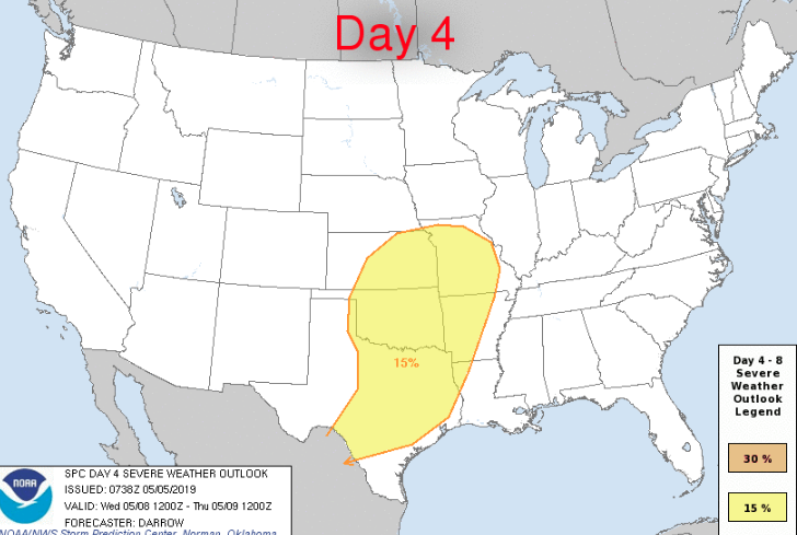
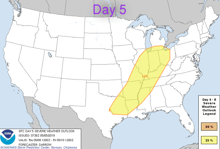
lol looks like we’ll have to continue talking about it because this threat went poof. Maybe by the end of the season with this crap pattern we’ll get to page three in this thread.

-
Just now, 1900hurricane said:
Lot of junk in the inflow of that cell might be what's keeping it from taking off.
I hope so. I have friends in Roanoke to the west of the city
-
Yuck. You could not pay me enough to live that far north, I think Columbus winters are long.
-
1
-
 1
1
-
-
38 minutes ago, NegativeEPO said:
Have a feeling we're going to see something similar this year.
Not cool resurrecting an old thread.
-
14 minutes ago, NegativeEPO said:
wow, finally a decent warm-up!

Oh wait, it's Spring 2019... back into the trash cold a couple days later that will probably lock in for the rest of the month. Barely into the 40s lakeside... absolutely brutal stuff.

GFS isn't any better. In fact, it's showing possible record cold towards the end of the month into the beginning of May. I've accepted that this is the new normal now though. As the arctic continues to warm at an alarming rate, the midwest/east will be its dumping ground for cold. Warming waters combined with melting sea ice contributes to the non-stop ridge that has been present in Alaska and the Arctic, and that ridge forces the cold south. The cold has to go somewhere after all, and it takes direct aim at us... ALWAYS. As the rest of the planet continues to warm, average temperatures in the eastern CONUS will continue to decline, to the point where April snows (possibly even May snows) might become a common occurrence. Again, this is all related to climate change and a warming arctic/melting ice caps. Its effects are already irreversible, so we may as well accept it at this point. It will only get worse as time goes on too, perhaps even catastrophic at some point.
I think even AOC would find you mildly entertaining.
-
Not even a thunderstorm
I would say Thursday might be better but I won’t hold my breath.
-
2 minutes ago, Jackstraw said:
Pretty crazy, 6 TOR watches and only 2 TOR reports so far.
Everything starts to look good then just falls apart.
-
Does anyone know if a TOG north of Springfield? Storm has a well defined hook on radar
-
Just now, WxLaura said:
osu's weather station is reporting 78 temps with 62 dew points. iirc forecasted high was only around 73
John Glenn International is reporting 77 so seems right. Yeah low 70’s was the call. Sun still blasting too
-
A lot more humid in Columbus than just even an hour ago and temperatures in 70’s.
-
Tornado watch now Columbus south
-
32 minutes ago, BrandonC_TX said:
Those temperatures seem to be rising like a rocket ship... upper 60s to near 70 around Cincinnati now, with mid-to-upper 50s in Columbus based on Wundermap data. I'm eagerly awaiting the 1630z SPC outlook.
The storms west of Louisville seem to be behaving themselves right now, but with temperatures in the lower-to-mid-70s (and dews in the upper 50s to lower 60s) out ahead of them, I don't know how much longer that will be the case. If those dews can get any higher, I bet it's only a matter of time before they strengthen.Now that more consistent sun has been out I expect temps to really start climbing. Winds have started picking up


Spring/Summer 2020 Banter/Complaint Thread
in Lakes/Ohio Valley
Posted
Not surprised. Another crappy year for severe weather up here. This whole virus thing, stuck at home, and can’t even work in the yard without wearing layers is aggravating. If the weather was decent it would at least be tolerable.