

J.Spin
-
Posts
6,156 -
Joined
-
Last visited
Content Type
Profiles
Blogs
Forums
American Weather
Media Demo
Store
Gallery
Posts posted by J.Spin
-
-
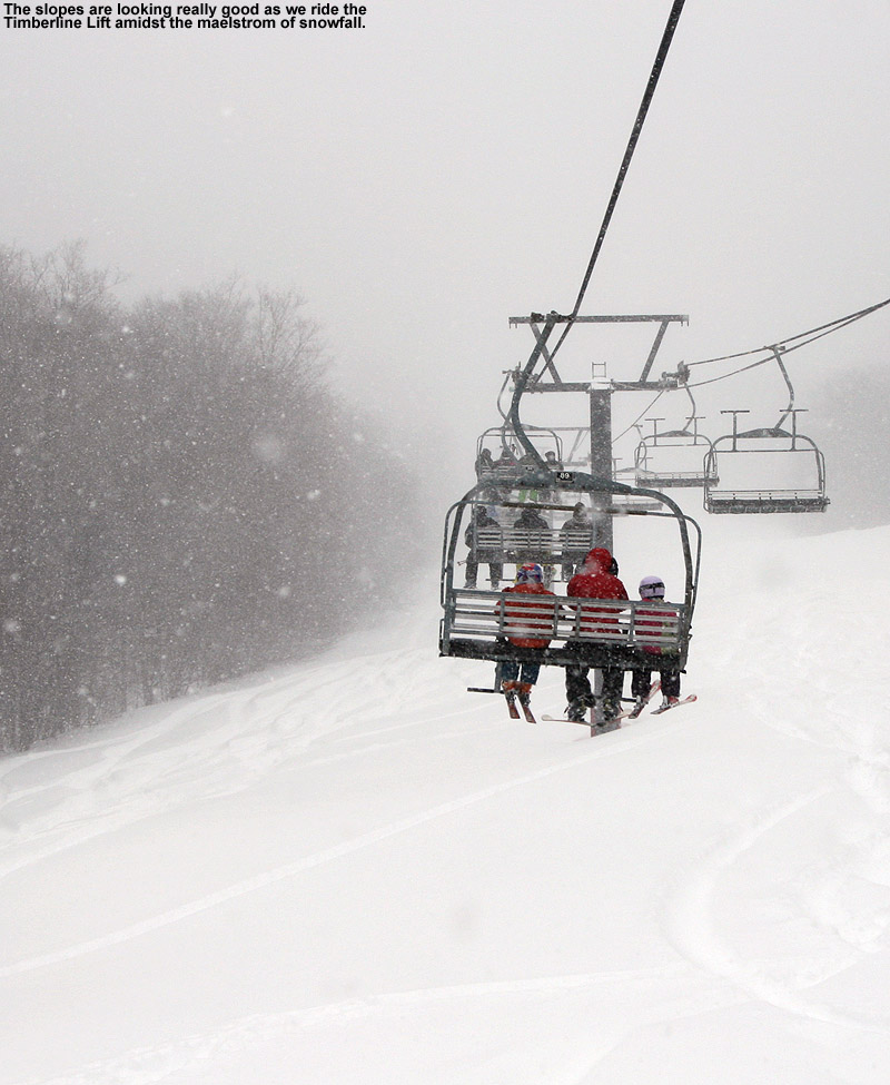
16 minutes ago, powderfreak said:
Yeah snow growth is pretty poor here. Seems to be precipitating fairly efficiently but no more than 8-10:1 ratios I'd imagine? Pretty dense at the mountain, which is what is needed.
I did a check on the snow depth difference on the boards in roughly the 9:30 A.M. to 10:00 A.M. block, and it was 0.5”, so I guess the snowfall is around the 1”/hour mark.
The current snowfall is relatively dense as you mentioned, which is especially helpful as we get deeper into spring and the subsurfaces are firmer because they’ve typically gone through freeze/thaw cycles. That dense start was somewhat lacking in the past few storms as I wrote up previously. I think it failed set up great bonding to the subsurface, was pushed around quickly, and led to poorer ski surfaces than we otherwise might have seen. We probably would have needed 2”+ of liquid equivalent to really make a notable difference in that situation:
“The recent clippers from this week were nice, and were potent enough that they made for some great short term conditions while the snow had its loft, but there just wasn’t enough liquid equivalent in there to really set up for lasting improvement in the on piste snow surfaces. Those systems, and even Winter Storm Oaklee before it, were fairy cold from start to finish. That meant that there wasn’t any notable dense snow to bond to the underlying subsurface, and the light, dry snow eventually just gets pushed around, bringing you back to whatever hard base was there before. My snow analysis numbers show that these past four storms (there was also a smaller system with squalls between Oaklee and the two larger clippers) actually put down over an inch of liquid equivalent here in the valley. But despite there likely being somewhat more liquid equivalent than that in the mountains, it wasn’t going to be enough to hold up to lift-served levels of skier traffic.”
-
 1
1
-
-
2 minutes ago, powderfreak said:
Yeah snow growth is pretty poor here. Seems to be precipitating fairly efficiently but no more than 8-10:1 ratios I'd imagine? Pretty dense at the mountain, which is what is needed.
Flake size has been up and down a lot here at our site this morning, going from 1-2 mm such as at observations time and early on, with some periods getting up to the 10-15 mm range. Right now it’s a mix of sizes that looks to cover roughly the 3-15 mm range.
-
-
10 minutes ago, powderfreak said:
Seeing some meso-band signs streaking SW to NE. Looks to be nosing over J.Spin.

I actually just checked in because I saw that on the radar. Even with those 30 db echoes, it hasn’t been anything too outrageous here on the ground thus far, just moderate snowfall by eye. There’s a fresh inch on the boards at the moment, and we’ll see what accumulates as it pushes through the area.
-
Event totals: 0.3” Snow/0.14” L.E.
This morning’s snow core contained 0.11” of liquid, while the rain gauge contained 0.14” of liquid, so it looks like there was 0.03” of front end rain from this system before the snow got going. I did see some spots of rain late last night before heading off to bed, so that must have persisted during the overnight hours for a time.
Details from the 6:00 A.M. Waterbury observations:
New Snow: 0.3 inches
New Liquid: 0.11 inches
Snow/Water Ratio: 2.7
Snow Density: 36.7% H2O
Temperature: 33.1 F
Sky: Light Snow (1-2 mm flakes)
Snow at the stake: 6.5 inches
-
This will probably be the last BTV NWS map update for this upcoming storm (given the name Winter Storm Quinlan), since it’s expected to begin affecting that area tonight. Winter Storm Warnings cover much of the area now, and the latest Event Total Snowfall map through 1:00 A.M. Sunday shows the latest thoughts from the BTV NWS. Most of VT is in that 8-12” shading as in the previous couple of maps, with 12-18” along the spine of the Northern/Central Greens, but there’s also a bit of the 18-24” shading that crept back into those highest elevations in the Northern Greens. The point forecasts at elevation do have some snowfall numbers that correspond roughly to that range, with 15-25” for the Mansfield area and 18-28” for the Jay Peak area. Our snow forecast here in the valley is in the 8-14” range. I see that that EMontpelierWhiteout posted the latest BTV NWS forecast discussion, which provides their thinking behind the numbers.


-
Early this morning the text came out that the BTV NWS has progressed our area into a Winter Storm Warning, and much of the area west of the Connecticut River Valley appears to be in that boat at this stage. The Event Total Snowfall map through 1:00 A.M. Sunday looks fairly similar to the previous version, with 8-12” shading covering much of the state, and 12-18” shading near the spine of the Northern/Central Greens. The forecast discussion indicates that there was a minor general increase in the projected snowfall across the region of about an inch since the previous forecast. Our point forecast through the period appears to come in just shy of 12-18” through Sunday, which generally fits with the map.


-
37 minutes ago, powderfreak said:
I truly am not sure what to think. The models have been jumping around quite a bit. It's going to snow, that's for sure as rain is now off the table. I do question if we get the QPF amounts shown on some of these progs to reach those higher BTV forecast amounts. The mid-levels don't close off and it's a positively titled trough. Great frontogenesis from the strong thermal gradient but still not a set-up that screams high-end snowfall with the open waves aloft and progressive nature. We'll see. I like a widespread 6-12" for most of us posters, with best chance of 12"+ being the Spine depending on how the backside upslope goes.
I really don’t feel that your thinking is far off from that latest BTV NWS Storm Total Forecast Map – the vast majority of the state is shown in that 8-12” shading, and the areas of 12-18” shading are generally along the spine of the Northern/Central Greens. If the modeled projections are trending one way or another, you know they’ll adjust as needed in the overnight update.

-
I’ve got the latest maps from the BTV NWS afternoon updates. The Winter Storm Watches have expanded substantially, except to the southeast. As on the previous Storm Total Forecast Map, they’ve got that 12-18” shading along the spine, with a bit of the 18-24” shading to cover the usual highest elevation spots in the Northern Greens. Our current point forecast here in the valley suggests accumulations in the 9-15” range. We’ll see what they do with the overnight updates when the next couple of model runs are considered.

-
1 hour ago, mreaves said:
Winter Storm Watch up.

I received a text around 3:00 A.M. with a notification about the Winter Storm Watch, and I guess it shouldn't be too surprising since the BTV NWS was already mentioning that alerts would likely be coming soon in their discussion yesterday. The current alerts map does show the watches all the way down into SVT, but not quite wall to wall farther south. The point forecast here has 8-12” through Saturday, but doesn’t include the evening yet, so the 12-18” shading around here seems like it fits at this point.

-
Event totals: 0.8” Snow/0.02” L.E.
The snow from yesterday’s storm system had finished up by midnight, and the totals above should be the final numbers for that event.
Details from the 6:00 A.M. Waterbury observations:
New Snow: 0.8 inches
New Liquid: 0.02 inches
Snow/Water Ratio: 40.0
Snow Density: 2.5% H2O
Temperature: 29.5 F
Sky: Partly Cloudy
Snow at the stake: 8.5 inches
-
5 hours ago, bobbutts said:
If you haven't tried it check out Zardoz not wax. Works really well on that sticky snow. Like a total game changer on sticky snow.
Thanks for the heads up. I have used fluoro wax before, but not Zardoz specifically as far as I recall. I’ll definitely get some to add to my supplies – they say it’s especially good for warm snow.
I’d put some standard Swix rub on wax on our skis as I usually do, and it helped, but fluoro is sort of the king when it comes to ski wax. Thankfully, we didn’t actually find that conditions on the flats as bad as the guys we’d talked to in the parking lot, and I’ve definitely seen it worse. I was on Teles, which can be brutal with respect to the effort required to keep fore-aft balance and prevent yourself from going over the handlebars all the time on really sticky snow, but I found that Sunday was at least reasonable compared to some days we’ve been out in the past.
-
1
-
-
Event totals: 0.2” Snow/0.31” L.E.
All I saw from this morning’s new snow was an additional tenth of an inch here at our site, so the numbers above should be the final totals for this system.
Details from the 6:00 P.M. Waterbury observations:
New Snow: 0.1 inches
New Liquid: Trace
Temperature: 26.2 F
Sky: Clear
Snow at the stake: 8.0 inches
The next potential system to affect the area with snow appears to be later in the day tomorrow based on the modeling and the BTV NWS forecast discussion.
-
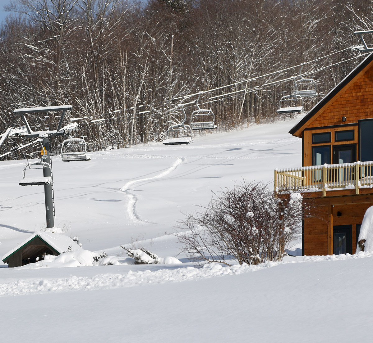
I’ve been a bit too busy so far this week to write up my weekend ski/snow observations, but I’ve had a few moments now to put some comments and images together. It was an absolute tale of two seasons out there this weekend, with midwinter conditions and powder available on Saturday, then beautiful warm weather and spring snow on Sunday.
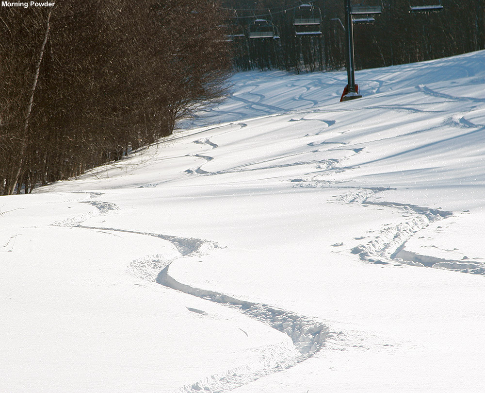
My wife and I headed out for some turns on Saturday morning, thinking that was clearly going to be the better day for skiing over the weekend. Temperatures were in the 20s F, so it was quite nice in that regard, but we were curious to see how the trail conditions were faring after the midweek clippers. Despite all the new snow, trail conditions were fairly poor, even at a relatively low traffic resort like Bolton. The powder that hadn’t been touched was actually skiing really well, but untracked areas were few and far between on the lift-served terrain after the completion of school vacation week and the extension of the break period into Monday and Tuesday that most local schools had. I actually think some low to moderate angle backcountry might have even been the better call based on the sharp contrast in snow quality between the on piste vs. off piste conditions we found.
The clippers were nice, and were potent enough that they made for some great short term conditions while the snow had its loft, but there just wasn’t enough liquid equivalent in there to really set up for lasting improvement in the on piste snow surfaces. Those systems, and even Winter Storm Oaklee before it, were fairy cold from start to finish. That meant that there wasn’t any notable dense snow to bond to the underlying subsurface, and the light, dry snow eventually just gets pushed around, bringing you back to whatever hard base was there before. My numbers show that these past four storms (there was also a smaller system with squalls between Oaklee and the two larger clippers) actually put down over an inch of liquid equivalent here in the valley. But even with somewhat more than that in the mountains, it wasn’t going to be enough to hold up to lift-served levels of skier traffic. Even more than usual on Saturday we found a huge difference between the quality of the manmade subsurfaces and the natural subsurfaces. My wife commented on it during one of our runs because the difference was so extreme that it jumped right out to her. Based on what we encountered, it seemed like the denser manmade base areas had an even harder time incorporating the new snow than the natural snow terrain.

I hadn’t planned to ski on Sunday, thinking it was just going to be a rainy day, but the sky cleared out in the afternoon to produce a beautiful, warm, early spring day. Seeing that, my younger son and I popped up to the mountain for some runs. In a classic reversal of Saturday, this was a situation where the terrain with manmade snow provided the superior skiing. Manmade snow is dense enough that it generally transitions quickly to an appropriate spring snow surface, while the natural snow initially gets sticky with warm temperatures and requires some freeze/thaw cycles before it really primes up. Trail pitch mattered as well, and low angle terrain was the toughest in terms of movement. We talked to a couple of guys in the parking lot who said that the flat terrain was brutally slow.
We spent our whole session on Sunday at Timberline, and the resort had recently put down a bunch of manmade snow under the quad that provided great turns in the warm temperatures. We did venture off to flatter terrain on one run per my son’s request, just to see what it was like. After that, the difficulty in traveling on flat terrain was made abundantly clear, and we just spent the rest or the time lapping the good snow on the Showtime trail under the Timberline Quad. The snow was great for railing carves and generally having a fun springtime ski session. Also, there was hardly anyone at the resort, probably because they had assumed it was going to be a dreary day like we’d thought. When we arrived in the early afternoon, there were three cars in the upper Timberline lot.


-
2
-
-
Event totals: 0.1” Snow/0.31” L.E.
Precipitation from this current system started up yesterday evening, and there was a loud downpour at some point, although I don’t recall the exact time. The precipitation had changed over to snow late last night, but I only found a fluffy tenth of an inch on the boards at observations time. Snow had just picked up at that point however, with a bit more accumulation that I’ll put into the next round of observations.
Details from the 6:00 A.M. Waterbury observations:
New Snow: 0.1 inches
New Liquid: Trace
Temperature: 27.3 F
Sky: Light Snow (5-15 mm flakes)
Snow at the stake: 8.0 inches
-
6 hours ago, powderfreak said:
As we discussed the groomer conditions are often much better without the big wide open exposed/steeper trails that get scoured and heavier traffic.
Yeah, I don’t want to give the impression that Stowe is any different than equivalent mountains around here with steep terrain and high speed lifts – I just focused on it specifically to address Alex’s comment. Jay, ‘bush, Killington, etc. are all in the same boat when there’s been a thaw/freeze without a resurfacing storm. Even the lower capacity places like Smugg’s, MRG, Bolton etc. are in that boat, they just have a little more time before conditions deteriorate because of lower levels of skier traffic.
The reality is that there’s no way to maintain decent snow quality on steep, on piste terrain after a thaw/freeze, unless there’s a significant resurfacing storm, or a resort wants to make a ton of snow and resurface a certain trail. The off piste and/or lower angle terrain are generally the places with far better snow quality in these situations.
-
1 hour ago, qg_omega said:
All of this is pretty absurd, 99 percent of skiers aren’t skiing natural in the woods
(shrug) I’m not sure what to tell you, aside from the fact that you must not ski around here in NVT a lot? Alex literally just wrote that they skied Sunrise/Birch glades several times and they were great, so they’re either part of that miniscule 1%, or your numbers are off.
-
3
-
-
15 hours ago, alex said:
I have to say, it’s amazing how icy the ski trails are in spite of all that powder. Love everything about Stowe but it’s about there with Cannon for ice, it seems!
14 hours ago, powderfreak said:It’s about knowing where to go, too. Use trails to get to woods. I don't know if it's the wide open, steeper pitches exposed to wind or what but there are definitely hills where trails seem firmer than others. If it requires winch grooming there’s a lot of skidding skiers and snow pushed downhill.
This is a different experience for sure than 2pm on Nosedive when the upper turns are blue ice.
Mt. Mansfield indeed gets incredible snowfall and has amazing terrain, but the resort suffers from a number of factors that come together to degrade many of the on piste surfaces:
· Steep pitches
· Significant areas of manmade snow
· High speed lifts
· Heavy skier traffic
· Notable population of strong, aggressive skiers
For many years we skied Bolton on Saturdays and then Stowe on Sundays with our boy’s ski program, and on many weekend the difference in snow quality on the typical on piste routes was not quite night and day, but sometimes close to that.
There was a fairly recent thaw, and we haven’t had a resurfacing storm, which is not at all uncommon in the Northeast in the winter. PF’s quote above of “Use trails to get to woods” is what most advanced/expert skiers are going to be doing.
My recommendations for an improved ski experience at Stowe without the ice would be:
· Don’t ski any trails with manmade snow.
· Don’t go near the main traffic routes like the Lord/North Slope route, Lift Line, or Nosedive areas off the quad, or most of the Side Street area on Spruce. These main routes, with manmade snow and Stowe’s incredibly high lift capacity, are recipes for disaster.
· Don’t ski any on piste areas with black pitch or higher, but practically speaking, don’t ski any on piste areas with even blue pitch or higher depending on how the combination of recent skier traffic vs. snowfall has played out.
· Ski areas like the Toll House pod, Sunrise Glades, Birch Glades, Chapel Woods, Tyro, Lower Tyro, Lower Standard, Lower Gulch, etc. If you look at the Stowe trail map, this is essentially everything to the map’s left (i.e. skier’s right) of Tyro/Lower Standard/Lower Gulch. With Stowe’s mountain layout, those are really just about the only areas on the mountain that have an appropriate combination of pitch, levels of skier traffic, and natural snow that will preserve the snow surfaces. There are other areas of the resort that fit that bill, but with the off piste included, that area has hundreds of acres to ski with a combination of snow, pitch, and skier traffic that is hard to beat anywhere at the resort. I have spent many, many days, skiing exclusive that part of the resort when conditions elsewhere were poor. The Meadows part of Spruce can sometimes be OK because of its pitch, but it still suffers from manmade snow and skier traffic, so you have to check to see what state it’s in.
· As much as your knowledge and abilities allow, do not ski on piste. On piste conditions are poor because of high levels of skier traffic and manmade snow. So go with exactly what PF says and simply use the trails to get to the woods.
-
5
-
-
Event totals: 3.8” Snow/0.15” L.E.
Details from the 6:00 P.M. Waterbury observations:
New Snow: 1.6 inches
New Liquid: 0.03 inches
Snow/Water Ratio: 53.3
Snow Density: 1.9% H2O
Temperature: 12.7 F
Sky: Partly Cloudy
Snow at the stake: 15.0 inches
The above totals should mark the end of this event, but there are apparently more in the storm queue: some models show a little something tonight, then there’s a rapidly moving shortwave dropping in from the northwest tomorrow night, then a larger system moving into the area on Saturday night, and yet another potential system in the Tuesday timeframe.
-
Event totals: 2.2” Snow/0.12” L.E.
Snow started up late last night and there was 2.2” on the boards this morning at observations time. Snowfall did pick up after that to the 1”/hr. range, so there will be additional accumulation to report in the next round of observations.
Details from the 6:00 A.M. Waterbury observations:
New Snow: 2.2 inches
New Liquid: 0.12 inches
Snow/Water Ratio: 18.3
Snow Density: 5.5% H2O
Temperature: 22.5 F
Sky: Light Snow (5-12 mm flakes)
Snow at the stake: 16.0 inches
-
Event totals: 4.2” Snow/0.18” L.E.
We actually did pick up a bit of additional accumulation from this morning’s residual flakes, so final totals for the storm are above. That should make the end of that system though, since the next one appears to be on our doorstep.
Details from the 6:00 P.M. Waterbury observations:
New Snow: 0.1 inches
New Liquid: Trace
Temperature: 24.1 F
Sky: Cloudy
Snow at the stake: 14.0 inches
-
Event totals: 4.1” Snow/0.18” L.E.
This is likely the last round of observations for this system, since there are plenty of blue sky patches out there now. The storm total was right in the 2-5” that the BTV NWS had in our point forecast, so great work there as usual. There are clouds to our west and a hint of echoes in WNW flow on the radar, so we’ll have to see if any flakes come out of that. The next system in the queue is projected to come into the area tonight.
Details from the 6:00 A.M. Waterbury observations:
New Snow: 0.7 inches
New Liquid: 0.03 inches
Snow/Water Ratio: 23.3
Snow Density: 4.3% H2O
Temperature: 16.0 F
Sky: Mostly Cloudy
Snow at the stake: 15.0 inches
-
Event totals: 3.4” Snow/0.15” L.E.
Details from the 12:00 A.M. Waterbury observations:
New Snow: 1.9 inches
New Liquid: 0.09 inches
Snow/Water Ratio: 21.1
Snow Density: 4.7% H2O
Temperature: 27.9 F
Sky: Light Snow (2-12 mm flakes)
Snow at the stake: 15.0 inches
-
Event totals: 1.5” Snow/0.06” L.E.
Details from the 6:00 P.M. Waterbury observations:
New Snow: 1.2 inches
New Liquid: 0.05 inches
Snow/Water Ratio: 24.0
Snow Density: 4.2% H2O
Temperature: 26.1 F
Sky: Light Snow (1-10 mm flakes)
Snow at the stake: 14.0 inches


NNE Cold Season Thread 2021/2022
in New England
Posted
It seems like it’s been running at about 1”/hr here at our site, nothing too outrageous, but nice and steady. I’m planning to run an analysis at 12:00 P.M. and we’ll get some info on the morning’s snow density down here in the valley.