
calm_days
-
Posts
258 -
Joined
-
Last visited
Content Type
Profiles
Blogs
Forums
American Weather
Media Demo
Store
Gallery
Posts posted by calm_days
-
-
14 hours ago, SN_Lover said:
I can't remember the last time we had a major severe weather outbreak. Wounder what this spring will be like.
Yes; Brick and others have been mentioning over the past few years that the once certain seasons for severe, especially autumn, have changed in that regard. I feel like it is at least a guaranteed interesting spring in terms of unusual weather systems, although I'm not sure if any would be severe, maybe just different enough to be noteworthy!
1 hour ago, CaryWx said:Yep, believe winter's over for most of us on this forum unless the models are waaay wrong.
I do think that there is at least a chance of a few to several colder wedge days during March and April.
-
This wind map format may be helpful:
(Surface winds:)
https://earth.nullschool.net/#current/wind/surface/level/orthographic=-88.55,38.14,3000
(850)
-
 1
1
-
-
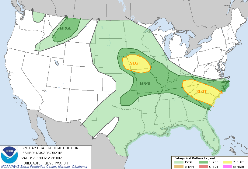
...Southern Appalachians to Carolinas...
Relatively steep mid-level lapse rates, as noted in 12Z observed soundings from locations such as Nashville and Atlanta, will continue to advect eastward toward the region.A mid-level shortwave trough and associated belt of modestly enhanced flow aloft will spread east/southeastward today over the region and influence deep convective development within a moist/moderately unstable environment along a quasi-stationary frontal boundary.
Initial thunderstorm intensification should occur this afternoon over the southern Appalachians vicinity as well as near the front, with the potential that storms will somewhat organize into clusters and small linear segments in the presence of around 30 kt effective shear. Damaging winds will be the most common hazard.
-
https://www.nature.com/articles/s41586-018-0006-5
Main Atlantic Ocean currents are changing: I didn't know about this until a few minutes ago! This more broad article is not mentioning the sea surface temperature differences that you are noticing, so it is important to hear a direct firsthand report.
The past two summers have definitely been cooler (but not completely cool), a simple aspect of that being the length of time it has taken for RDU to eventually reach 90.
-
Not wishing to get too abstract but I think it fits well in this topic: it does seem like this May, June and July will be unusual in terms of weather conditions. It almost seems possible that there could be one or two very different weather system interactions, perhaps three or four depending on what these conditions will actually be.
I don't get a sense that it would be too extreme or noteworthy in unwelcome ways. Though, should the direct and sizable west to east troughs continue, there would at some point be oceanic cyclone activity stirring up and pulled in their direction.
Wanting to post this is mostly stemming from a general curiosity about how the current patterns will actually resolve into any of the familiar summer patterns. A very comprehensive pattern shift is very possible too, but I wonder if it doesn't quite get there, we will have an unusual mix to observe and from which to learn, and hopefully enjoy too!
-
1
-
-
Until it is resolved and removed, it seems that they can be avoided by right-clicking and opening each desired page in a new tab, but left-clicking on links will activate the popups at least once.
-
I think this has already been a very enjoyable/fulfilling system to watch in forecasts, and hopefully, most likely, it will turn out to be intriguing as it happens and as the thread title mentions, good to remember into the future!
-
 1
1
-
-
Are there links available to track Gulf of Mexico methane? I can't tell if changes I have noticed in water vapor behavior in relation to the Gulf of Mexico are from integration of comet dust (ISON & LINEAR) or from possible increased release from underwater that have been theorized to be possible since 2010 and earlier.
Banter Thread
in Southeastern States
Posted
It is possible to make bookmarks that directly lead to an animated GIF of the wunderground radar!!")
Basically, you can configure the settings through this page, including changing to a different radar site.
https://www.wunderground.com/weather-radar/united-states/nc/raleigh-durham/rdu/
Mainly I would recommend setting the number of frames to 10 unless you prefer fewer! At the very bottom of the dark gray panel is the Save Image button. You can also right click the Save Image button and open a new tab if that is possible in your browser!
Either way it will hopefully open a GIF all by itself, and you will be able to make it a bookmark! Visiting the bookmark on another day is somehow able to run all of the same settings that you initially selected and produce an up to date new radar image!!
And of course, you can set up different zoom levels and radar angles, then, use the Save Image option again and you can bookmark those too!