
calm_days
-
Posts
258 -
Joined
-
Last visited
Content Type
Profiles
Blogs
Forums
American Weather
Media Demo
Store
Gallery
Posts posted by calm_days
-
-
Hopefully at this point of the future there is some protection from stronger storms due to the proximity of Sunny Point, as well as the nuclear power station!
https://en.wikipedia.org/wiki/Military_Ocean_Terminal_Sunny_Point
I am not sure what type of mitigation of hurricane strength is possible in 2021, but, it is doubtful that there has not been a safe and non-disruptive method discovered.
-
45 minutes ago, mclean02 said:
Agreed ! is there an app or web page that has a really good radar mosaic ? weather.gov used to be great but i really miss the old style before the upgrade of the site last year..
")
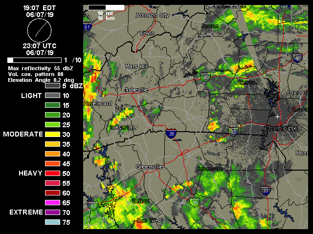
College of DuPage is really good i would say!
They have site specific NEXRAD https://weather.cod.edu/satrad/nexrad/index.php?parms=GSP-N0Q-0-24-100-usa-rad
and many different sizes of regional views that also offers full satellite imagery among other display options! https://weather.cod.edu/satrad/?parms=local-NC_VA-comp_radar-48-1-100-1&checked=map&colorbar=undefined
-
 1
1
-
-
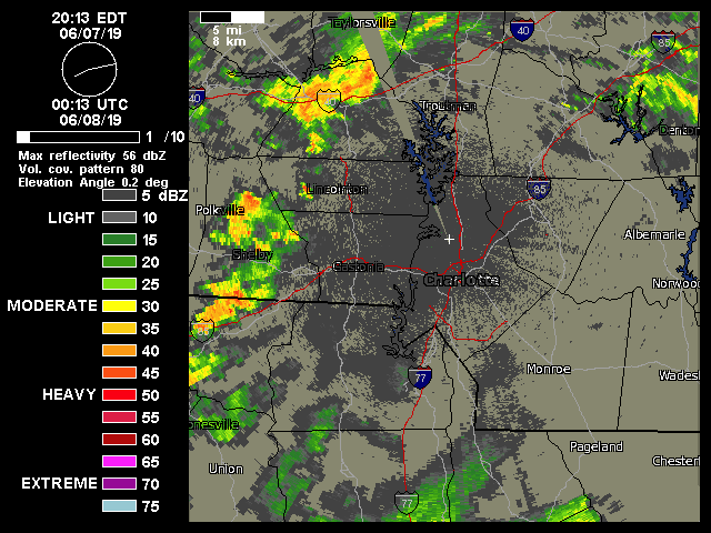
On 12/23/2020 at 6:24 PM, DeltaPilot said:
The last real "free" place with a semi decent Radar picture turned into CRAP! Sending a strongly worded email asap.
https://weather.cod.edu/satrad/nexrad/index.php
^^ For this one you do need to mouse over the topmost icon on the left that is overlaying the map, and click Radar Selection to choose from all of the locations!
College of Dupage's sites thankfully are quite awesome, very configurable too, and very easy to download both animating loops and single images!!
And, available through the second link are the options to show only every x number of frames which can allow a longer time period to view, here is an example!
-
3
-
 1
1
-
-
On 8/11/2020 at 2:05 PM, yotaman said:
I was looking at our extended forecast and it has highs in the low to mid 80's with lows near 70. Nice break from the heat and humidity.
more is on the way!! The image being courtesy of gatorcane from storm2k
-
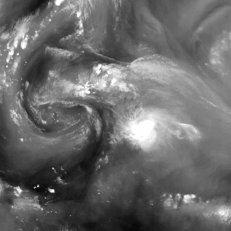

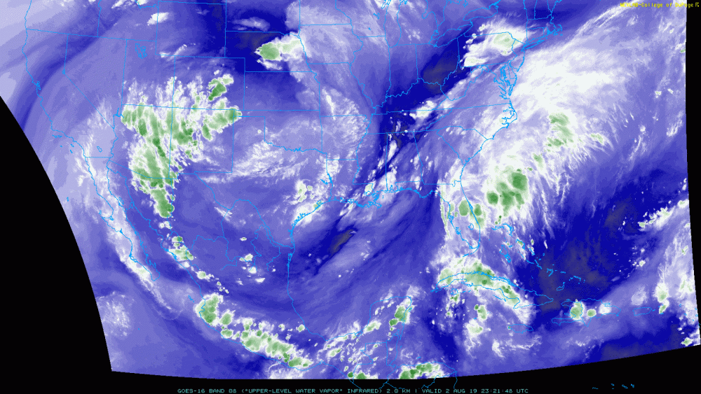
I was reading some posts on storm2k that refer to the large area of convection forming to the east of Isaias and remembered these images i had posted in 2015 of a similar phenomenon happening with ULLs! They are surprised it is as large as the main area of convection of Isaias. In watching the animated infrared and water vapor loops it is interesting that the shape of the storm did develop a more hybrid appearance, maybe it is a specific structure of any type of low pressure based system that results in enhanced convection to the east.
/// Here is what they are saying!
#3586 Postby tarheelprogrammer » Fri Jul 31, 2020 10:44 pm
eastcoastFL wrote:Javlin wrote:hipshot wrote:
Eric, I would still like to know what is the deal with Izzy's evil twin to the east? I appears to have some fierce convection and seems to pulse up and down
in sync on IR with the twin to the west?
That's what I am wondering also?
Ya the thing to the east looks almost identical to Isa On IR
It looks very similar to the blob that hurricane Matthew had attached to it:
-
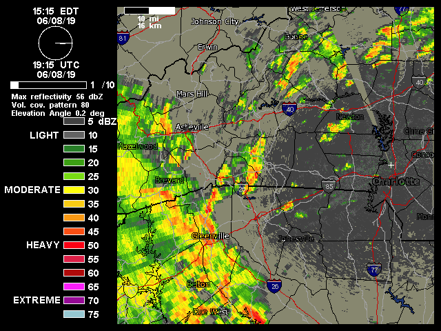
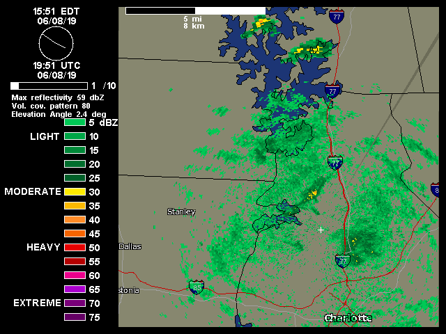
RAH forecast discussion
.NEAR TERM /TODAY THROUGH TONIGHT/...
As of 1130 AM Tuesday...

...The risk for severe storms across central and southern NC later
this afternoon and evening has increased...

There are lots of mesoscale features to note that will all play a
role in today`s convective evolution and thus makes it a complicated
and difficult forecast.

Lead MCV and round 1 of elevated convection has moved off the
southern NC coast with satellite imagery showing an impressive
dry slot immediately behind this feature. Meanwhile, across the
SW Va and NC, a separate upper disturbance interacting with a plume
of deeper moisture is producing an area of showers that will move
east across along the NC-VA border over the next several hours.
This rain will help to lock in a wedge of weak, but cool
high pressure(in-situ CAD) across northern sections of the NC
Piedmont and coastal plain zones. Trailing all these is yet another
MCV approaching the southern NC mtns. While there is very little
wx/rain currently accompanying this feature at the moment, it could
help to spark additional convection across southern portions of the
area later this afternoon, with associated rain-cooled air
potentially helping to stabilize things ahead of the late
afternoon/early evening convection that is expected to develop in
response to the upper trough and associated cold front moving into
the region. Finally, the quasi-stationary front across upstate SC
will be especially important, returning as a warm front into
southern NC, in advance of the trailing cold front that
move east through the area tonight/early Wednesday.

Aside from the batch of showers skirting the far northern counties,
should see a mid day lull in rain/showers, though mostly cloudy skies
will prevail. Will still have to see what becomes of the trailing
MCV coming into the NC mtns, but still expect the emergence of
a new/triple low to develop and ride east along the northward
lifting warm front. Scattered thunderstorms are expected to develop
ahead of the upper trough and cold front and will move west to east
through the area between 21 to 04z. Amidst steep mid-level lapse
rates spreading east into the area, warm moist air advection will
result in 1000 to 1500 J/Kg of elevated instability across southern
and central portions of central NC with the potential to realize
sfc-base instability of 500 to 1000 J/kg across the far southern
zones as the warm front lifts into the area. Given strongly curved
hodographs across the area, this will set the stage for some
embedded supercells to move through the area. If the warm sector
does indeed become established across the far southern zones(this
includes the areas from Wadesboro to Fayetteville to Clinton),
damaging winds, large hail and an isolated tornado will be possible.
Just north of this area, though the storms will likely be elevated,
we could see some large hail, up to baseball size possible. The
greatest threat is between 7 to 11 pm, approximately along and south
of I-40. Convection chances will decrease west to east overnight
with the passage of the cold front. QPF generally 0.25 to 0.50,
locally 1 inch possible.
~~~
GSP discussion
.NEAR TERM /THROUGH TONIGHT/...
As of 1210 PM Tuesday: The latest satellite showed low to mid clouds
gradually filling in from the west with showers and embedded
convection straddling the northern mountains. Trends towards
increased instability and updraft strength and continued likelihood
of an organized squall line this evening supports SPCs extension of
the slight risk of severe thunderstorms to more of the forecast
area. The preferred mode of severe weather may begin with damaging
hail with a few isolated tornadoes as the main threats due to the
more discrete/isolated nature of convection early on and trend
towards more of a wind threat later this evening. This is especially
true along and east of I-77 as most guidance supports upscale growth
of a broken squall line into a full blown mesoscale convective
system. HREF continues to show rotating updrafts which could support
a few tornadoes east of the mountains, however relatively high cloud
bases may limit this potential. Deep moist convection also supports
localized should training of cells occur.
-
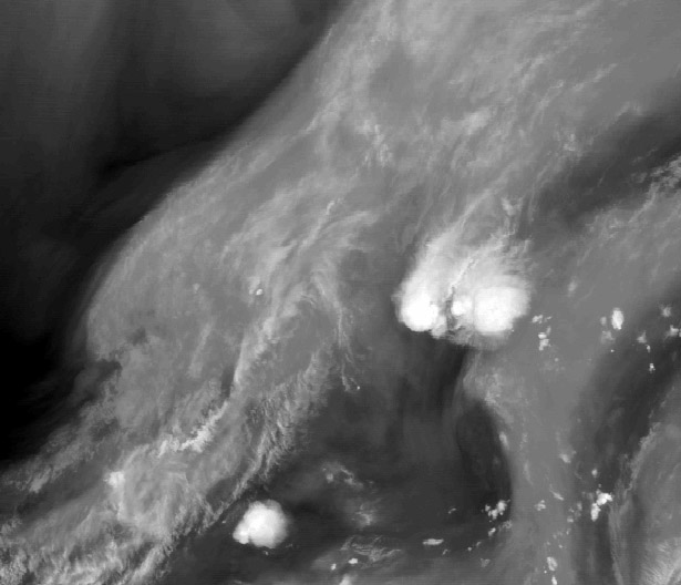
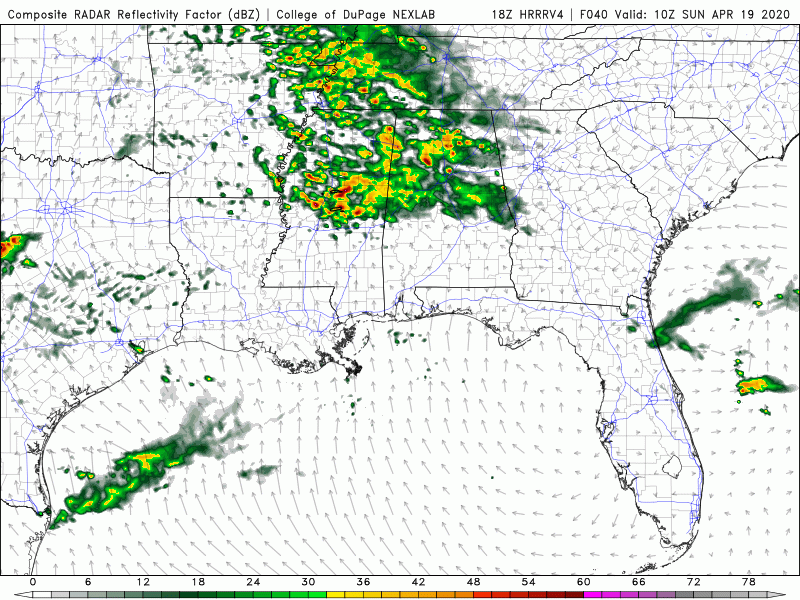
Here are two saved radar loops showing the unique almost-homebrew mesolow feature!!
This one has no frames skipped to see the most recent activity very smoothly:
CODNEXLAB-GOES-East-subregional-Dixie-comp_radar-13_50Z-20200429_map_-100-1n-10-100.gif
And this one is set to display every four frames so that the original MCS can be seen turning into this ongoing small low!!
CODNEXLAB-GOES-East-subregional-Dixie-comp_radar-14_15Z-20200429_map_-100-4n-10-100.gif
Before posting i checked an infrared loop and it is incredible to see, so i will share it as well!
CODNEXLAB-GOES-East-subregional-Dixie-14-14_21Z-20200429_map_-100-4n-10-100.gif
-
.NEAR TERM /THROUGH SUNDAY/...
 As of 145 PM EDT Saturday: Forecast for the near term still
extremely complicated. The first factor of concern is the slight
risk encompassing most of the NC mountains, Upstate SC, and the NC
Piedmont. This still appears to fit well with the area of greatest
severe risk, focusing mainly on the evening hours. With many factors
in play, however, there exists some uncertainty in the most likely
severe threat and exactly where each type of threat will evolve.

A robust upper wave and surface low are in the process of
propagating towards the area this afternoon, with a warm frontal
boundary draped over the Midlands lifting slowly northward towards
the Upstate. We`ve intermittently broken out of cloud cover ahead of
the approaching low today, and with high pressure to our northeast
shifting off the NE coast, the wedge-like pattern that has been in
place for much of today is beginning to erode across the area.
Surface flow has been generally NErly for much of the day, though,
which has limited low-level moistening, and dew points will likely
only be able to peak in the mid 50s later this evening with the
anticipated shift to Srly/SWrly flow over the next hour or so. The
lack of robust surface moisture will likely be a large factor in
limiting surface destabilization, as will the persistent cloud cover
for much of the day.

Despite this, there is no shortage of favorable factors for severe
weather. Deep-layer shear across the area is already on the order of
approx 50kt, and both directional and speed shear (especially in low
levels) will increase through the afternoon as surface flow veers to
S-SWrly. Additionally, a 500mb speed max is on approach towards the
southern Appalachians, and the arrival of an upper jet exit region
will encourage plentiful upper forcing later this evening, close to
00Z. The sharpening upper trough aloft over the southeast will also
decrease temperatures aloft, manifesting in steep mid-level lapse
rates this evening. Despite SBCAPE likely limited to 500-1000 J/kg,
MLCAPE could exceed 1000 J/kg. With the excellent shear and
sufficient CAPE, the mode of convection will likely end up
supercellular, with supercells embedded in a squall line crossing
the northern 2/3 of the forecast area from 23Z-04Z this evening
looking like the most likely final outcome. All severe threats are
in play, though hail rises to the top as the most likely threat with
cool, dry air entering aloft and excellent lapse rates expected. The
potential for wind damage (especially if convection can become at
all linear) and for an isolated tornado (despite the lack of
boundary layer moisture, which keeps LCL heights questionable) is
still in play. It should also be noted that while the best forcing
will be in place across the northern 2/3 of the forecast area and
the greatest severe threat overall is there, the warm front lifting
northward from the Midlands should be watched, especially for
tornado potential as it locally enhances low-level SRH and boundary
layer moisture.

If you`ve made it this far, the good news is that the convection
should clear our area by 05-06Z overnight, though some NW flow and
wrap-around moisture will enhance shower activity in the mountains
near daybreak tomorrow. Some moisture may even break containment,
with showers possible across the majority of the NC mountains
tomorrow, not just the TN/NC border. Though no accums are forecast
at the current time, temperatures will drop enough tomorrow as upper
heights drop that some light snow may be possible at elevations
above 5000ft. the other story across the area will be wind - stout
NW flow will encourage gusts up to 25+ mph outside the mountains,
and up to 35+ mph in the mountains. Temperatures will be below
average.
GSP area forecast discussion is above!
Yes, it is becoming much less vague that there are chances for severe here today. I think that once the beginnings of storms appear on radar there will be discussion happening!
-
1
-
-
On 4/16/2020 at 12:13 PM, Bob's Burgers said:
also, hrrrv4 is back on COD, so get ready for 48 hour HRRR forecasts haha
Here it is so far. I've put it away from immediate viewing in case it is not accurate enough. It looks possible, but definitely an unusual setup.
Here it is so far ^^ I've put it away from immediate viewing in case it is not accurate enough. It looks possible, but definitely an unusual setup.
-
1
-
-
The discussion is like that from GSP as well! It will hopefully not stick with confusing patterns for the models for the remainder of the springtime. Looking at the current overview, the additional layers of complexity are evident!

.LONG TERM /THURSDAY THROUGH SUNDAY/...
As of 306 AM EDT Monday: You would be hard-pressed to find a fcst
with bigger differences between the model guidance out on days
5-7 than what we are presented with this morning. Before we get to
that, we still have decent agreement for Thursday with a cold front
running up against the mtns early in the day, warranting a chance
over the mtns for the first half of the day. The guidance agrees the
front will weaken and cross the rest of the fcst area dry in the
afternoon, but not early enough to keep temps from making it back
into the lower 80s over the Piedmont regions. The cooler air will
finally make it into the region for Friday, with temps returning
to normal, or maybe slightly below normal. From that point onward,
though, the operational models diverge wildly and significantly
as we get into next weekend, with both models sticking to their
guns. In the near corner we have the GFS which has dry sfc high
pressure moving slowly over the southeast and Carolinas with zonal
flow aloft and a srn stream system hanging back over nrn Mexico.
In the far corner we have the ECMWF with a progressive srn stream
system that appears to feed on a tropical connection to develop
widespread heavy rain and possible flash flooding associated with
low pressure moving up the spine of the Appalachians. Wow. Needless
to say, confidence is low. In this situation, we prefer to stick
close to the previous fcst, the guidance from WPC, and the model
blends until a consensus starts to form, so we will keep a chance of
rain with temps near normal, which may seem unpalatable, but right
now there are no good, safe bets. We look forward to a resolution.
-
45 minutes ago, burrel2 said:
Low clouds still haven't lifted here. Satellite presentation is odd to the say the least.
https://www.sendspace.com/file/uc1lhr
Very relaxing and beautiful as well!!
i agree that it is surprisng to see the clouds hold through all of the daylight hours!
-
On 11/1/2014 at 5:23 AM, mackerel_sky said:
Holy sheet! Snow, wind, thunder and lightning!
On Nov 1st ! Amazing!!!
37 degrees!
I was able to find the storm and thread i was remembering!
^^ A radar loop from within the thread that luckily is still online!! It is a very different time of year and different type of system, but it feels similar enough to mention!
-
23 minutes ago, mackerel_sky said:
I cannot tell you the last time any event started as pure snow here!! Honestly 5-10 years?? 2019/2020, just got an A, in my book!
6 minutes ago, mackerel_sky said:Man, it’s beautiful! Mod Snow now, small flakes, but a lot of them!
so very happy for you mack!!!! and everyone else too!!!! It is reminding me of the fantastic and crazy Hallowe'en snow in SC a few years ago!!
-
 2
2
-
-
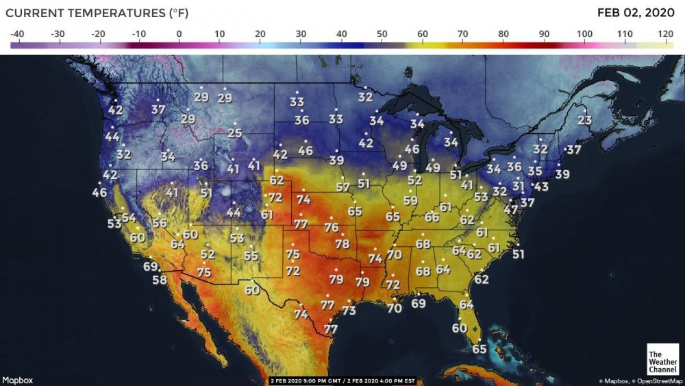
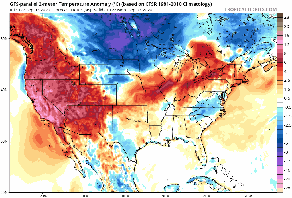
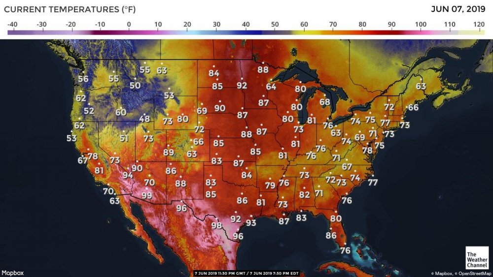
not quite a local observation until tomorrow, but, the reach of the hot temperatures is really surprising to see!
-
I have found out what happened by searching TDWR on twitter! there was a link to this news release from NWS:
weather.gov/media/notification/scn19-82tdwr_terminations.pdf
The TCLT radar was the first to change which made it seem to me as though some kind of a partial outage was happening.
-
I am hoping to find out which websites or phone apps offer reliable access to TDWR imagery!
Being able to see weather as it happens at this resolution really is amazing; I have been using wunderground for many years; as it does offer access, but it is becoming unreliable. What else is out there?? :) :) Thank you so much in advance!!
-
Is there any information available about the downtime of some of the Charlotte TDWR components?
For radar, .60° 250 NMI is still fully in service, but, the other available options display that they have been down since November 19th.
https://www.wunderground.com/radar/us/nc/charlotte/clt
Rainfall accumulation products also seems to have been down since the same time.
I am interpreting it to be the radar hardware itself not transmitting these bands and products perhaps due to updates. Please let me know if this is incorrect, and of any better methods for accessing this TDWR compared to wunderground!!
-
1
-
-
My apologies calculus!! :) I know what you are saying: I think it is because I post so infrequently (a bit over 200 times since 2012) that i can stumble and hedge when trying to describe something that I don't fully comprehend!
In this case I tried to choose my words carefully because I didn't want it to read as though i thought that the forecasts were inadequate! :)
I have found a clearer way to describe the phenomenon since the post which is that Barry and this system, to me resemble the monsoon depressions that occurs in some places globally but are not considered to be an Atlantic phenomenon as of yet.
https://en.wikipedia.org/wiki/Monsoon_trough#Embedded_depressions
-
Yes; it is a rather complex troughing situation, for which the discussions and forecasts have become more abstracted!
The presentation overall is quite amazing to see!
-
1
-
-
1 hour ago, Upstate Tiger said:
Has anyone else had trouble accessing KGSP AFD? It has not been updated since Wednesday evening....
Yes, i saw that: it might be fixed now with the most recent update. What seemed to have happened was that the new updates were accessible through the 2, 3, or 4 clickable number links depending on where they ended up each time, which would normally contain just-prior updates)! It may have been that the Wednesday update was stuck at 1, causing new updates to be placed behind it.
-
This front will actually stall which will be interesting to watch!
Area Forecast Discussion National Weather Service Greenville-Spartanburg SC 1039 PM EDT Mon Jul 29 2019
.SHORT TERM /TUESDAY NIGHT THROUGH THURSDAY/...
As of 200 PM Mon: Return flow around the Bermuda High will
continue thru midweek. Tuesday night a cold front will push
across the Appalachians in conjunction with a well defined upper
trough. This warrants a slower than usual decline in diurnal
convective chances. However it seems the CAM guidance responds to
the relatively high LCLs by depicting little overnight activity. So
even though PoPs were allowed to linger into the night, chances
are not especially high. That trough effectively will remain
in place over the Eastern Seaboard thru the remainder of the
period, maintaining better midlevel lapse rates than we normally
experience this time of year. Likely PoPs result Wed aftn over the
mountains and in a portion of the Piedmont where storms will be
able to propagate. Again Wed night, with MCVs potentially rotating
thru the upper trough, a small nondiurnal PoP is included in the
fcst. Dewpoints recover a little bit Thu compared to Wed, so likely
PoPs result in most areas at peak heating that day. Temps overall
will be seasonable: slightly above normal Wed but near normal Thu
under more cloud cover.Deep layer shear will remain fairly weak despite the trough, so
slow-moving storms producing heavy rain will be possible any time
they develop during the period. Drier air will be present aloft
behind the front on Thursday, with sfc-midlevel delta-theta-e
values becoming supportive of a wet microburst threat.&&
.LONG TERM /THURSDAY NIGHT THROUGH MONDAY/...
As of 155 pm Monday: Starting Thursday evening with the 500mb
pattern showing a trough over the East and a ridge over the Rockies
and western Plains centered over New Mexico. The trough axis
Thursday evening will be from Ohio to Alabama. The axis is forecast
to shift a little east to being over the Appalachian mountains over
the weekend and into early next week. The wind flow is forecast to
be less than 10 knots up to 700mb through the medium range. The
stationary front over our region will continue to slowly dissipate.
A tropical wave that is currently over the eastern Caribbean Sea is
forecast to move to somewhere near Florida over the weekend and
would contribute to the amount of moisture over the Southeast. If
this system were to track more directly over our area, we could get
quite a bit of rain. Too early to say at this point as the system
has not yet formed into an organized low pressure. This extended
period of wet weather could add up to a saturated ground in some
areas. The GFS and ECMWF diverge a bit toward the middle of next
week as the GFS brings a closed low SE toward the Great Lakes. This
would further serve to reinforce the longwave trough. The EC has the
trough lifting some as the western ridge builds a little more east.
Max temperatures will be 3 to 5 degrees below normal due to the
cloud cover and Min Temps will be near normal. -
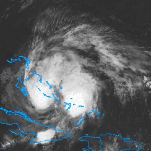
The technology may still be somewhere in the future. Yet: if there was ever a storm system that should be part of modern experiments towards figuring out how to prevent a PTC from stabilizing or to induce weakening at key stages that would thus cause it to dissipate as much as possible, this is it.
Again it is possibly still too early in history, and whichever the coalition of scientists and group efforts would be, they would not want to risk having the opposite effect with their methods.
-
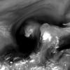
Glad to share a surprising overview, and a close view of a popup riding along!!
-
There is some stalling occurring between waves:
edit: continued radar view
Definitely a unique day temperaturewise! There is a warm front on the move up near the Canada/US border which seems to have a powerful enough effect!


July 2021 Observations
in Southeastern States
Posted
https://imgpile.com/images/NHlX7L.gif
i've finally found a hosting option for downloaded loops from the College of Dupage suite") This depicts the most recent several hours of INVEST 90 (July 2021) The thunderstorms that appear along the far southeast coast were uniquely satisfying to experience in the early morning hours, going in and out of sleep, due to the lightning and thunder off to the east!
This depicts the most recent several hours of INVEST 90 (July 2021) The thunderstorms that appear along the far southeast coast were uniquely satisfying to experience in the early morning hours, going in and out of sleep, due to the lightning and thunder off to the east!