
MNstorms
-
Posts
434 -
Joined
-
Last visited
Content Type
Profiles
Blogs
Forums
American Weather
Media Demo
Store
Gallery
Posts posted by MNstorms
-
-
6 hours ago, OrdIowPitMsp said:
First winter storm warning of the season imby. Going to be sweating the gradient tomorrow, would like to be 30-40 miles south but given the pattern we are in I’ll take it!

You could be getting lucky
.thumb.jpg.205c298b0662a4b78cf55b11a74f311e.jpg)
I haven't gotten over 12'' of snow in a storms since December 2010. Last time I remember southern Minnesota getting over 14'' was May 2013.
-
 1
1
-
-
5 minutes ago, SchaumburgStormer said:
It’s law enforcement confirmed
1 minute ago, andyhb said:Pretty sure that's confirmed...
You mean 8 minutes after he posted this? He said a tornado west of Lake City was going towards town. It didn't touch down until after Lake City. Stupid thing to say it's confirmed when not.
-
4 minutes ago, andyhb said:
Tornado ongoing west of Lake City, IA, heading towards town.
It's not confirmed..
-
On 1/21/2021 at 6:03 PM, Hoosier said:
Anyone think this will verify?

The amazing thing is the GFS has picked this system up from the start and hasn't stopped. I don't know if I've seen that before.

-
1
-
-
One person guessed right in the poll.
-
 1
1
-
-
Everyone here complaining about rain while the GFS has 24'' of snow for me.

-
Lot's of 55-60 mph wind gusts in western Minnesota with heavy snow. Most roads are closed.
-
 1
1
-
-
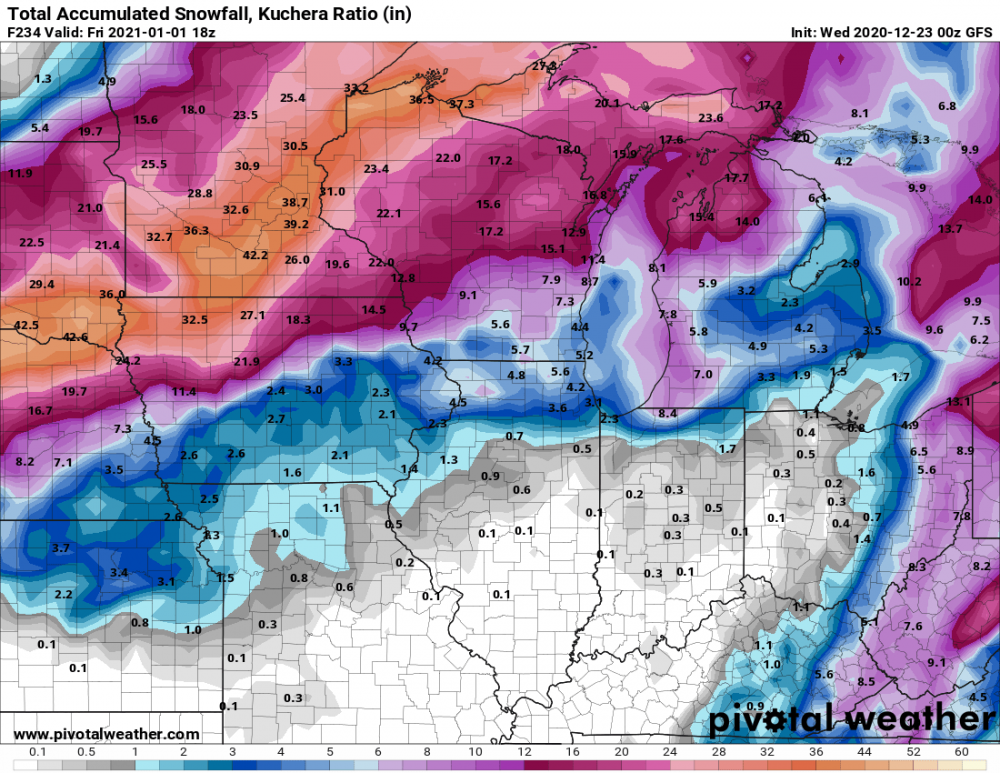
7 hours ago, OrdIowPitMsp said:
Wow trend cannot be denied. Looks like blizzard conditions very well will be imby tomorrow. P&C at 5-9” with gusts to 50mph. Rare full forecasters discussions write up at 8:45pm. Worth the read.
Upped that to 60mph:
Winds pick up mid afternoon and be impressive. Very effective mixing
and an unstable boundary layer could bring 50+kt wind gusts down to
the surface. Forecast soundings from western Minnesota show 60+ kt
winds at the top of the mixed layer, with gusts up to 60 mph
possible in western MN.
-
2
-
-
Well then GFS...
-
 2
2
-
-
How boring...
-
1
-
-
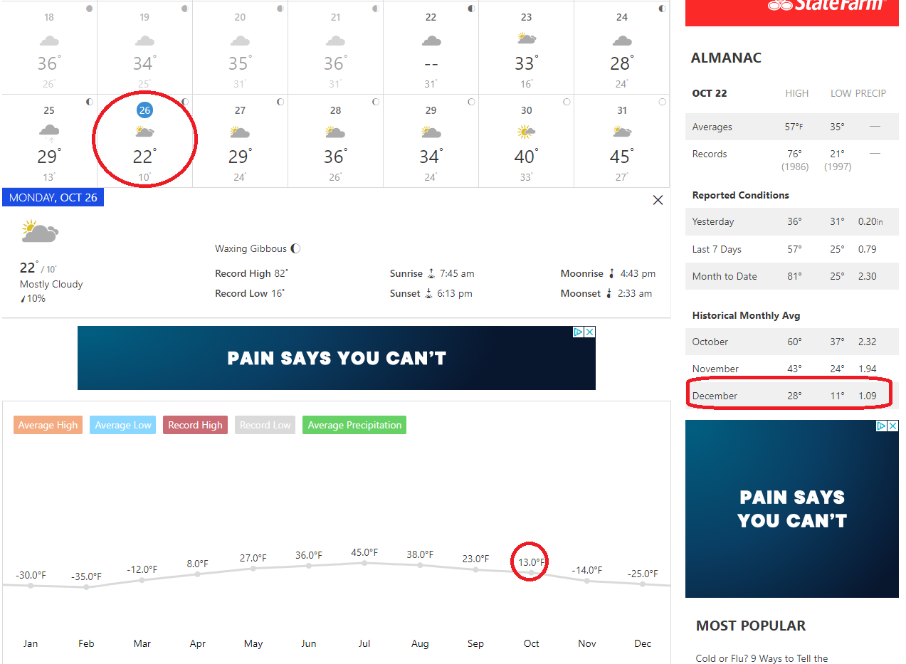
All time October lows may be broken in Minnesota next week with December weather.

-
1
-
1
-
-
6 hours ago, michsnowfreak said:
What a storm for Minneapolis. im a little jealous but not too much, winter is so long and Fall so short. It will be interesting to see how long the snow sticks around as it's so early. We had 0.7" on May 10 that melted in about 3 hours. meanwhile our 9" snowstorm last November 11th didn't fully melt for 11 days, and that was "only" 3 weeks later in the calendar year.
Thankfully the fall colors came early this year and most of the leaves are gone. Already lost a couple inches today with mid 30s and drizzle. Tomorrow looks like heavier rain south of the Twin Cities so there might be a small area that keeps it on the north side.
-
1
-
-
Thursday storm has been trending south. Still rain for me but Twin Cities snow chances increasing.


-
1
-
-
-
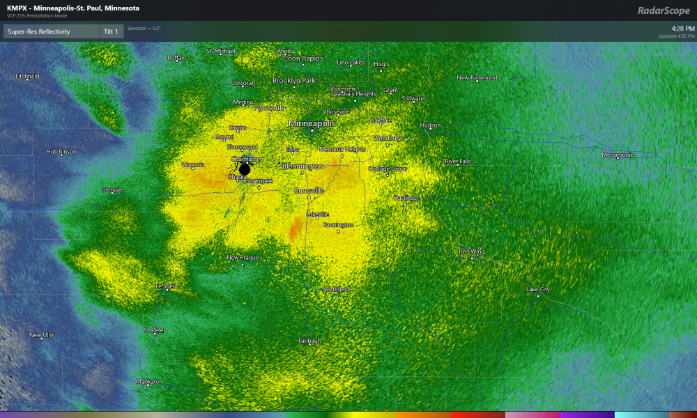
Measured 6.6''' as the snow is coming to an end here.
-
4
-
-
Twin cities getting hammer. I'm south a bit and have about 6''.
-
1
-
-
3 hours ago, OrdIowPitMsp said:
....and just like that Winter Storm Warning for MSP. Wonder how many of those have been issued in October.
Probably once or twice. Looks like they will break the record for largest snowfall this early in the season.
Twin Cities: Largest Daily Snowfall Totals, October Rank Date Amount (inches) 1 October 31, 1991 8.2 2 October 29, 1905 5.5 3 October 20, 1916 3.0 -
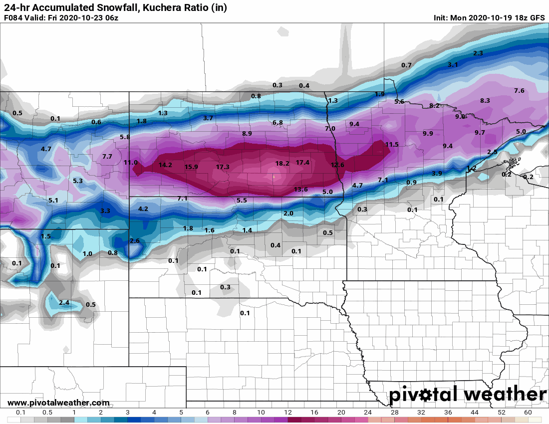
Looks like a snowy end to the month possible in the upper midwest


-
2
-
-
The only Tropical system from the gulf I can find that has impacted Minnesota is Hurricane Alicia in 1983. Sometimes we get remnants from pacific storms.

-
1
-
-
A bit out but the models have snow next Thursday night into Friday here in southern Minnesota. A early winter?

-
1
-
-
Pacific becoming active. GFS has a Fujiwhara effect happening.

-
17 minutes ago, Hoosier said:
Yeah, the bars represent omega. Pretty strong/deep lift at that location at that time. You can get enhanced soundings (wind profiles) that may not be representative of conditions across the area.
Can you post one without so much omega? Would be curious to see how those wind profiles look.
I switched out the sounding in the opening post for you to look at.
-
35 minutes ago, Hoosier said:
Holy convective contamination on that forecast sounding.
Can you explain? Is it the the red bars on the left? There's soundings within a few miles without them but everything else about the same. Some things on soundings I'm still learning about.
-
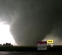
A few active days here late in the season. Mostly wind event but tornadoes are possible. Tomorrow looks interesting imo. Warm sector setup with strong shear.
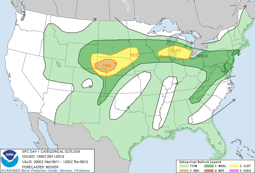
Tomorrow:

Southern MN:


.jpg.35c1e29f039a9da975ce9c3bd3cbc84f.jpg)


December 10-11 Winter Storm
in Lakes/Ohio Valley
Posted
Largest snowfall that season for me was 9.8''.