

BeauDodson
-
Posts
417 -
Joined
-
Last visited
Content Type
Profiles
Blogs
Forums
American Weather
Media Demo
Store
Gallery
Posts posted by BeauDodson
-
-
I'm pretty sure Mike and the media were confused. There were two different storms issued for separately. I suspose it was unfortunate they were in close proximity to each other spatially and temporally. But nonetheless, there were separate defining warnings for each storm
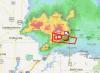
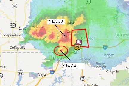
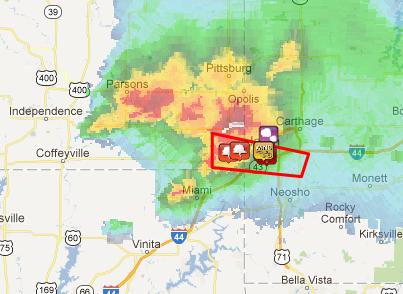
At 509 LT, a warning (VTEC 30) went out for the nrn storm, while the Joplin storm (VTEC 31) was still developing on the SW flank.
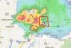
At 517 LT, the warning (VTEC 31) went out for the Joplin storm.
Yes, I remember that during the event - we were discussing it in the forums. I think a lot of people among our group realized the risk for confusion was high. Thus the nature of multiple tornado warnings.
I think some in the media were caught off-guard by the extreme nature of the tornado - as mentioned also on WeatherBrains the other week. Developed fast - grew in size and intensity fast - sirens sounded county wide for the first storm - confusion over the second storm - media focused on storm A instead of A and B. It was an episode of "It Could Happen Tomorrow"
-
On page 23 of the book - Mike says -
Begin - from the book:
At 5:39, even though the tornado was on Joplin's doorstep, the NWS wrote, "At 5:34 p.m., trained weather spotters reported a tornado near Galena (emphasis added by Mike in the book)...moving east at 25 mph. This storm is moving into the city of Joplin." Although Galena was old news, the statement "this storm is moving into the city of Joplin" was correct. But, by saying "near Galena" they misled people in west Joplin into thinking they had more time than they actually had.
Unfortunately, just three minutes later, the NWS contradicted its own statement with a confusing and factually inaccurate "severe weather statement," in which I've emphasized a crucial two words:
At 5:38 p.m., trained spotters reported a tornado near Joplin or 6 miles northeast of Galena, moving northeast at 45 mph:
End of passage from the book.
------
That is exactly what he said - the above - from the book.
He says the media was then further confused and were visibly confused on air. He also says that local residents said the NWS kept saying Galena and they thought they were out of danger in Joplin. This is what Mike is saying in his book.
He also says that radio stations were repeating what the NWS was saying - confusing people further.
Bottom line is that the book states people were very confused by the NWS.
Again - I am just telling you what the book says and these are not my opinions. To be clear.
 The book repeatedly says that their private service was accurate and that the NWS was inaccurate. It is the most severe and critical criticism of the NWS that I have ever seen in print.
 -
The spotter reported it 6 miles NE of Galena moving NE at 45 mph at 5:38 LT.
The the first issuance of the Joplin tor was based on radar at 5:17 LT.
According to the book it was not corrected - that they did issue a new statement but continued to center in on the Galena storm/location.
And to be clear - I don't know the facts - just telling you what the book says.
-
The book goes into complete detail as to who made the reports and how the reports were either ignored or misrepresented in future warning/statements.
The book did raise one question - which is significant. Does the NWS have a problem with their pathcast system/algorithm? I noticed my local office issued a warning earlier this year and said a storm was moving northeast. The storm was actually moving east. I pointed this out to them and their response was along the lines of "oh that is probably just a product of the computer software"
Hmmm - is this a problem? Mike raises the question in the book. I have no idea if this is a bigger problem (as he mentions) or if he is incorrect. It did make me remember the incident earlier this year in my local region. If it is a problem then it is a fairly serious issue. If media is telling people a storm is moving northeast and the storm is actually moving east then that is a problem.
Of course anyone with any radar skills can determine for themselves what direction a storm is moving (talking about on-air mets here). However - should on-air mets be telling people something different from the NWS (and in the heat of battle would they even notice - or would they trust the NWS)? Obviously I already know the correct answer to the question.
-
Wow - just Read Mike Smith's new book about the Joplin, MO tornado. A damninnnnnnnnngggggg assessment against the Springfield, MO NWS. I don't think it could have been any more stinging than what is written in that book. Ouch.
Has anyone else read the new book? Took me about an hour to read it - was surprised to see just how sharp the negative comments were towards the NWS.
The book made a lot of mention that the NWS got the path-cast wrong - on more than one occasion/statement. Also mentions that their private service was more accurate.
-
Thanks for all of the updates from Joplin - just catching up on the thread. Glad the city is recovering - slowly but surely. It will take a long time to get over 2011 - for many parts of the nation.
Devastating tornado strikes Joplin, Missouri
in Weather Forecasting and Discussion
Posted
I think there is the issue - brought up in the book.
That does not mesh.
If the tornado was 6 miles northeast of Galena and moving northeast then the tornado would not have hit Joplin or at least southern Joplin. On that track it would have taken the tornado north of Joplin - or most of Joplin.
This raises the question - was it a mistake? Were they playing the odds on where the tornado was located based on radar and conflicting other reports? The storm evolved so fast that they did not know what was going on? They had spotter reports indicating a tornado in an area that their radar wasn't even showing the tornado - yet?
I don't know what was going on.
If spotters reported the tornado near Joplin - did the NWS believe them on the location? Did someone assume that the spotter was wrong and the tornado was actually further north (or according to that statement - 6 miles northeast of Galena)