

BeauDodson
-
Posts
417 -
Joined
-
Last visited
Content Type
Profiles
Blogs
Forums
American Weather
Media Demo
Store
Gallery
Posts posted by BeauDodson
-
-
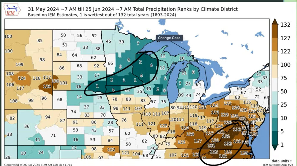
You can see where the ridge set up shop over the last three weeks. The haves and have-nots. Too much rain and too little rain.
-
 1
1
-
-
Our long-range team has a great video today about July's weather. A bit of a nail-biter for the Ohio Valley. We will have to see where the ridge sets up.
Would not be surprised to see the MCS train produce pockets of ten or more inches of rain.
These videos can be viewed on our www.weathertalk.com app. If you don't live in our area, then choose any given county and then download the app to view the daily videos.-
 3
3
-
-
It appears the GOV is closing most roads at 4 PM. That shuts me out. Disappointed, but it is what it is. I have to be at NWS conference this morning. Otherwise, I would have left last night.
Be careful, everyone. Enjoy the white gold. Looking forward to the photos and videos.
-
1 hour ago, BuffaloWeather said:
Everyone likes the discord more than here. Might just be me posting on here for this storm. I love to look back at all the pics/videos years from now.
What Discord room is that? Thanks
-
Hoping I can come in from the south tomorrow afternoon.
Sounds like they will close it.
Unsure another way in.
-
11 minutes ago, LansingWeather said:
Im actually flying up for this storm, going to be my first of these storms, Ive chased a lot of events in SWMI. Im going to be staying at the regency so if anyone else is going to be around feel free to DM me. Hopefully the band comes right in over my hotel and not just south lol.
What are you driving once there?
-
Interesting setup for LES. I remember the 2000 event. Incredible totals.
Quite a bit of thundersnow.
I'm thinking about chasing this one.
-
6
-
-
Is this the correct thread for the Buffalo area?
Thanks
-
4
-
-
On 5/22/2021 at 12:59 AM, JoMo said:
Today marks ten years since the tornado. I'll never forget the sound (the roaring tornado, the constant ambulance sirens), sight (everything looking like a giant landfill, being able to see from one end of the city to the other end due to the lack of trees), and smells (first freshly cut wood and then natural gas) of that day, and the resultant days after that when so many people came to help. I'll never forget seeing the good side of humanity, people working together, people looking out for their neighbors, and the will and determination to move forward and rebuild. I'll never forget seeing the bad side of humanity as well, the out of town looters, and the "master" development firm that the city hired to rebuild that delivered pretty much nothing.
Joplin's population has pretty much stayed the same around 50,000 as it has for many years before and after the tornado. The housing stock has been replenished and in some places even exceeds what was there before. A developer that formed after the tornado has packed houses in pretty tightly in some places. That might not be a good thing when it comes to future storms. Only two families out of the original 7 still live in their Extreme Makeover Home Edition houses. Some moved to bigger houses, some moved away, and some didn't like being a tourist attraction and just wanted peace and quiet.
Hi JoMo,
I thought about you on the anniversary of the tornado. It is hard to believe that it has been ten years. It seems like yesterday.
I don't come on the forums very often, but was browsing it this morning and noticed this thread was still active.
I hope you are doing well. I can't imagine the amount of trauma associated with an event like this. I can only compare it to what I saw after Katrina and Rita.
It is hard to fathom so much destruction and loss of life.
-
1
-
-
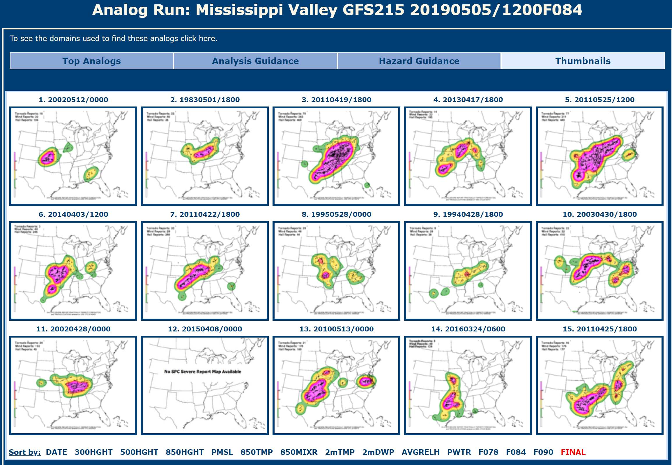
CIPS analogs are showing some decent events. http://www.eas.slu.edu/CIPS/ANALOG/DFHR.php?reg=MV&fhr=F084&rundt=2019050512&map=thbPPF
This is the near perfect forecast graphic set.
Wednesday and Thursday have some potential but, as always, is highly dependent on what happens with the dying MCS's.
So far this year, our region has had numerous conditional events. Meaning, the forecast has been low confidence because of ongoing rain and clouds.
The two tornado events were poorly forecast. One tornado event did not have a watch and was in the general thunderstorm forecast zone.
Our last tornado event was on May 2nd. That was under-forecast, as well.
It will be interesting to see if we can pull off a region-wide event this week. Most of the events have been localized, thus far.

-
2
-
1
-
-
Love your site.
-
It's hard to believe we are coming up on 5 years since the tornado. I still remember it like it was yesterday.
It looks like Joplin is planning a Disaster Recovery Summit on Thursday, May 19th and Friday May 20th.
Speakers will come from Greensburg, KS, Tuscaloosa, AL, Cedar Rapids, IA, Minot, ND, Moore, OK, Vilonia, AR, Pilger, NE. There's various breakout sessions covering disaster related topics.
Full agenda: http://www.joplinproud.com/joplin-disaster-recovery-summit/agenda/
Joplin Memorial Marathon is on the 21st.... A community picnic will be held Sunday the 22nd, along with Joplin High School graduation (creepy that it's on Sunday the 22nd, just like the tornado) and it'll all end with a Memorial Service for those lost in the tornado.
Was thinking about you today. Popped into the forum to see if this thread was still alive and well. I see that it is.
I agree, it is hard to believe that it has been five years. Hope you are doing well.
-
Weather Brains had an interesting guest on recently. Dr. Jason Persoff. He recounted his experience in Joplin immediately after the tornado struck the city.
-
I've long since given up on the NWS path-cast system.. the storm vectors that are included in the warnings are almost always awful and a lot of the time the projected paths aren't very accurate. Really, do we need to rely on computer algorithms for this? I'm an on-air met and I have no trouble saying something different from the NWS if I know the NWS info is wrong and mine is right. It's our job to tell the public what's going to happen, not to tell the public what the NWS says is going to happen.
I agree 100%.
I have caught errors on this subject more than once. It is a concern. I am going to bring it up again with our local office. Especially after the answer I was given earlier this year.
-
Would you go as far as to say the recommendations in the service assessment are not valid then?
Although I can't answer for him
I find the service assessments extremely valuable. I read them all - have them all printed out - keep them here on hand for review. I think the NWS, emergency management, media, and others read them - utilize them - take them for what they are. I learn something from each assessment and make changes accordingly. From talking with others - they do the same.
The process isn't perfect - it is evolving - will continue to evolve. The more we learn - the more we realize we have a lot to learn.
-
Unfortunately this book is being sold in many outlets - to the public. I am not sure how someone outside of the meteorological community would view this. It makes the NWS look incompetent.
I do agree with Mike on some of the topics brought up within the book. Some of them are the same concerns raised in the service assessments. Of course service assessments are not read by the general public.
If this publication was for internal purposes then I would view it as a severe lashing against the NWS, some in the media (although they are excused somewhat in the book because they were parroting what the NWS said), and emergency management officials who didn't blow the sirens properly.
For a publication like this to be sold to the public - not sure it is helpful or useful. It does strongly promote their private warning service. I am not sure how many times their private warning service was mentioned - but several times. Emphasis was added that they got the track right and the NWS got the track wrong.
Critique is important within the weather community - there are several private and semi-private forms to do just that. Critique can be important in moving everyone forward - improving products issued for the public - improving siren policies - other. However, I would agree with some others with the same sentiment that the book is a bit disappointing in the approach. When one group/agency makes another group/agency look like fools - with little mercy - then eyebrows are raised that there is some sort of agenda at hand. I am afraid this is what the book left me wondering.
The book raises some important points - valid concerns - items of interest. The approach, though, was disappointing. The NWS had a very difficult job that day - emergency management had a very difficult job that day - the manner in which the storm formed, exploded, evolved made for a perfect storm of sorts. Unfortunate and so was the outcome.
-
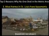
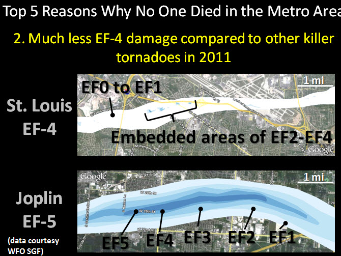
I think that one had a very limited area of EF4 damage. I want to say only one structure but not sure.
It was a very small area with EF4 damage.
-
The inability for humans to accept that, sometimes, life sucks and **** happens is at play more in this case than any other I can remember.
If is funny you should say that - because

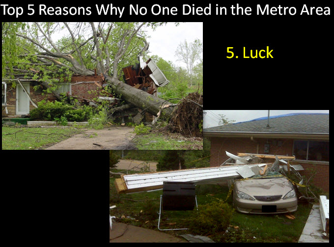
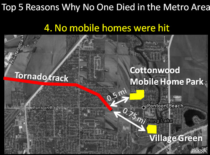
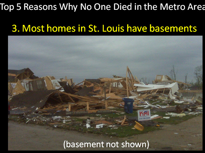
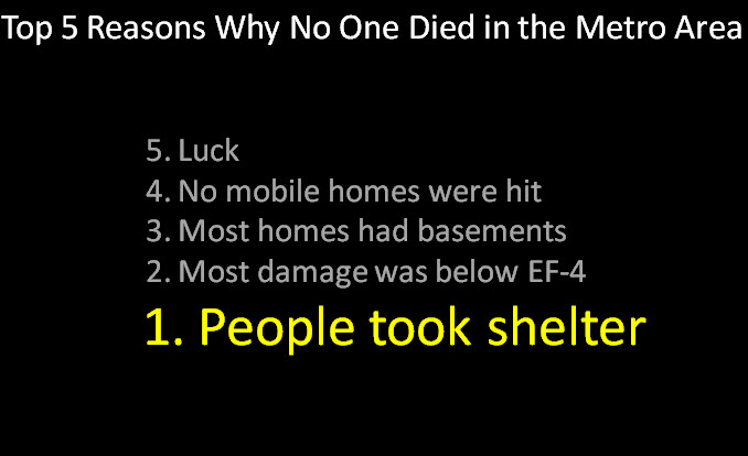
One of the NWS meteorologists, from the St Louis, Missouri - National Weather Service Office, did a presentation (last fall - at the big NWA conference) in Birmingham, Alabama on their EF4 tornado event. She said that the reasons there were not more fatalities in the EF4 St Louis tornado was - wait for it and drum roll - LUCK
She had a list - but LUCK was, if I remember correctly, number 5 on the list.
This is what was on her slide presentation
-
Re: the whole issue with Galena. From what I've read, it takes a few minutes to generate a warning. The forecasters were probably still writing the warning when the 5:38 scan came out. Notice that there were only three minutes between the 2nd (5:39) and 3rd (5:42) SVS's. This may be due to the fact that the forecasters noticed that the couplet was closer to Joplin than it was to Galena. I think the important part is that the 5:39 SVS mentions the tornado is moving into Joplin. That should be enough to sound any on-air met's alarms. Furthermore, on-air mets should check the radars themselves and know what's going on. I haven't read the book, but again the title of it implies the warning system failed, which, IMO, it did not.
There was not a single tornado emergency issued -- the SVS's I posted were all the ones associated with Tornado Warning #31.
I think, in general, the timescales associated with this particular event (i.e. the time of evolution from doppler-warned to confirmed to particularly dangerous tornado) were much shorter than average, shorter than the radar period or warning-writing timescale.
I am not sure a tornado emergency would have mattered. Maybe for the on-air people? Unsure. We will never know.
Of course now we have the new warning system = Springfield is one of the offices using the new terminology that attempts to predict how much damage a tornado will or won't do. It would not have mattered in this event. It was too late - not to mention that I don't think hey had enough time.
I have seen some meteorologists that focus on "their idea" of where a storm should track and if radar is showing something different they still seem to not catch on. In school this is called tunnel-vision. I said it must be going northeast and it must be heading to town A B and C. By the time you realize it isn't happening as you expected then it is too late. Not saying that is what happened here - but the evidence stacked up by Mike in his book does suggest that concept. At least as a potential.
It is too bad there was such a delay in the tilt scans. Had they had the phased array radar then this would have likely ended a lot differently. This is where local radars - owned by television stations - can be of some value. It is too bad the NWS can't zero in on a storm and get faster updates.
-
Yeah I noticed that in that video and thought it was a bit of a fail on their part, and they also seemed to not be urgent enough regarding the wording initially about what was/is obviously a huge wedge on the ground...
Mike brings up that subject, as well.
-
Not sure the DOC allows me to post the logs - I have them. Just not sure if I can post them or not? They are interesting because they show a lot of communication about what is happening to the City of Joplin and before Joplin. From the logs there appears to a lot less confusion as to what is/was going on - at least when you compare then to the statements that were actually put out by the NWS for the public.
-
I doubt that's it. It's hard to go against 200 kt couplet with debris ball. My thinking is the forecaster put the location as "Joplin" in AWIPS, which spat out an alternate location of "6 NE Galena". The Downtown Joplin *dot* is in fact north and east of the central Galena *dot*, and that's all that AWIPS has. In the whole confusion during that time, and dealing with multiple TORs in close proximity, the forecaster(s) may have not paid as much attention to that error, or they may have felt it would take to long to correct, given the urgency of the situation.
This is a problem. I hope this issue has been addressed within the NWS. I am a bit alarmed by the incident a few weeks ago in my local area - afternoon reading your comments and this book. If a computer is spitting out these names and errors and the NWS isn't "catching it" - then we have a problem.
I don't know if this is a bigger issue or not. It is a question worth discussing. Surely the NWS can correct the storm movement based on what they were seeing. Or - perhaps in this case - it was simply just a bad error.
-
My take on this.
1) SW side of Joplin/Iron Gates had had minimum 15-20 min lead time, using the 5:38 PM radar image posted above and the fact the relevant TOR was issued at 5:17.
2) The first relevant TOR indicated that the storm was moving NE, which was ultimately incorrect, however while the storm was still in its fledgling stage this may have been a valid extrapolation of the motion. In their formation stages, supercells often move with the mean wind at a rapid clip, before sharply turning right and slowing down as the updraft matures (but not always!). So, until we are more sure with our science, and given the software that's in use, extrapolated motion's the best we got. Of course everything is clearer in hindsight.
3) The SVS's correct the initial TORs and give a correct heading -- except for the last one.
3) The cities impacted -- Iron Gates, Joplin, and Duquesne, are mentioned in every SVS as well as the initial relevant TOR -- except for the last one WRT Duquesne.
4) I agree that there is this (dare I say it?) --myth-- about the tornado forming right over town. There was a good chunk of time between spotter confirmation and tornado doing damage in Joplin. I think by the second SVS, a tornado emergency may have been justified, given the confirmation and the statement that the tornado was in fact moving straight into town.
So the only thing I would have a beef with is SGF's 5:42 SVS, but by then the tornado was over the city and doing damage so it doesn't really matter as much. I also agree that the proximity of the two TORs may have confused media. Many things could've been done better, but the warning system hardly 'failed' Joplin.
I don't disagree with your assessment after the fact. My concern is that people were not reading the warnings. Who do we know that reads tornado warnings? They were likely going on what the on-air people were saying (and according to Mikes book) the radar stations were telling them. They were not telling them that they were in danger.
It is obvious - after seeing the warnings/svs - that there was a lot of confusion. Mike is likely correct on that subject. I think there may have been more confusion than some of us from outside the region realize. This is because of the on-air meteorologists and radio broadcasters reading the warnings and not checking their own radars for verification of what the NWS was saying.
Mike even goes as far to say that the on-air mets didn't even realize they were looking at a tornado on their tower cam - they thought some of the power flashes were lightning. It wasn't until it was too late that they realized they were looking at a very large tornado hitting their city.
Was a tornado emergency issued? I don't remember. I remember being in chat that day and telling them that there was a lot of damage being reported - also reported some baseball size hail. Mike says - implies or says - that hail was never a concern and that baseball size hail never occurred.
I remember making a report to their office of baseball size hail somewhere north of Jomo. Do not remember exactly where - but it the report was made. Of course nobody cared about the hail at that point - it was too late.
Mike also has some eye witness accounts that told him they felt the main concern for Joplin was hail and this was based on what the media was saying.
I should pull up the logs from that day and see what was being said in the room.
-
Yep, that was the mistake. The tornado was not 6 miles NE of Galena and it was not moving NE at 45. The area was in the polygon either way, just the SVS statement was incorrect. I think the next tornado warning was issued at 5:48.
And this is apparently where the confusion was - on-air mets and radio rip and read were telling people the wrong area.
I guess the next question is how many residents heard the wrong information and thought "that is not near me - I am safe"
We will never know. According to the book some people interviewed said they kept talking about Galena and they felt safe in southern Joplin.
Someone with a radar should have caught the mistake. Private meteorologists - on-air television meteorologists - others. We knew this was an error on the forum - or we at least knew Joplin was in serious trouble. Why didn't others know this? Was it because they were too busy covering the storm - weekend - not enough staff?
Had this been in Oklahoma City then I can almost guarantee you that the on-air mets would have caught it. They have their own radars - they would have been able to see that the storm was forming and moving east into the part of Joplin that was hit.
Do any stations in the Joplin region have their own radar equipment - Barron or other?

Summer 2024 Medium/Long Range Discussion
in Lakes/Ohio Valley
Posted
They batted about 80% last year with long-range outlooks. They have come a long way since their infancy years ago. Their farm and garden videos, GFS analysis, and EC analysis videos are excellent. They have an amazing team of meteorologists.
Years ago, I felt the same way. But, over time, they have become a great company!