

weatherguysc
-
Posts
105 -
Joined
-
Last visited
Content Type
Profiles
Blogs
Forums
American Weather
Media Demo
Store
Gallery
Posts posted by weatherguysc
-
-
-
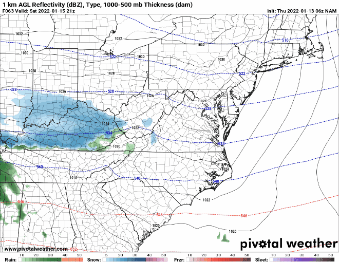
6Z NAM 63-84
-
 1
1
-
-
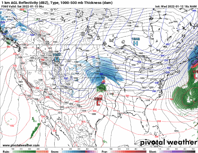
18z NAM 60-84 has the low almost in the Florida panhandle at 84
-
1
-
 1
1
-
-
12z NAM 60-84
-
2
-
-
Anybody know the exact blend of models that are used for this on pivotal?
-
2
-
-
1 minute ago, SnowGoose69 said:
That evolution is more realistic if you ask me
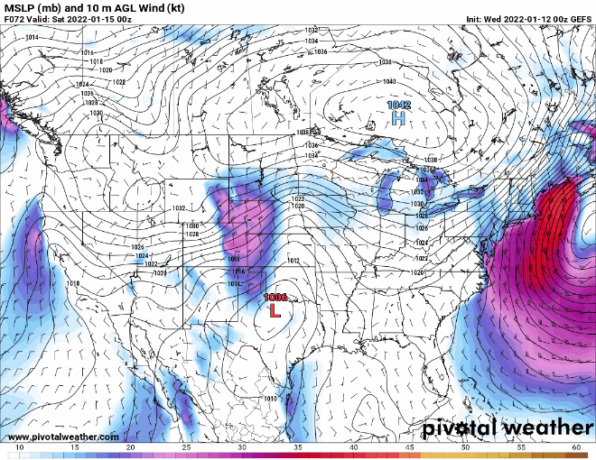
The GEFS has showed it exiting southern Georgia since 6Z yesterday. It has been fairly consistent thus far.
-
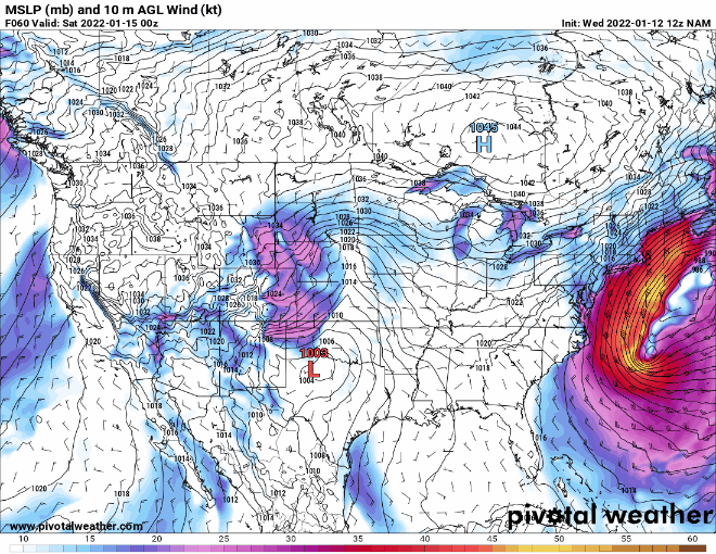
6Z GEFS

-
2
-
-
6Z GEFS has the low exiting southern Georgia and hugging the SC coast.
-
1 minute ago, 85snowline said:
This will NOT verify.
I sure hope not. I'm beginning to wonder if the 6Z got a bad data ingest because of how crazy the low moved around.
-
Lights out for weeks/months for the upstate of SC if that comes true.
-
 1
1
-
-
6Z GFS Hrs 84-114
-
I don't know if anybody posted the GSP long term discussion from this afternoon based on the 12z products. We'll see what they have to say on the next round of updates at 4:30a or so.
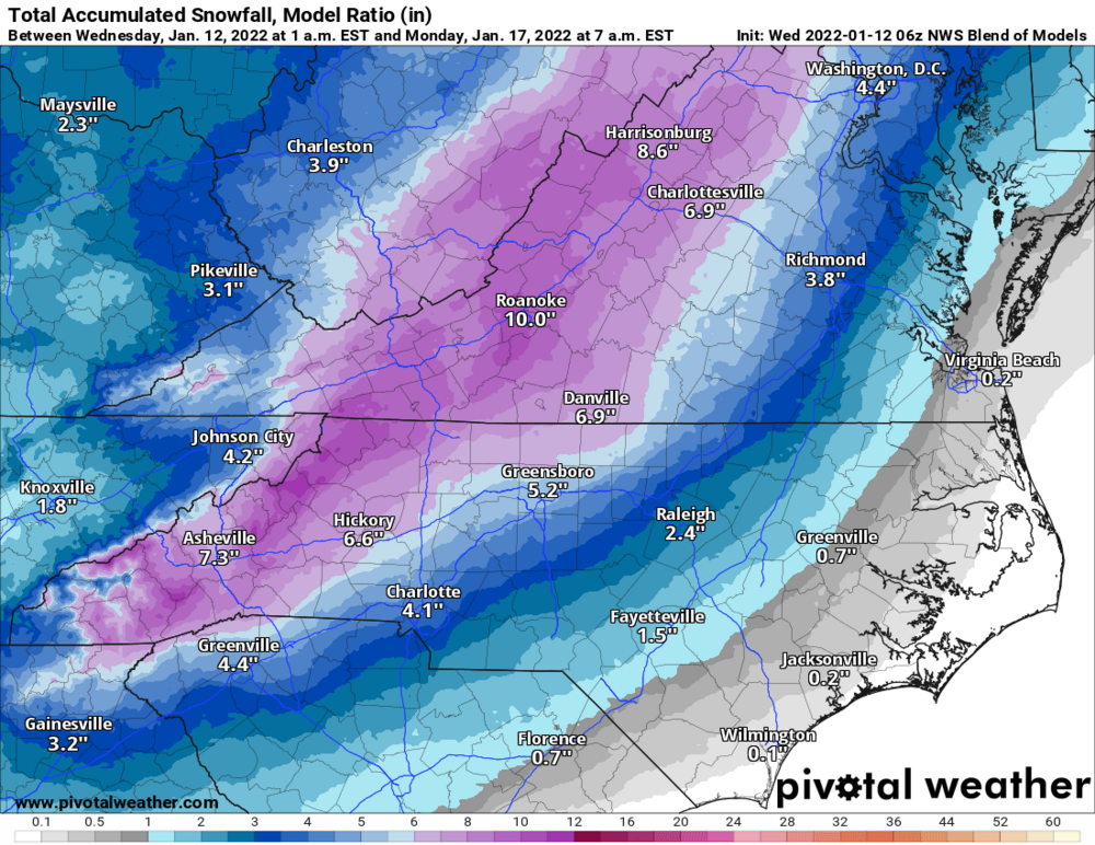
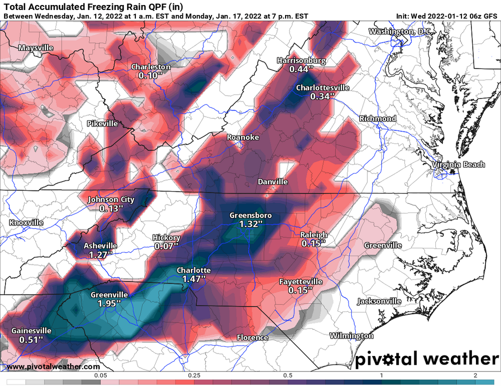
Quote.LONG TERM /SATURDAY THROUGH TUESDAY/... As of 240 pm EST Tuesday: Looking ahead to the weekend, all attention turns toward the possibility of a winter storm that would affect the western Carolinas and northeast Georgia beginning perhaps as early as Saturday afternoon and possibly continuing through the better part of Sunday...emphasis on the word "possible". It is worth noting that the 12Z ECMWF has come around to the GFS idea that a strong short wave dropping southeastward along the High Plains would ultimately cut off an upper low over the central/srn Plains Friday night into Saturday. Also worth noting is the relative run-to-run consistency seen in the operational GFS with this feature. The setup begins Friday night into Saturday as the developing split in the flow helps to slow the progress of a large continental sfc high moving from Ontario, down across the lower lakes, to Upstate NY/New England Saturday/Saturday night. This would provide the necessary source for cold air prior to the arrival of the precip associated with the upper low, which operational guidance suggests will come across the lower MS Valley region Saturday night. The operational models show partial thickness values low enough to support at least a mix with wintry precip as we acquire isentropic lift on Saturday that could force the development of said precip by the afternoon. If this develops as it could, essentially as an activating warm front, it would help to lock in the cooler sfc temps before the main mid/upper forcing arrives from the west. The operational models all show a closed upper low rolling east on Sunday, moving overhead or to the south of the fcst area, then offshore/northeast on Sunday night. Be that as it may, this is not the only possible solution, and some of the ensemble members show very different outcomes to the upper/sfc pattern. Looking at the GEFS...there has been a definite trend toward more wintry precip across more of the fcst area, with the majority of ensemble members at 12Z showing wintry precip affecting nearly the entire fcst area Saturday night/Sunday. The plume diagrams, and their supposed total snow accumulations, appear most tantalizing. However, there are as many ensemble members showing minimal wintry precip as there are showing a great deal, and some still showing none at all. Our forecast will reflect developing confidence in the wintry scenario but limits the precip probs to the chance range for the time being. The trend is toward more of a snow possibility along/north of I-85 and more mixing/changing to sleet/freezing rain south of I-85, but this is only one scenario. The track of the low will determine how strong of a warm nose might develop from the south, which would greatly affect the precip-type distribution. The QPF blend right now is especially modest, and the conservative approach is preferable for a system that is still out on Day 4/5. In spite of the trend, readers are cautioned to manage their expectations...at least for the time being. Stay tuned. If this system develops as it could, we would be in for some NW flow snow on the TN border Sunday night into Monday, otherwise the remainder of the period would be quiet with a large sfc high settling across the region Monday into Tuesday.
-
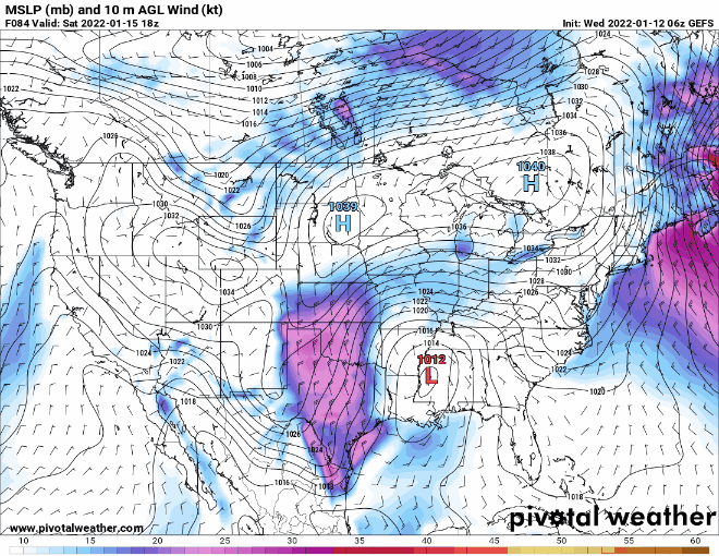
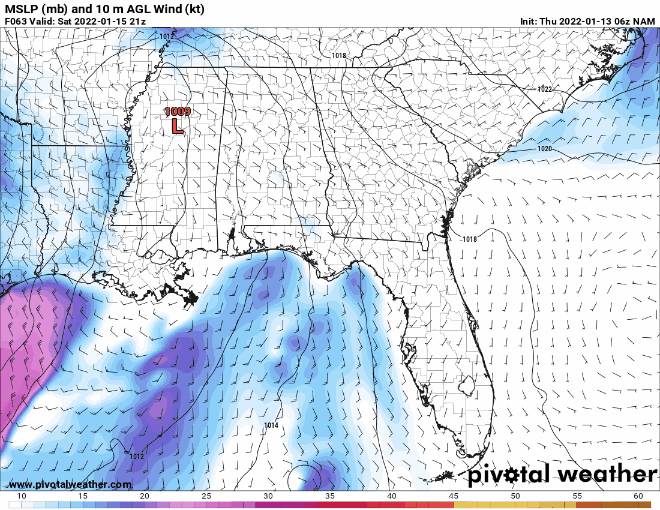
The low tracks across southern Georgia and off the coast of SC on the GEFS which appears to be quite further south than the GDPS.
-
1
-
-
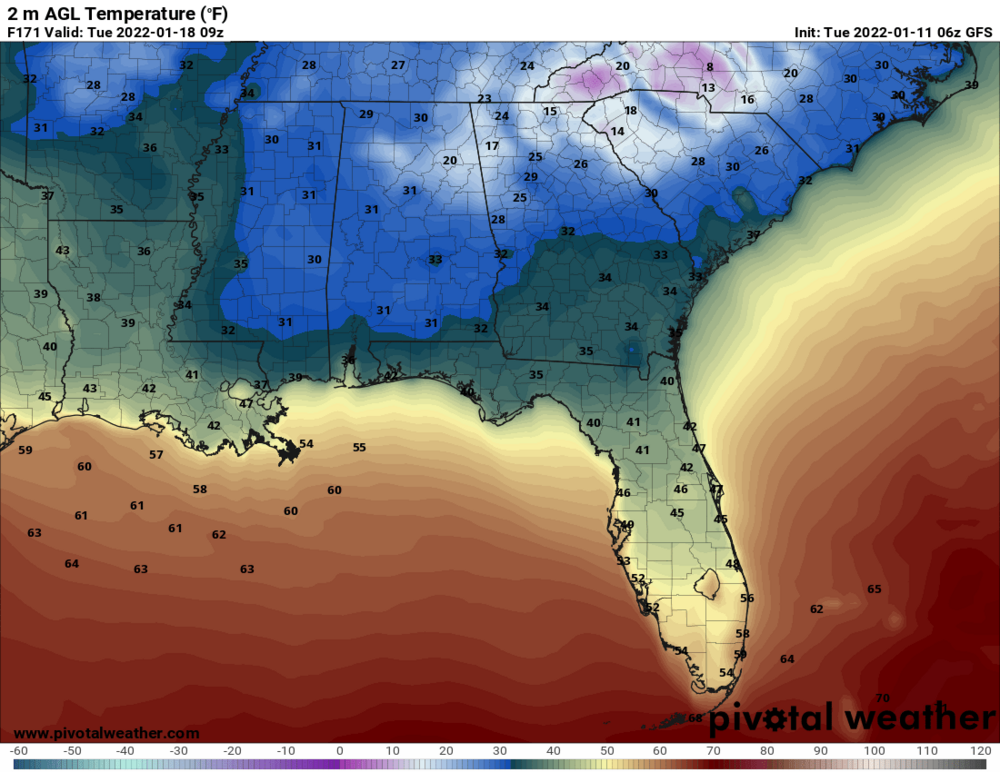
Temps at 4am Tuesday morning...That's cold.
-
2
-
-
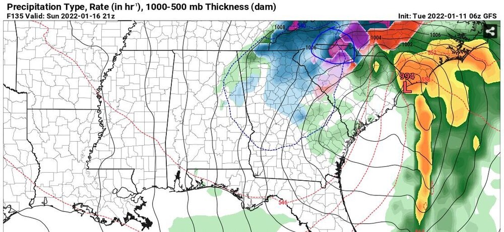
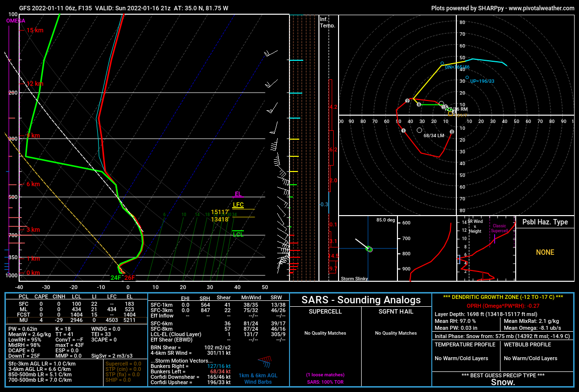
Correct me if I'm wrong, but the blue circle I drew around the dark pink snow...is that thundersnow?

-
3 minutes ago, burgertime said:
@135 BOOM! SE plastard! Total snowgasm. This is gonna be an epic run. Let's all pray its the one lol.

-
2
-
-
GSP's long term discussion from this morning.
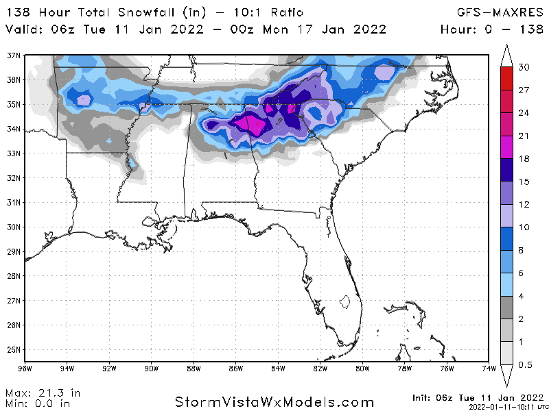
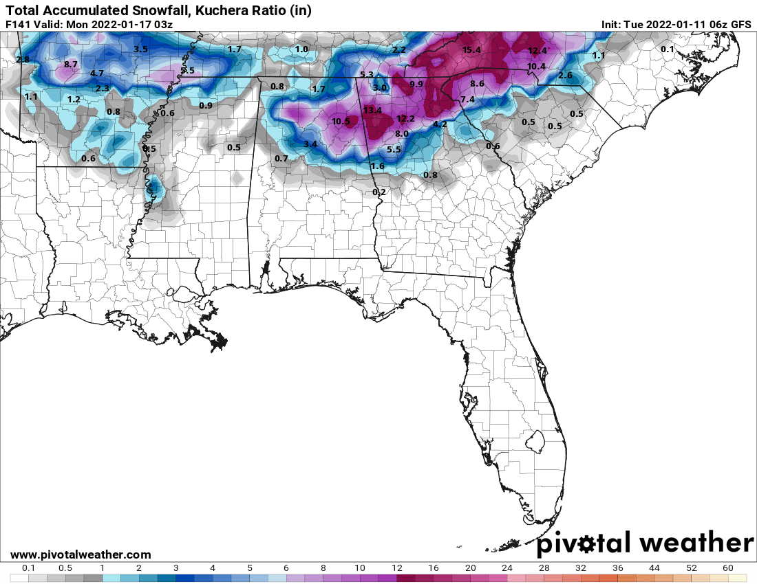
Quote.LONG TERM /FRIDAY THROUGH MONDAY/... As of 300 am EST Tuesday: Friday will provide a brief lull between systems as a shallow ridge sets up between a departing shortwave trough and the next major system amplifying over the northern Plains. We are trying to keep our excitement in check for the weekend system given the spread evident in the operational models and ensembles. Uncertainty remains high, but there are trends toward greater confidence in at least some wintry weather affecting much of our region over the weekend. The setup will include a zonally-oriented 850 mb baroclinic zone atop our region just north of the old frontal zone Friday night. This could well provide a focus for moist upglide redeveloping quickly across the area Friday night into Saturday. Subfreezing 850 mb temps would permit wintry ptypes at onset in most areas, with mainly snow in the northern tier and possibly a light wintry mix farther south as profiles wet bulb down. Meanwhile, the deepening upstream system will dive southeast through the central CONUS the first half of the weekend and amplify west of the Appalachians. Run- to-run and model-to-model consistency issues abound, with the operational GFS now much deeper with an H5 low tracking across the Deep South Saturday night. The ECMWF and Canadian camps depict more of a positively-tilted open wave crossing the forecast area. The common factors include fairly cold profiles already in place and decent potential for moisture return ahead of the amplifying system. The main difference is that the ECMWF/CMC solutions would be a quicker hit/shorter duration, which would limit wintry accumulations a bit more. The GFS, on the other hand, exhibits a far more dynamic southern closed low position, bringing the heart of its moisture and forcing over the cold air in place Saturday night through Sunday. In fact, the 850 mb low center track on the GFS is perfect for record setting snowfalls across our region. This solution has the surface low tracking through southern AL/GA along the frontal zone Saturday night and deepening over the SC coastal waters on Sunday. In addition, frontogenesis would be robust atop our area in this case, and a lobe of negative EPV crossing the region would even suggest some potential for thundersnow. However, it`s important to note the recent consistency issues with the GFS runs, and the fact that the GEFS plumes have plenty of spread. Still, the prudent course is to to start featuring the system in the HWO given the potential for accumulating snowfall. The upper system will depart late Sunday, but with lingering northwest flow snowfall quite possible along the spine of the southern Appalachians. Additional height falls may occur back to the west over the Ohio River Valley on Monday. This early week system appears a bit more moisture starved, and it seems the better dynamics will pass north of our forecast area. However, additional scattered snow showers will be possible in the mountains following the wave passage late Monday given the northwest flow upslope moisture in the residual cold air.-
3
-
-
4 minutes ago, lilj4425 said:
Hopefully those are mostly just trees on that Tuscaloosa debris ball.
It's moving into a residential area with schools as I type based on radar position verse google maps.
-
 1
1
-
-
37/22 Near SC/NC state line north of Gaffney
-
I took these a few mins ago. What you see happened in the past hour. I'm 1 mile from the NC line holding steady at 31.5 - 31.8 temp wise.


-
1 hour ago, cigrgd said:
I wonder when GSP will update their forecast lol
I'm sitting at 31.7 currently and it's still pounding with no immediate end in sight lol. It's been heavy snow for the past hour for me near the NC line north of Gaffney. We have at least 3/4" on the ground right now.
-
1
-
-
70%/30% rain verse small flakes north of Gaffney near the state line. Temp is 37.7 and dew point is 27.1 at the moment IMBY.
-
2
-
-
My forecast low was 32 already at 28.8 near the NC line north of Gaffney, SC.
-
My temp is down to 32 and still falling north of Gaffney near the state line. I'm hoping we get back above freezing by onset of the rain later tonight.


Jan 15-16 Winter Storm
in Southeastern States
Posted