
SnowMan
-
Posts
4,141 -
Joined
-
Last visited
Content Type
Profiles
Blogs
Forums
American Weather
Media Demo
Store
Gallery
Everything posted by SnowMan
-
Interesting. I was looking at 13z vs. 20z and looking at total precip 20z looks juicier.
-
20z HRRR colder....ok maybe there's a chance for some decent ZR
-
Of course right as I say that, this run is warmer. Sleet profile showing almost 3 inches just to northwest....
-
HRRR back to upping overall freezing rain totals the last couple runs. Hoping it continues as I would like some serious ice.
-

MO/KS/AR/OK 2025-2026 Winter Discussion
SnowMan replied to stormdragonwx's topic in Central/Western States
I am in North Texas - Celina area. Looking forward to see how much ZR we get. -
Yep - up here in Celina - I am looking at 4-6 and hoping for 8 lol
-
Wonder how much snow melt we will see up in North Texas today before tomorrow's storm. Hopefully not too much, but with a high around 20 and the sun angle we could see more than expected.
-
Wow and NAM is more robust with the QPF...
-
So we in the northwest corner of collin county. Looks like sleet/freezing rain.
-
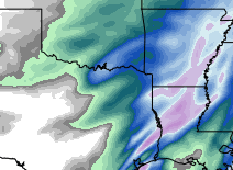
Yeah I am pulling up the GFS...new at reading models, but doesn't seem like there is a ton of QPF with this. Although it does look it drops right over our house lol. We are located where the blue/purple is in north texas.
-
What do you mean exactly? What are you seeing?
-
Texas/New Mexico/Louisiana/Mexico Obs And Discussion Thread Part 8
SnowMan replied to wxmx's topic in Central/Western States
I’m in Celina. Hoping for a massive ice storm. -
If this happens will it be overhead or will I have to find a clear spot with a good horizon view?
