
NoDoppler4TnySandz
-
Posts
112 -
Joined
-
Last visited
Content Type
Profiles
Blogs
Forums
American Weather
Media Demo
Store
Gallery
Posts posted by NoDoppler4TnySandz
-
-
I think it's a combination of factors...warm weekend, early season, waiting for it to wagons west...rainy slop
")
I checked out for 24 hours and just took look at the NAM....looks alot like the Euro 00z....this is a big Euro run coming up (fingers crossed)
-
9AM Forecast Discussion - ILN
LONG TERM /FRIDAY NIGHT THROUGH WEDNESDAY/...
Clearly the feature(s) and time period of interest during this
portion of the forecast will be the potential phasing of a southern
stream shortwave trough with a more progressive/dynamic northern
stream shortwave trough in the Monday/Tuesday timeframe, which could
lead to rapidly deepening/occluding low pressure tracking from the
southern Gulf Coast up the west side of the Appalachians. This would
bring a potential of cold sector precipitation /possibly the first
widespread accumulating snow of the winter/ and gusty winds. Outlier
/low probability/ solutions indicate that significant accumulating
snow could occur, but would take near ideal phasing for such an
event to occur.

What we feel somewhat confident in saying - is that ensembles means
have trended toward a wetter and colder overall solution for
Mon/Tue, so the chances of the first widespread accumulating snow
have risen over the last 24 hours. But overall probabilities of the
very heavy amounts seen in some recent deterministic runs of a few
models remain quite low - but something that has to be accounted
for. We will need to watch this closely as even a more conservative
snowfall forecast will bring travel impacts most likely Monday night
into Tuesday morning - but areas / amounts are still way too early
say with any measure of confidence.

Pre-storm mild temps - a key point about the quiet weather
Saturday/Sunday we need to mention is mild temperatures. Plenty of
sunshine both days should push temperatures well into the 40s on
Saturday, and 50s on Sunday. Cirrus thickens Sunday afternoon, and
mid clouds thicken Sunday night. The mild days Sat/Sun and clouds
Sunday night will keep soils/pavements quite warm, so snowfall will
need to overcome this to accumulate efficiently.

Phasing/low track -Timing of the potential phasing is key and
extremely low confidence at this time range, but some degree of
phasing is likely to occur between these systems - carving out a
deep longwave trough/closed low over the Ohio Valley by Tuesday
morning. Potential solutions run the gamut - from a rapidly
deepening low running from the Gulf Coast into western PA where it
slows to a stop and pivots, to a much weaker/progressive low riding
quickly through KY/WV/PA and into the northeast or off the Mid-
Atlantic coast.  The 26.00Z EPS and GEFS members /81 members in sum/
are all over the place with timing/track/precipitation coverage with
the various degrees of phasing which could occur. Still waiting to
see a clustering of surface low track/depth emerge from ensemble
systems. As of right now, the 31 members of the 26.00Z GEFS valid at
18Z Monday have surface lows scattered over thousands of square
miles from southeast Michigan, to upstate New York, to a number of
lows even down in the Carolinas. Each of these a viable solution -
and it is a representation of the sensitivity of phasing weather
systems separated /right now/ by thousands of miles. The 26.00Z
EPS/CMC ensembles also very similar - indicating surface low
pressure track/depth is variable and very low confidence at this
point in time.

Keys to remember about some of the extreme snowfall amounts being
seen on a few deterministic/ensemble members:  1) these static ratio
amounts do not account for the very warm ground temperatures
(remember Sunday`s temps in the 50s) 2) these do not take into
account the degree of compaction that would occur with a long
duration wet snow event that is leading to some of the very high
totals 3) boundary layer temperatures will remain 30-35 during any
snow that falls which means slower accumulation rates and more
compaction especially during daylight hours and 4) this storm has no
bitter arctic air in place or available to tap - unlike a very
similar setup 70 years ago when the Snow Bowl storm produced in
excess of 12-15" in the ILN CWA. That storm had surface temps in the
single digits and teens. Also pointing against the extreme solutions
is a very narrow dendritic growth zone - less than 100mb on forecast
soundings.  So we will need to watch ensembles closely in the next
couple of days to see if a trend emerges on a number of fronts.
Definitely a forecast to stay tuned to through the holiday weekend.

After the system pulls out on Wednesday, cold temperatures remain
with highs generally in the 30s.
-
 1
1
-
-
Well, I guess the season is here....might as well start it off with a tease followed by a kick in the N@!S
Good to have something to watch...
Two things strike me so far:
Like Stebo referenced: it definitely looks like it could stop and spin for a couple of days (consistent signal)...could be a N-S strip of jack-pot zone (Ohio/Ind border in general as of right now with W-E variance from Indy-CMH).
I also could see this evolve like Schaumburg mentioned --- Stung Out POS
Happy Turkey Day!
-
1
-
-
 16 minutes ago, iluvsnow said:
Transitioned to all snow....and heavy right now in Bellbrook. Too bad its 35 degrees and with a late Feb sun angle....snow is slushing on the grass....and just wet roads. Still in this God forsaken winter....its all we have.
Reposting so I can update my reaction in this "winter of despair".... still raining down here but I am hopeful!
-
1 hour ago, Hoosier said:
Should run farther north than the current storm. We'll see what happens.
Can we wishcast and suggest it will follow the snowpack from the current system ....run south of the map above?
Please?
Need some help down here.....final call....1' + of rain
-
Even down here by the river...."Southtown" ...it's snowing!

-
1
-
-
Fluffy dusting down here this morning....should qualify as a trace...not sure if KCVG saw the same. LOL!
Pattern has to flip at some point...Down here, Feb is our snowiest month. I can take that without the brutal cold that Jan can produce....... I know the lack of snow is frustrating...but at least it's not the cold is too strong and the storm tracks are south-- that's the worst.
-
1
-
-
24 minutes ago, buckeye said:
Make it end please....


Lock it in....guaranteed to verify (LMAO)-- such is the life we live during winter, here in Ohio!
The irony is spot on that you can't help but laugh; particularly with Buckeyes comment...no one is better at getting kicked when they are down than this part of the sub-forum.
-
2
-
-
24 minutes ago, buckeye said:
One of the reason I like an early spring and loathe a winter that refuses to completely give up....like last year. I love snow on snow....it's so rare though. Nothing like tracking the next event while you're in the midst of a warning level event. It seems like the big dogs tend to wash away within a few days.
March'08 was the unicorn exception. Not only was it the largest snowfall in cmh history, it actually had better and longer staying power than most of our mid winter events.
Speaking of March '08.... for old time sakes. I took this pic driving around during that storm in Westerville. sigh
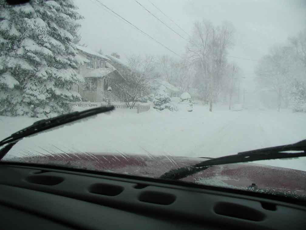
That's rip city right there-- and the photo never does it justice. Looks like 500-750 ft visibility --- ??? Coming down there...
-
These really cold patterns have a tendency to produce surprises from time to time-- don't need a lot of qpf to squeeze out something noticeable.... I am more curious on the Thursday PM/Night chances....even ILN is referencing a couple of inches for my local forecast-- which is not typically characteristic 24+hours out....
-
27 minutes ago, buckeye said:
This is a very accurate precip type radar.
You're all gonna need one lol
Thanks for sharing...will keep it refreshed for sure! I bought some steaks yesterday in the rush to grocery....I run my grill year round....not saying it's for sure, but it is a possibility.
-
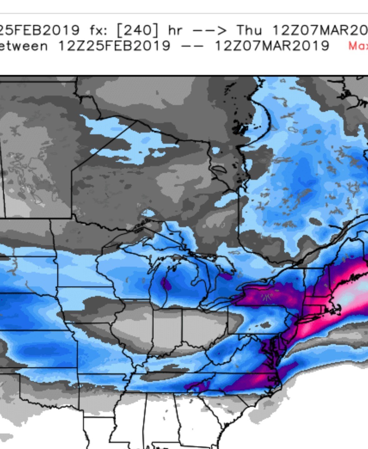
The deform band is going to be impressive wherever it gets going and can last the longest...sometime this afternoon/evening...it's going to be rip city somewhere...as of last nights models it looked like it could have been around here ..... SE Cincy...the models have shown the band over muti model suites at various times, from S Central Indiana- E of Cincy...up through Columbus...the rates should be intense. I still like the cold winning at some point-- backside accumulations have been good down here, this year- that's different from previous years IMO -- the qpf/lift was gone by the time the cold air came.
Let the frustration go and enjoy this powerful storm....at least down here...3-5" events aren't easy to come by....particularly if its dumped in a compressed period of time.
-
1 minute ago, snowlover2 said:
.png.21cef228b53fe185c545833841c87c3e.thumb.png.708bdd1cf59998f1520a0da8850e4798.png)
Oh yeah...that 9 would be right about IMBY here in SE Cincy-- love the thought of that deformation band thump to get us there.........please, godfater....please be right ....we have been so good...
-
1
-
-
Well someone said it years ago...can't remember if it was on AmericanWx or a local board down here....."sometimes you have to smell the rain, to get the heavy snow"
Nonetheless, this sure beats what we had in Dec...it was so quiet I thought Buckeye may have been vaporized by aliens.....total crickets
-
 1
1
-
-
Guys--- if I were in CMH or vicinity-- you have like where you are sitting and the trends of recent....
-
5 minutes ago, NoDoppler4TnySandz said:
This has been my thoughts all day too--- weren't the 12z runs the first to really sample? Or am I wrong on this...if just one run...let's roll trhu a couple of runs before we set things as all she wrote.
And heck, I am still optimistic to get several quality inches out of this...and we are slop central as that suggested sub forum for SDF-PIT....boy, talk about a miserable thread....we get screwed so bad, you would need some meds if you dared to participate.
-
44 minutes ago, vespasian70 said:
Yea, good thing is though at this point it is a possibility. This cake hasn't set yet.
This has been my thoughts all day too--- weren't the 12z runs the first to really sample? Or am I wrong on this...if just one run...let's roll trhu a couple of runs before we set things as all she wrote.
-
Hey Guys-- greetings of the season! I have been lurking so far this winter, not posting....good to see all the usual members.
Curious about timing...is the Euro any quicker with the onset of precip from the GFS or FVGFS (forget the ICON for now).... seemed like the weekend event didn't get going until 4 AM Sat or later for the OH crew?
I am actually driving later Friday/early Saturday...from MO to CVG....been feeling pretty good about staying in front of the weather for the most part..with warmer temps and timing - to my destination several hours in advance of the precip onset.
Was curious if anyone saw anything different on the timing.
-
.3 of an inch of ice in SE Cincy this morning (mostly trees and elevated surfaces --- power outages exceeded 100k at it's peak with close to 1000 outage locations.
Might just get a nice dusting this evening from the "Reach Around"--
Interesting start to the season indeed.
-
8 hours ago, Hoosier said:
That thing was crawling apparently (forward speed listed at 5 or 10 mph in the warning)
8 hours ago, snowlover2 said:Appears a tornado possibly touched down in SE IN west of Cincy about an hour ago.
Not seeing anything on ILN or in media....any additional information on this?
That line that developed back that way popped up out of nowhere on the east side of Cincy too....kinda weird, more about heavy rain but the wind started howling at one point....I looked at the radar an hour earlier and all the storms had dissipated from the evening round...then an hour later...boom!
.png.21cef228b53fe185c545833841c87c3e.png.b3c893a7f91a99c1bd863bacfb4f1818.png)
Winter 2020/2021 Short Range Discussion
in Lakes/Ohio Valley
Posted
Pleased to report that we have a "scattering" of grapel that has spread across the grass and elevated deck.
Encouraged by the energy upstream which could pivot towards the donut hole of the region and lay down a 1/2 inch later today into the evening hours!